
Carn Glas


Chambered Cairn(S) (Neolithic)
Site Name Carn Glas
Classification Chambered Cairn(S) (Neolithic)
Alternative Name(s) Achvraid; Essich Moor
Canmore ID 13164
Site Number NH63NW 14
NGR NH 6493 3830
NGR Description Centred NH 6493 3830
Datum OSGB36 - NGR
Permalink http://canmore.org.uk/site/13164


- Council Highland
- Parish Inverness And Bona
- Former Region Highland
- Former District Inverness
- Former County Inverness-shire
NH63NW 14 centred 6493 3830
For extensive group of hut-circles adjacent to W, see NH63NW 17.
(NH 6493 3830) Carn Glas {NR}
OS 6" map, Inverness-shire, 2nd ed., (1905).
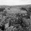
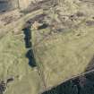
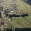
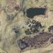
These three cairns of the Orkney-Cromarty Group built on end along a small narrow ridge, one of a number which runs north to south across the area... The main body of the cairns is composed of naked small angular stones but the edges are overgrown and indistinct. The areas between the cairns are turf-covered but there is a low neck of cairn material below the turf connecting the cairns proper. In plan the cairns are more or less parallel sided with rounded ends. The north cairn measures 120 feet north to south and 57 feet across the chamber.
Thirty feet to the south lies the centre cairn measuring 76 feet north to south by 47 feet east to west. About thirty feet further south lies the last cairn, 124 feet long by 94 feet wide. The positioning of the chambers and the intermediate necks of cairn material suggest the cairns were regarded as a whole: the overall length is 380 feet. On the other hand, at the southend of the centre cairn there are a few earth-fast stones which suggest there may have been a peristalith of spaced stones encircling the individual cairns. In each of the cairns there is exposed part of a chamber. These all appear to be similar, rectangular in form and constructed of large flat slabs set on edge.
ISSFC 1902; V G Childe 1944; A S Henshall 1963, visited 11 April 1957.
Carn Glas: These cairns are as described above; and, as stated, appear on the ground as one unit, each separated by a short space of turf-covered debris. The cairns vary in height from c. 3.5m. on the south; c. 1.2.m centrally; to 2.0m on the north. Overall the mass measures 116m. N-S.
Revised at 1/2500.
Visited by OS (J L D) 21 March 1962.
Field Visit (August 1943)
Chambered Cairn (s), Essich Moor.
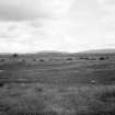
On Essich Moor is a wide ridge above the 700’ contour sloping up gently to above 750’ on the south, whence it continues as Drumashie Moor but falling away rather more steeply to the north; it forms the watershed between the Allt Mor (that flows out of Loch Ashie) and the Ness. The broad crest is cut into several parallel gravelly ridges by shallow swampy depressions. The whole area is now covered in heather and peat and practically treeless. At the north end of the easternmost of the minor component ridges are three heaps of naked stones in line running north and south, separated by two rather lower and grass-grown but still stony tracts 30’ wide, the whole series extending over a total length of 380’. No peristalith or peristaliths are exposed to define the monuments; grass and heather are encroaching upon the cairn material; on the other hand cairn stones may have been spread about by indiscriminate plunderers; finally the frontier between cairn material and virgin soil which itself is gravel cannot be easily discerned. The monument has evidently been used as a quarry for stones, perhaps for building or repairing Gen. Wade’s Inverness—Stratherrick road that runs less than ¼ m to the west. Hence the form, dimensions and elevation of the original monuments cannot be defined with any precision. What the visitor actually sees are three irregular heaps of naked stones, bearing a few whins and thorns, which will be treated for purposes of description as three distinct cairns.
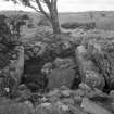
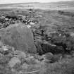
On the north, bare stones form a continuous cairn 120’ long north and south, 57’ wide just behind the chamber and 50’ wide 100’ from the north end, surviving to a height of some 6’ round the chamber. Near the north end are exposed an erect portal stone rising 3’ above the cairn material, and west side of a passage 9’8” long leading to a cist 6’ long x 4’9” wide at its apparent end. Of the passage wall 2 slabs on edge respectively 3’6” and 4’4” long have been exposed to a height of 1’4” and 2’2” by trenching along their outer west sides. The inner side of a corresponding slab 3’3” long parallel to the innermost on the west is also exposed on the east. The cist itself is more fully cleared though the floor is cumbered with a layer of boulders of uncertain depth. Its sides are formed by two large slabs on edge almost parallel but not in line with the passage sides. That on the west is 6’1” long 1’1” thick and 2’2” high above the boulders, its east counterpart 5’9” x 10’ x 3’1”. The south end of the cist seems to be formed by a very low headstone. This is only 2’2” long and so does not close the chamber, the SW corner being filled only with boulders. West of the west lateral slab is another large slab leaning against it measuring 6’7” x 3’0” x 10”—perhaps a lintel. A rowan tree is growing just south of the apparent end of the cist. 33’ south of the latter and 8’ west of the axis, but at right angles thereto, the upper edge of a slab 1’8” wide and 5” thick just projects through the cairn material. Near the SW corner is a hollow in which slabs on edge are exposed among large boulders.
The central cairn, much overgrown with whins, seems to measure 76’ north and south x 47’ east and west. Near its apparently northern margin is a thick horizontal slab apparently covering a cavity, while near the centre some slabs on edge are exposed in a hole made by pillagers. At the south east corner the corner of a megalithic cist partly demolished is fully exposed. The ‘headstone’ on the west is 4’9” long, 1’ thick and rises 3’3” high above the moss-clad boulders that line the cist. The south side is a slab 2’10” long at right angles to the headstone but 1’6” lower than it. The north side is missing, while there may have been an entrance on the east equally lost.
The south cairn, on the high end of the ridge, is 124’ north and south and 94’ east and west across the chamber and perhaps 8’ high. Near the centre the inner end of a chamber, presumably running north and south, is exposed; the headstone is a solid block 5’ wide and 1’6” thick, and rising 5’ 6” above debris on the chamber floor. Making a small angle with its east end is a small pointed slab 2’10” x 1’8” high to its apex. Beyond this, but at a less sharp angle with the headstone (still less than a right angle) the side is continued by a second slab 3’4” long and exposed 2’4” high. In the corner drystone masonry of flat slabs, oversailing inwards over the east edge of the headstone, fill up the irregularities of the NE stone and bring the wall at this point up to the height of the second wall-slab, but this masonry continues behind the second slab. The west side of the chamber and its entrance on the south are entirely hidden in debris.
This monument-complex might be regarded as the remains of three cairns of the Beauly-Nairn-Spey type set in line (as at Clova) and reduced to chaos by stone-robbers. Nevertheless the structure of the chambers with split slabs instead of boulders, the presence of a lateral chamber and the situation on a high moor above the 700’ contour, differentiate the complex sharply from any cairn of that group such as Ballindarrach and even [?] which stand on the same watershed. Mr James D McCulloch, in his little pamphlet Essich & its Traditions, published by Munro, Aberdeen, regards the monument as one long cairn. Though it is very much longer than any other cairn in Scotland and it may still be a composite monument it should perhaps be connected with the Clyde or Pentland groups rather than with the Beauly.
Visited by RCAHMS (VG Childe), August 1943.
OS ref: xx (‘Carn Glas’)
Management (2007)
(Scheduling no. 2392). Scheduled as 'Carn Glas... a complex long cairn formed of three linked chambered cairns, visible as a series of stone structures set into a natural saddle-shaped ridge on Essich Moor.'
Information from Historic Scotland, scheduling document dated 1 March 2007.

