
Lewis, Barvas


Head Dyke (Post Medieval), Lazy Beds (Post Medieval), Township (Period Unassigned)
Site Name Lewis, Barvas
Classification Head Dyke (Post Medieval), Lazy Beds (Post Medieval), Township (Period Unassigned)
Canmore ID 131319
Site Number NB35SE 53.03
NGR NB 3505 5015
NGR Description Centred NB 3505 5015
Datum OSGB36 - NGR
Permalink http://canmore.org.uk/site/131319


- Council Western Isles
- Parish Barvas
- Former Region Western Isles Islands Area
- Former District Western Isles
- Former County Ross And Cromarty
Note
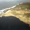
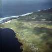
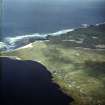
Three separate occupied crofting townships can be identified on the 1st edition of the OS 6-inch map (Island of Lewis, Ross-shire 1853, sheet 8). In addition two lengths of head-dyke lie within this site.
(NB 3505 5015) A crofting township, comprising eighteen roofed and six unroofed buildings is depicted on the 1st edition of the OS 6-inch map (Island of Lewis, Ross-shire 1853, sheet 8). Thirty-six roofed, six partially roofed and nine unroofed buildings are shown on the current edition of the OS 1:10000 map (1974).
(Centred on NB 361 500) A crofting township, comprising thirty-nine roofed buildings, one partially roofed and twenty-five unroofed buildings is depicted on the 1st edition of the OS 6-inch map (Island of Lewis, Ross-shire 1853, sheet 8). Sixty-eight roofed, five partially roofed and thirteen unroofed buildings are shown on the current edition of the OS 1:10000 map (1974).
(Centred on NB 3655 5090) A crofting township, comprising nineteen roofed buildings, of which one is a corn-drying kiln and twenty-five unroofed buildings is depicted on the 1st edition of the OS 6-inch map (Island of Lewis, Ross-shire 1853, sheet 8). Thirty-two roofed, three partially roofed and three unroofed buildings are shown on the current edition of the OS 1:10000 map (1974).
Information from RCAHMS (AKK) 20 February 1997.

