 |
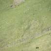
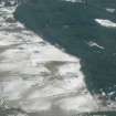
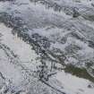
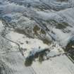
On-line Digital Images |
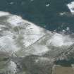
DP 211689 |
RCAHMS Aerial Photography Digital |
Oblique aerial view of the hut circle at NH 51339 61344, looking WSW. |
14/5/2015 |
Item Level |
|
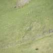 |
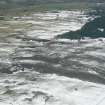
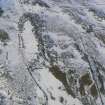
On-line Digital Images |
DP 211690 |
RCAHMS Aerial Photography Digital |
Oblique aerial view of the hut circle at NH 51339 61344, looking WSW. |
14/5/2015 |
Item Level |
|
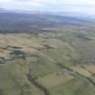 |
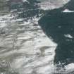
On-line Digital Images |
DP 341092 |
Papers of James Sloan Bone, landscape historian, Inverness, Highland, Scotland |
Oblique aerial view, looking N over the Heights of Fodderty and the Heights of Brae, near Dingwall. |
17/2/2008 |
Item Level |
|
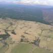 |
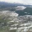
On-line Digital Images |
DP 341093 |
Papers of James Sloan Bone, landscape historian, Inverness, Highland, Scotland |
Oblique aerial view, looking NNW over the Heights of Fodderty in the foreground towards Ben Wyvis, near Dingwall. |
17/2/2008 |
Item Level |
|
 |
On-line Digital Images |
DP 341663 |
Papers of James Sloan Bone, landscape historian, Inverness, Highland, Scotland |
Oblique aerial view of croft land above Heights of Fodderty near Dingwall, Easter Ross, looking WNW. |
6/3/2009 |
Item Level |
|
 |
On-line Digital Images |
DP 341673 |
Papers of James Sloan Bone, landscape historian, Inverness, Highland, Scotland |
General oblique aerial view of the Heights of Fodderty and the Strath Sgitheach of the River Peffery, near Dingwall, Ross-shire, looking SW. |
6/3/2009 |
Item Level |
|
 |
On-line Digital Images |
DP 341677 |
Papers of James Sloan Bone, landscape historian, Inverness, Highland, Scotland |
Oblique aerial view of croft land and commercial forestry above Heights of Fodderty near Dingwall, Ross-shire, looking WSW. |
6/3/2009 |
Item Level |
|
 |
On-line Digital Images |
DP 341687 |
Papers of James Sloan Bone, landscape historian, Inverness, Highland, Scotland |
General oblique aerial view of the south facing slopes above and to the north of the River Peffery west of Dingwall Ross-shire, looking W. |
6/3/2009 |
Item Level |
|
 |
On-line Digital Images |
DP 341690 |
Papers of James Sloan Bone, landscape historian, Inverness, Highland, Scotland |
Oblique aerial view of improved croft land above and to the north of the Strath Sgitheach of the River Peffery west of Dingwall, Ross-shire, looking WSW. |
6/3/2009 |
Item Level |
|
 |
On-line Digital Images |
DP 341691 |
Papers of James Sloan Bone, landscape historian, Inverness, Highland, Scotland |
Oblique aerial view of a farmstead at Heights of Fodderty, near Dingwall, Easter Ross, looking NW. |
6/3/2009 |
Item Level |
|
 |
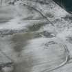
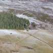
On-line Digital Images |
DP 341918 |
Papers of James Sloan Bone, landscape historian, Inverness, Highland, Scotland |
Aerial view of Heights of Brae hut circles and field boundary, near Dingwall, Easter Ross, looking NE. |
22/1/2010 |
Item Level |
|
 |
On-line Digital Images |
DP 341919 |
Papers of James Sloan Bone, landscape historian, Inverness, Highland, Scotland |
Aerial view of Heights of Brae hut circle and rig cultivation, near Dingwall, Easter Ross, looking NNE. |
22/1/2010 |
Item Level |
|
 |
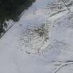
On-line Digital Images |
DP 341920 |
Papers of James Sloan Bone, landscape historian, Inverness, Highland, Scotland |
Aerial view of Heights of Brae hut circle, near Dingwall, Easter Ross, looking NE. |
22/1/2010 |
Item Level |
|
 |
On-line Digital Images |
DP 341921 |
Papers of James Sloan Bone, landscape historian, Inverness, Highland, Scotland |
Aerial view of Heights of Brae hut circle, near Dingwall, Easter Ross, looking NNW. |
22/1/2010 |
Item Level |
|
 |
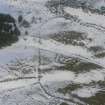
On-line Digital Images |
DP 341923 |
Papers of James Sloan Bone, landscape historian, Inverness, Highland, Scotland |
Aerial view of Heights of Brae, near Dingwall, Easter Ross, looking SW. |
22/1/2010 |
Item Level |
|
 |
On-line Digital Images |
DP 341924 |
Papers of James Sloan Bone, landscape historian, Inverness, Highland, Scotland |
Aerial view of Heights of Brae hut circle, near Dingwall, Easter Ross, looking NE. |
22/1/2010 |
Item Level |
|
 |
On-line Digital Images |
DP 341925 |
Papers of James Sloan Bone, landscape historian, Inverness, Highland, Scotland |
Aerial view of Heights of Brae, near Dingwall, Easter Ross, looking N. |
22/1/2010 |
Item Level |
|
 |
On-line Digital Images |
DP 342386 |
Papers of James Sloan Bone, landscape historian, Inverness, Highland, Scotland |
Aerial view of Heights of Brae, near Strathpeffer, earlier field system and hut circle, looking NNE. |
15/2/2011 |
Item Level |
|
 |
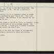
On-line Digital Images |
SC 2363064 |
Records of the Ordnance Survey, Southampton, Hampshire, England |
Heights Of Brae, NH56SW 3, Ordnance Survey index card, Recto |
1958 |
Item Level |
|
 |
On-line Digital Images |
SC 2363065 |
Records of the Ordnance Survey, Southampton, Hampshire, England |
Heights Of Brae, NH56SW 3, Ordnance Survey index card, page number 2, Verso |
1958 |
Item Level |
|
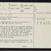 |
On-line Digital Images |
SC 2363066 |
Records of the Ordnance Survey, Southampton, Hampshire, England |
Heights Of Brae, NH56SW 3, Ordnance Survey index card, page number 1, Recto |
1958 |
Item Level |
|


