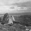
 |
On-line Digital Images |
SC 681468 |
Records of the Society of Antiquaries of Scotland, Edinburgh, Scotland |
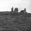
General view of chambered cairn.
Original negative captioned: 'Circle about 4 miles N.E. of Strathpeffer on moorland / Stone Circle called Clachan Gorach or "Foolish Stones" 1907'. |
1907 |
Item Level |
|
 |
On-line Digital Images |
SC 681469 |
Records of the Society of Antiquaries of Scotland, Edinburgh, Scotland |
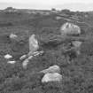
View of remains of chamber.
Original negative captioned: 'Cist at Stone Circle called Clachan Gorach i.e. "The Foolish Stones" nearly 5 miles North East of Strathpeffer 1907'.
|
1907 |
Item Level |
|
 |
On-line Digital Images |
SC 682284 |
Records of the Society of Antiquaries of Scotland, Edinburgh, Scotland |
General view of cairn.
|
|
Item Level |
|
 |
On-line Digital Images |
SC 1401658 |
Records of the Royal Commission on the Ancient and Historical Monuments of Scotland (RCAHMS), Edinbu |
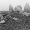
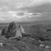
Heights of Brae, main cist and stones D and E from south east. |
30/8/1943 |
Item Level |
|
 |
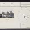
On-line Digital Images |
SC 1453981 |
Records of the Royal Commission on the Ancient and Historical Monuments of Scotland (RCAHMS), Edinbu |
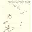
Sketch plan of Heights of Brae chambered cairn (extract from manuscript) |
30/8/1943 |
Item Level |
|
 |
On-line Digital Images |
SC 1457158 |
Records of the Royal Commission on the Ancient and Historical Monuments of Scotland (RCAHMS), Edinbu |
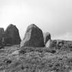
Heights of Brae chambered cairn, main and NW cists from NW. |
30/8/1943 |
Item Level |
|
 |
On-line Digital Images |
DP 211684 |
RCAHMS Aerial Photography Digital |
Oblique aerial view of the Heights of Brae chambered cairn, looking W. |
14/5/2015 |
Item Level |
|
 |
On-line Digital Images |
DP 211685 |
RCAHMS Aerial Photography Digital |
Oblique aerial view of the Heights of Brae chambered cairn, looking WSW. |
14/5/2015 |
Item Level |
|
 |
On-line Digital Images |
DP 211686 |
RCAHMS Aerial Photography Digital |
Oblique aerial view of the Heights of Brae chambered cairn, looking NNW. |
14/5/2015 |
Item Level |
|
 |
On-line Digital Images |
DP 211687 |
RCAHMS Aerial Photography Digital |
Oblique aerial view of the Heights of Brae chambered cairn, looking NNW. |
14/5/2015 |
Item Level |
|
 |
On-line Digital Images |
DP 211688 |
RCAHMS Aerial Photography Digital |
Oblique aerial view of the Heights of Brae chambered cairn, looking NW. |
14/5/2015 |
Item Level |
|
 |
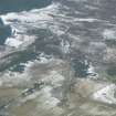
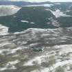
On-line Digital Images |
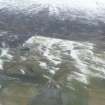
DP 341660 |
Papers of James Sloan Bone, landscape historian, Inverness, Highland, Scotland |
General oblique aerial view of the upper reaches of Strath Sgitheach north of Dingwall, Ross-shire, looking NW towards Ben Wyvis. |
6/3/2009 |
Item Level |
|
 |
On-line Digital Images |
DP 341661 |
Papers of James Sloan Bone, landscape historian, Inverness, Highland, Scotland |
General oblique aerial view of the upper reaches of Strath Sgitheach north of Dingwall, Ross-shire, looking NW. |
6/3/2009 |
Item Level |
|
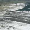 |
On-line Digital Images |
DP 341673 |
Papers of James Sloan Bone, landscape historian, Inverness, Highland, Scotland |
General oblique aerial view of the Heights of Fodderty and the Strath Sgitheach of the River Peffery, near Dingwall, Ross-shire, looking SW. |
6/3/2009 |
Item Level |
|
 |
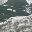
On-line Digital Images |
DP 341674 |
Papers of James Sloan Bone, landscape historian, Inverness, Highland, Scotland |
General oblique aerial view of part of the Strath Sgitheach, west of Dingwall, Ross-shire, looking W. |
6/3/2009 |
Item Level |
|
 |
On-line Digital Images |
DP 341676 |
Papers of James Sloan Bone, landscape historian, Inverness, Highland, Scotland |
Oblique aerial view of Upper Strath Sgitheach north of Dingwall, Ross-shire, looking W. |
6/3/2009 |
Item Level |
|
 |
On-line Digital Images |
DP 341688 |
Papers of James Sloan Bone, landscape historian, Inverness, Highland, Scotland |
General oblique aerial view of part of the Strath Sgitheach of the River Peffery W of Dingwall, Ross-shire, on the left, and of upper Strath Sgitheach on the right, looking W. |
6/3/2009 |
Item Level |
|
 |
On-line Digital Images |
DP 341689 |
Papers of James Sloan Bone, landscape historian, Inverness, Highland, Scotland |
Oblique aerial view of rough ground in upper Strath Sgitheach, near Dingwall, looking W. |
6/3/2009 |
Item Level |
|
 |
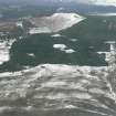
On-line Digital Images |
DP 341923 |
Papers of James Sloan Bone, landscape historian, Inverness, Highland, Scotland |
Aerial view of Heights of Brae, near Dingwall, Easter Ross, looking SW. |
22/1/2010 |
Item Level |
|
 |
On-line Digital Images |
SC 2246349 |
Records of the Royal Commission on the Ancient and Historical Monuments of Scotland (RCAHMS), Edinbu |
Heights of Brae chambered cairn, main and NW cists from NW. |
30/8/1943 |
Item Level |
|
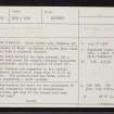 |
On-line Digital Images |
SC 2363058 |
Records of the Ordnance Survey, Southampton, Hampshire, England |
Heights Of Brae, NH56SW 2, Ordnance Survey index card, page number 1, Recto |
1958 |
Item Level |
|
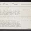 |
On-line Digital Images |
SC 2363059 |
Records of the Ordnance Survey, Southampton, Hampshire, England |
Heights Of Brae, NH56SW 2, Ordnance Survey index card, page number 2, Verso |
1958 |
Item Level |
|
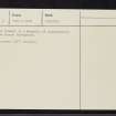 |
On-line Digital Images |
SC 2363060 |
Records of the Ordnance Survey, Southampton, Hampshire, England |
Heights Of Brae, NH56SW 2, Ordnance Survey index card, page number 3, Recto |
1958 |
Item Level |
|
 |
On-line Digital Images |
SC 2363061 |
Records of the Ordnance Survey, Southampton, Hampshire, England |
Heights Of Brae, NH56SW 2, Ordnance Survey index card, Recto |
1958 |
Item Level |
|


