
Cille Bhrea, Chapel And Burial Ground


Burial Ground (Medieval), Church (Medieval), Cross (Medieval)
Site Name Cille Bhrea, Chapel And Burial Ground
Classification Burial Ground (Medieval), Church (Medieval), Cross (Medieval)
Canmore ID 12912
Site Number NH56SE 3
NGR NH 57647 61489
Datum OSGB36 - NGR
Permalink http://canmore.org.uk/site/12912


- Council Highland
- Parish Kiltearn
- Former Region Highland
- Former District Ross And Cromarty
- Former County Ross And Cromarty
NH56SE 3 5764 6148.
(NH 57646148) Cille Bhrea {NR} Chapel {NR} (Ruin)
OS 6"map, (1938)
This was the parish church of Lemlair until that parish was united with Kiltearn after the Reformation.
Its original dedication was to Brig., one of the holy maidens of the Brigit who died in 525. It was latterly known as St. Mary's Chapel, probably a mis-translation of the original name.
The foundations are still visible in the churchyard, which is known as 'Cladh Mo-Bhrigh'
W J Watson 1904; N Macrae 1923; W J Watson 1926.
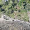
The remains of the Chapel measure 10.8 m EW by 4.4 m transversely with grass-covered walls 0.6 high and 0.7 m thick. The SE corner has been destroyed by erosion. A few grave-slabs can be seen within the chapel and immediately to the N of it, but the graveyard is unenclosed and derelict. The Name St. Brig's Chapel is still known locally.
Re-surveyed at 1/2500. Photo.
Visited by OS (N K B) 30 June 1965
Chapel (NR) (remains of)
OS 1:10,000, (1971)
This chapel was partially excavated by Dr Woodham (A A Woodham, Clava, Cunninghill Rd., Invervrie) in 1966. Finds include a stone font and part of the communion table, which are still in the chapel, and several skeletons. According to Woodham the dedication is to St Brigh, and the present remains date from about 1198 when the chapel was consecrated. There is no trace of graves in the unenclosed graveyard around the chapel, though human bones protrude from the eroding cliff face near the chapel. Woodham states that the last burial was about "100 years ago"
Visited by OS (N K B) 20 December 1976
Coastal processes are resulting in the erosion of the churchyard. The arm of a decorated, possibly a free standing, cross was found amongst the eroded material at the foot of the cliff. Human bones and iron coffin nails were also recovered from the eroding cliff face.
J Wordsworth, SSSIs, Scottish Natural Heritage, 1993
NH 576 614 An archaeological assessment was carried out to measure the extent of continued coastal erosion of both the chapel and graveyard. Skeletal remains, including one with associated coffin nails, were deposited with Historic Scotland.
Sponsor: Historic Scotland
J Wordsworth 1997
NH 576 614 Coastal erosion is steadily removing the E end of the chapel and exposing human skeletal material from the graveyard on the foreshore. Historic Scotland decided that a programme of managed retreat was appropriate, and commissioned the excavation of the elements of this medieval church and graveyard which were at risk from erosion over the next couple of decades.
The fieldwork in August 1998 examined a strip along the erosion edge, excavating 50 graves. These graves were nearly all orientated E-W and 21 contained skeletal material, in varying states of preservation. Some graves also contained coffin nails, with attached mineralised wood fragments, and a number of shroud pins were also recovered. The walls of the church were also exposed and recorded, and the interior of the church investigated. In accordance with Historic Scotland policy the human skeletal material, after analysis, will be buried in the graveyard, away from the erosion edge.
Sponsor: Historic Scotland
T Rees 1998
North wall and West wall remains of chapel upstanding 0.5-1.2m, remainder gone. Very serious erosion on frontage 4m cliff face. Burials eroding out. Whole set within enclosure boundary bank. Visible to East. Site subject to present day stabilisation work and clearance of scrub. 3 burial slabs visible within chapel walls and 2 outwith to North of structual remains.
CFA/MORA Coastal Assessment Survey 1998.
Field Visit (September 1978)
Cille Bhrea, Church NH 576 614 NH56SE 3
The overgrown remains of the pre-Reformation church of Lemlair stand on the edge of the Cromarty Firth. Known locally as Cille Bhrea, the church was probably dedicated to St Brigh. Tombstones, a fragment of door-jamb and a font are visible within the clay mortared building, which was partially excavated in 1966.
RCAHMS 1979, visited September 1978
(OPS 1851-5, ii, 481;Watson 1904, 85-6; Macrae 1923, 289; Cowan 1967, 129)
Field Visit (2013 - 2014)
Remains of N and W wall are upstanding to 0.5-1.2m. Enclosure boundary bank is visible to E along with 3 burial slabs within chapel walls and 2 out with chapel. Site is subject to present day stabilisation but there is very serious erosion on frontage at cliff face and burials are erosion out. Under threat from further cliff erosion.
Ad hoc coastal defence failing. Boundary band not visible. SE corner of chapel probably eroded. Only 2 grave slabs visible inside the chapel. None visible outside due to vegetation cover. A single piece of human bone visible at the base of the coastal section, but otherwise the section is vegetated and appears stable.
Visited by Scotland's Coastal Heritage at Risk (SCHARP) 2013

