
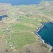
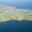
Lewis, Aird


Head Dyke (Post Medieval), Township (Period Unassigned)
Site Name Lewis, Aird
Classification Head Dyke (Post Medieval), Township (Period Unassigned)
Canmore ID 128139
Site Number NB53NE 8
NGR NB 5600 3600
NGR Description From NB 5630 3540 to NB 5610 3655
Datum OSGB36 - NGR
Permalink http://canmore.org.uk/site/128139


- Council Western Isles
- Parish Stornoway
- Former Region Western Isles Islands Area
- Former District Western Isles
- Former County Ross And Cromarty
NB53NE 8.00 centred on 5600 3600
NB53NE 8.01 5587 3576 Enclosures
NB53NE 8.02 5587 3640 Enclosures
A township, comprising sixteen roofed, five unroofed buildings and a head-dyke is depicted on the 1st edition of the OS 6-inch map (Island of Lewis, Ross-shire 1851, sheet 21). A crofting township is shown on the current edition of the OS 1:10000 map (1975).
Information from RCAHMS (AKK) 26 September 1997.

