
Unst, Brough Taing


Promontory Fort (Period Unassigned)(Possible)
Site Name Unst, Brough Taing
Classification Promontory Fort (Period Unassigned)(Possible)
Canmore ID 128
Site Number HP60SW 27
NGR HP 633 049
Datum OSGB36 - NGR
Permalink http://canmore.org.uk/site/128


- Council Shetland Islands
- Parish Unst
- Former Region Shetland Islands Area
- Former District Shetland
- Former County Shetland
HP60SW 27 633 049
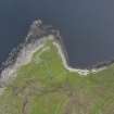
HP 633 049. A probable promontory fort lies about two- thirds of the way up the steep rocky slope on to the promontory between the North and South Geos of Brough, at Taing of Brough. The massive foundation courses of a strong stone wall are concealed by hummocky turf. On the promontory are traces of indefinite structures and towards the seaward end, two long rectangular buildings.
R G Lamb 1970
Lamb's 1970 account of a promontory fort between the Noth and South Geos of Brough, corresponds with his 1980 description of the promontory fort at Taing of Brough, Flubersgerdie (HP51SE 1). It is likely that the location cited above is erroneous.
Information from RCAHMS (PM) 6 January 2009 based on information provided by Brian Smith, Shetland Archives
R G Lamb 1970, R G Lamb 1980.

