
Gilchrist


Enclosure (Prehistoric)(Possible), Pit(S) (Period Unknown), Rig And Furrow (Medieval) - (Post Medieval), Roundhouse (Prehistoric)
Site Name Gilchrist
Classification Enclosure (Prehistoric)(Possible), Pit(S) (Period Unknown), Rig And Furrow (Medieval) - (Post Medieval), Roundhouse (Prehistoric)
Canmore ID 12685
Site Number NH54NW 26
NGR NH 5422 4901
NGR Description Enclosure at NH 5422 4901
Datum OSGB36 - NGR
Permalink http://canmore.org.uk/site/12685


- Council Highland
- Parish Urray (Ross And Cromarty)
- Former Region Highland
- Former District Ross And Cromarty
- Former County Ross And Cromarty
NH54NW 26 5422 4901
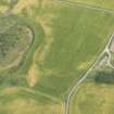
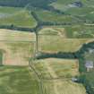
NH 542 490. Air photography has revealed the crop-mark of what is probably a circular enclosure 350 m SE of Gilchrist farmhouse; it measures about 20 m in diameter within a narrow ditch.
RCAHMS 1979; Visible on RCAHMS air photographs RC 1857-60, flown 1978
Further aerial photographs were taken of this enclosure. There appears to be a large pit to the NW of it.
(See Archive for details.)
Information from J Harden 1989.
Cropmark of circular ditched enclosure c 25m in diameter, with smaller ring of post-holes adjoining to the W; 200m NW of Bellevue Cottages.
J S Bone 1996k
Recent aerial photographs (RCAHMSAP 1995) suggest that this is a possible enclosure of uncertain function. It has an internal diameter of about 30m and a broad gap on the E side. About 10m NW of the enclosure the cropmark of a probable round house with an internal diameter of about 6m is visible. This was previously interpreted as a pit. An area of rig-and-furrow cultivation, about 120m wide, is visible running SW-NE for at least 250m immediately to the SE of the enclosure and at the SE side of the field. A circular cropmark (NH c.5428 4896) with an internal diameter of about 12-15m is situated about 30m SE of the enclosure. A number of other sites have been recorded in the surrounding area, including a barrow cemetery 600m to the SSE (NH54NW 25).
Information from RCAHMS (KJ) 23 June 1999.
Field Visit (January 1978)
Gilchrist NH 542 490 NH54NW
Air photography has revealed the crop-mark of what is probably a circular enclosure 350m SE of Gilchrist farmhouse; it measures about 20m in diameter within a narrow ditch.
RCAHMS 1979, visited January 1978
Field Visit (2012)
NH 54 48, NH 54 49, NH 55 48 and NH 55 49 The Tarradale Archaeological Project (an approved NOSAS project) aims to investigate, record and interpret the multi-period archaeological landscape of the Tarradale area and to identify the main periods of settlement and resource utilisation. Tarradale was formerly a parish itself, covering about 750ha of land at the W end of the Black Isle and immediately E of Muir of Ord. The area currently being studied consists of raised estuarine beaches underlying flat, high quality, agricultural land. Apart from the medieval Gilchrist Chapel and a small area of irregular mounds, few standing or surface archaeological monuments survive in an area that is intensively ploughed, although aerial photographs show cropmarks that can be interpreted as ring ditches, pits and enclosures, with one concentration of ring and square ditches suggesting the presence of a Late Iron Age/Early Historic barrow cemetery. This contrasts with the more upland pastoral and wooded landscape where there are standing monuments including chambered cairns, one of which is the Tarradale chambered cairn.
Fieldwalking in the fields to the E and W of Tarradale House early in 2012 produced 237 lithic finds, mainly flint and many of them of microlithic size. The density of finds in relation to the area covered is low and most of the lithic finds are very small and difficult to see in a soil that is derived from coarse sand and pebbles. It appears that quartz and quartzite were also being used for artefact manufacture, probably due to the shortage of flint which does not occur naturally in the area. The project steering group decided that intensive fieldwalking should be undertaken by parallel traverses spaced 1m apart, with individual lithic, early pottery and metalwork find sites plotted using GPS. This essentially meant that all the surface area was being visually scanned for artefact survival.
The majority of the lithic finds can be classified as debitage, but there are a number of reworked flakes, end scrapers and side scrapers. An analysis of their distribution has led to the preliminary identification of a number of potential ‘hot spots’. Lithic finds also included a few larger flakes as well as a tanged and barbed arrowhead, and a number of stone spindle whorls. The lithic finds have not yet undergone detailed analysis. Supervised metal detecting of the ploughsoil revealed the broken off cutting edge of a Late Bronze Age socketed axe and a lead spindle whorl.
Fieldwalking and controlled metal detecting has also provided a picture of a general background noise of medieval pottery and a few medieval coins (for example a silver short cross penny of King Henry III of England, issued 1216–47). However, fieldwalking finds from part of one field (centred on NH 554 487) showed a well defined concentration of degraded pottery sherds, animal bone food waste and iron nails which may indicate the lost location of the former medieval Tarradale Castle that was destroyed by Robert Bruce in 1308. Supervised metal detecting of the ploughsoil in the supposed castle area produced a Henry III long cross penny and a medieval heraldic horse pendant.
Ploughing by the tenant farmer in November 2011 in the field immediately W of Tarradale House (centred on NH 548 487) brought to the surface a dense spread of marine shells, including whole oyster, cockle, mussel, whelk and periwinkle shells, as well as a mass of crushed shells. Two smaller surface spreads of shells were noted close by in an adjacent field. Given that harrowing would destroy the surface evidence, test pitting was carried out in November 2011 to attempt to assess the nature and extent and possible age of these deposits. The test pits provided incontrovertible evidence that there was good preservation of an extensive shell layer below the ploughsoil, though suffering continual degradation due to ploughing. A series of small augur boreholes was sunk to try and delimit the shell layer which was found potentially to cover 500m² and in places is up to 400mm thick and contains many millions of shells. Analysis of a sample of these shells (all of which can be found in the Beauly Firth today) shows a considerable size variation, particularly for periwinkles, with the presence of some tiny periwinkles suggesting that these molluscs were collected by bulk methods. Some of the test pits also produced pieces of antler and bone as well as spreads of charcoal within the shell layer, suggesting that it is a humanly created shell midden rather than a natural deposit of shells. The project is actively seeking funding for radiocarbon dating of these organic deposits to provide an initial chronological parameter for the site.
Archive: Highland HER, local library and RCAHMS (intended)
Funder: NOSAS – in kind
Eric Grant, Tarradale Archaeological Project, 2012
(Source: DES)
Excavation (15 September 2018 - 23 September 2018)
NH 54200 49100 The Balvattie cropmarks were excavated in September 2018 (Canmore 12685; DES Volume 20, 133–134), this report updates these results with some dating evidence.
In trench 3 a flat-bottomed ring ditch 26m in diameter was about 2m wide and only 1m deep, although it was possibly originally twice as deep before being truncated by ploughing. In the centre of the ring ditch was an area of intense burning manifested by a spread of baked silty soil intermixed with very fine charcoal, suggestive of a major burning episode or episodes. Outside the circular ditched feature lay a number of pits approximately 1m in diameter and up to 1m deep, which had been filled up in more than one sequence including the insertion of possible posts and packing stones. Small pieces of prehistoric pottery were found within these pits but not much else. A small piece of hazelnut from the bottom of one of these pits give a radiocarbon date of 1121–933 cal BC (at 95% probability), while hazel charcoal from one of the other pits give a date of 1392–1132 cal BC (at 95% probability). These dates from towards the end of the Bronze Age suggest the pits may have been sequential.
A radiocarbon date for charcoal from the area of intense burning
near the centre of the circular enclosure, was later, 772–486 cal BC (at 95% probability), putting it right at the end of the Bronze Age and into the early Iron Age. We do not know the purpose of this area of burning. It could be associated with feasting but it appears that the site was swept clean afterwards and only tiny pieces of charcoal and bone survive in depressions within the burnt soil matrix. The ditch of the circular enclosure provided no datable material and all that can be said at present is that in the late Bronze Age the inhabitants were erecting posts just outside the circular enclosure and that at the end of the late Bronze Age or early Iron Age they were feasting or doing something that involved intense burning within the enclosure.
About 20m N of the circular enclosure, a persistent crop mark
seen on aerial photographs indicated the presence of a large pit located at the top of the slope overlooking the nearby kettle hole. On excavation (trench 4) this pit turned out to be several metres across, moderately to steeply shelving and almost 2m deep. The pit is something of an enigma as its purpose is unclear and the fill deposits have come from different sources. The pit had been cut into the natural sand and gravel and displayed a very complex pattern of deposits. The lowest fill consisted of sandy silt and pebbles along with significant amounts of charred material that produced an early date of 786–540 cal BC (95% probability), right at the end of the Bronze Age and just at the beginning of the Iron Age. This is broadly the same time as the area of intensive burning seen within the circular enclosure, which had been swept clean, and it may be that the burnt materials were deposited at the bottom of the large pit in trench 4.
Cut into the highest layers of fill of this large pit, and sitting on top of a layer of cobbles, was a smaller pit with a layer of reddish pink heat-affected silt overlain by a rich deposit of charred wood and grain, all suggestive of a fire-pit. This later pit is very interesting as it showed much evidence of burning in situ and contained a deposit of charred hulled barley, radiocarbon dated to cal AD 777–985 (at 95% probability), towards the end of the Pictish period, and may represent continued occupation or reoccupation of the area.
A third trench at Balvattie (trench 5) revealed part of an extensive curved ditch interrupted by an entrance for what appears to be a path leading to the interior of the enclosed area seen in trench 3. The ditch was steep or vertically sided with a carefully squared terminal by the entrance, accompanied by a posthole reinforcing the entrance feature. This ditch is thought to be a palisade ditch with distinctive terminals at the entranceway, the whole feature enclosing a large area within which is the circular enclosure described above.
It is difficult to understand what the pattern of ditches and pits at Balvattie may originally have signified and they may not all be the same date. The few pieces of pottery found in some of the smaller pits are also consistent with the later Bronze Age but otherwise there was an almost total dearth of artefacts. There was no indication of any permanent settlement on the site in the form of huts and houses, and the land may have been used as a gathering area for people and animals associated with seasonal activities, accompanied by feasting and ritual depositing in pits. Archive: NRHE (intended)
Funder: National Lottery Heritage Fund; Historic Environment Scotland; NOSAS and private donors
Balvattie Cropmarks – Tarradale Through Time Excavation Eric Grant – North of Scotland Archaeological Society (NOSAS)
(Source: DES Volume 23)

