 |
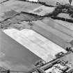
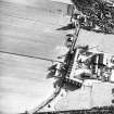
On-line Digital Images |
SC 1695021 |
RCAHMS Aerial Photography |
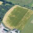
Windhill, oblique aerial view, taken from the NNE, centred on the cropmarks of a ring-ditch and a possible pit-circle. |
26/7/1995 |
Item Level |
|
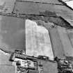 |
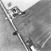
On-line Digital Images |
SC 1695022 |
RCAHMS Aerial Photography |
Windhill, oblique aerial view, taken from the NW, centred on the cropmarks of a ring-ditch and a possible pit-circle. |
26/7/1995 |
Item Level |
|
 |
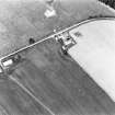
On-line Digital Images |
SC 1695039 |
RCAHMS Aerial Photography |
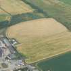
Windhill, oblique aerial view, taken from the S, centred on the cropmarks of a ring-ditch or pit-circle. |
16/7/1996 |
Item Level |
|
 |
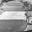
On-line Digital Images |
SC 1695040 |
RCAHMS Aerial Photography |
Windhill, oblique aerial view, taken from the SE, centred on the cropmarks of a ring-ditch or pit-circle. |
16/7/1996 |
Item Level |
|
 |
On-line Digital Images |
SC 1695041 |
RCAHMS Aerial Photography |
Windhill, oblique aerial view, taken from the NE, centred on the cropmarks of a ring-ditch or pit-circle. |
16/7/1996 |
Item Level |
|
 |
On-line Digital Images |
SC 1695129 |
RCAHMS Aerial Photography |
Oblique aerial view. |
1976 |
Item Level |
|
 |
On-line Digital Images |
SC 1695130 |
RCAHMS Aerial Photography |
Oblique aerial view. |
1976 |
Item Level |
|
 |
On-line Digital Images |
SC 1859721 |
RCAHMS Aerial Photography |
Windhill, oblique aerial view, taken from the NE, centred on the cropmarks of a ring-ditch and a possible pit-circle. A standing stone is visible in the top right-hand corner of the photograph. |
26/7/1995 |
Item Level |
|
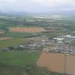 |
On-line Digital Images |
DP 340949 |
Papers of James Sloan Bone, landscape historian, Inverness, Highland, Scotland |
Aerial view of Muir of Ord, oblique view of industrial estate and part of Black Isle showground, looking NW. |
26/8/2007 |
Item Level |
|
 |
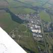
On-line Digital Images |
DP 340960 |
Papers of James Sloan Bone, landscape historian, Inverness, Highland, Scotland |
Aerial view of Tomich and Wyndhill Industrial Estates, S of Muir of Ord, Black Isle, looking SW. |
26/8/2007 |
Item Level |
|
 |
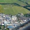
On-line Digital Images |
DP 343162 |
Papers of James Sloan Bone, landscape historian, Inverness, Highland, Scotland |
An oblique aerial view of Muir of Ordnear Muir of Ord, Black Isle, looking S. |
1/10/2013 |
Item Level |
|
 |
On-line Digital Images |
DP 343651 |
Papers of James Sloan Bone, landscape historian, Inverness, Highland, Scotland |
Near aerial view of Baxters, Tomich and Windhill Industrial Estates, Muir of Ord, Black Isle, looking SE. |
18/7/2018 |
Item Level |
|
 |
On-line Digital Images |
DP 343652 |
Papers of James Sloan Bone, landscape historian, Inverness, Highland, Scotland |
Near aerial view of enclosure cropmarks in field near Windhill, Muir of Ord, Black Isle, looking SE. |
18/7/2018 |
Item Level |
|
 |
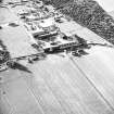
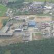
On-line Digital Images |
DP 343688 |
Papers of James Sloan Bone, landscape historian, Inverness, Highland, Scotland |
Oblique aerial view of part of the southern section of the industrial estate at Muir of Ord, Black Isle, looking E. |
23/7/2008 |
Item Level |
|
 |
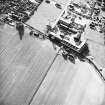
On-line Digital Images |
DP 343689 |
Papers of James Sloan Bone, landscape historian, Inverness, Highland, Scotland |
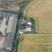
Near aerial view of the ring ditch at Windhill, Muir of Ord, Black Isle. |
23/7/2008 |
Item Level |
|
 |
On-line Digital Images |
SC 2362495 |
Records of the Ordnance Survey, Southampton, Hampshire, England |
Windhill, NH54NW 21, Ordnance Survey index card, page number 1, Recto |
1958 |
Item Level |
|
 |
On-line Digital Images |
SC 2362496 |
Records of the Ordnance Survey, Southampton, Hampshire, England |
Windhill, NH54NW 21, Ordnance Survey index card, Recto |
1958 |
Item Level |
|


