|
Photographs and Off-line Digital Images |
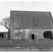
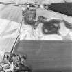
A 54955 |
Records of the Ordnance Survey, Southampton, Hampshire, England |
General view |
1975 |
Item Level |
|
|
Photographs and Off-line Digital Images |
RC 635 |
A collection of photographs by M Gibb |
General view |
11/1965 |
Item Level |
|
 |
On-line Digital Images |
SC 400712 |
Records of the Ordnance Survey, Southampton, Hampshire, England |
General view |
1975 |
Item Level |
|
|
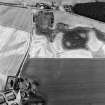
Photographs and Off-line Digital Images |
C 52846 |
RCAHMS Aerial Photography |
Gilchrist, oblique aerial view, taken from the E, centred on the cropmarks of a promontory fort. Kilchrist Church is visible in the bottom left-hand corner of the photograph. |
26/7/1995 |
Item Level |
|
|
Photographs and Off-line Digital Images |
C 52848 |
RCAHMS Aerial Photography |
Gilchrist, oblique aerial view, taken from the NW, centred on the cropmarks of a promontory fort. Kilchrist Church is visible in the top left-hand corner of the photograph. |
26/7/1995 |
Item Level |
|
|
Photographs and Off-line Digital Images |
C 52849 |
RCAHMS Aerial Photography |
Gilchrist, oblique aerial view, taken from the WNW, centred on the cropmarks of a promontory fort. Kilchrist Church is visible in the top right-hand corner of the photograph. |
26/7/1995 |
Item Level |
|
 |
On-line Digital Images |
SC 919478 |
RCAHMS Aerial Photography |
Gilchrist, oblique aerial view, taken from the E, centred on the cropmarks of a promontory fort. Kilchrist Church is visible in the bottom left-hand corner of the photograph. |
26/7/1995 |
Item Level |
|
|
Photographs and Off-line Digital Images |
D 74288 |
RCAHMS Aerial Photography |
Oblique aerial view centred on the cropmarks of the possible pit-defined enclosure, pits, linear cropmarks and promontory fort with church, mausoleum and cemetery adjacent, taken from the SSW. |
17/7/2000 |
Item Level |
|
|
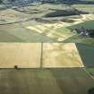
Photographs and Off-line Digital Images |
D 74290 |
RCAHMS Aerial Photography |
Oblique aerial view centred on the cropmarks of the possible pit-defined enclosure, pits, linear cropmarks and promontory fort with church, mausoleum and cemetery adjacent, taken from the SW. |
17/7/2000 |
Item Level |
|
|
Photographs and Off-line Digital Images |
D 74291 |
RCAHMS Aerial Photography |
Oblique aerial view centred on the cropmarks of the possible pit-defined enclosure, pits, linear cropmarks and promontory fort with church, mausoleum and cemetery adjacent, taken from the W. |
17/7/2000 |
Item Level |
|
|
Photographs and Off-line Digital Images |
D 74293 |
RCAHMS Aerial Photography |
Oblique aerial view centred on the cropmarks of the possible pit-defined enclosure, pits, linear cropmarks and promontory fort with church, mausoleum and cemetery adjacent, taken from the WNW. |
17/7/2000 |
Item Level |
|
|
Photographs and Off-line Digital Images |
D 74294 |
RCAHMS Aerial Photography |
Oblique aerial view centred on the cropmarks of the possible pit-defined enclosure, pits, linear cropmarks and promontory fort with church, mausoleum and cemetery adjacent, taken from the NW. |
17/7/2000 |
Item Level |
|
|
Photographs and Off-line Digital Images |
D 74295 |
RCAHMS Aerial Photography |
Oblique aerial view centred on the cropmarks of the possible pit-defined enclosure, pits, linear cropmarks and promontory fort with church, mausoleum and cemetery adjacent, taken from the NW. |
17/7/2000 |
Item Level |
|
|
Photographs and Off-line Digital Images |
E 98536 CS |
RCAHMS Aerial Photography |
Oblique aerial view centred on the cropmarks of the possible pit-defined enclosure, pits, linear cropmarks and promontory fort with church, mausoleum and cemetery adjacent, taken from the SW. |
17/7/2000 |
Item Level |
|
|
Photographs and Off-line Digital Images |
E 98537 CS |
RCAHMS Aerial Photography |
Oblique aerial view centred on the cropmarks of the possible pit-defined enclosure, pits, linear cropmarks and promontory fort with church, mausoleum and cemetery adjacent, taken from the SW. |
17/7/2000 |
Item Level |
|
|
Photographs and Off-line Digital Images |
D 69485 CN |
RCAHMS Aerial Photography |
Oblique aerial view centred on the cropmarks of the possible pit-defined enclosure, pits, linear cropmarks and promontory fort with church, mausoleum and cemetery adjacent, taken from the WSW. |
17/7/2000 |
Item Level |
|
|
Photographs and Off-line Digital Images |
D 69487 CN |
RCAHMS Aerial Photography |
Oblique aerial view centred on the cropmarks of the possible pit-defined enclosure, pits, linear cropmarks and promontory fort with church, mausoleum and cemetery adjacent, taken from the WNW. |
17/7/2000 |
Item Level |
|
|
Photographs and Off-line Digital Images |
D 69488 CN |
RCAHMS Aerial Photography |
Oblique aerial view centred on the cropmarks of the possible pit-defined enclosure, pits, linear cropmarks and promontory fort with church, mausoleum and cemetery adjacent, taken from the N. |
17/7/2000 |
Item Level |
|
|
Photographs and Off-line Digital Images |
D 69489 CN |
RCAHMS Aerial Photography |
Oblique aerial view centred on the cropmarks of the possible pit-defined enclosure, pits, linear cropmarks and promontory fort with church, mausoleum and cemetery adjacent, taken from the NE. |
17/7/2000 |
Item Level |
|
|
Photographs and Off-line Digital Images |
D 69490 CN |
RCAHMS Aerial Photography |
Oblique aerial view centred on the cropmarks of the possible pit-defined enclosure, pits, linear cropmarks and promontory fort with church, mausoleum and cemetery adjacent, taken from the ENE. |
17/7/2000 |
Item Level |
|
 |
On-line Digital Images |
SC 1029397 |
RCAHMS Aerial Photography |
Oblique aerial view centred on the cropmarks of the possible pit-defined enclosure, pits, linear cropmarks and promontory fort with church, mausoleum and cemetery adjacent, taken from the WSW. |
17/7/2000 |
Item Level |
|
|
Photographs and Off-line Digital Images |
J 11824 CS |
Papers of Professor Geraint Dyfed Barri Jones, archaeologist, Manchester, England |
Oblique aerial view |
26/7/1995 |
Item Level |
|
 |
On-line Digital Images |
SC 1551984 |
Papers of Professor Geraint Dyfed Barri Jones, archaeologist, Manchester, England |
Oblique aerial view |
26/7/1995 |
Item Level |
|
 |
On-line Digital Images |
SC 1695023 |
RCAHMS Aerial Photography |
Gilchrist, oblique aerial view, taken from the E, centred on the cropmarks of a promontory fort. Kilchrist Church is visible in the bottom left-hand corner of the photograph. |
26/7/1995 |
Item Level |
|


