
Castle Hill, Muir Of Ord


Henge (Neolithic) - (Bronze Age)
Site Name Castle Hill, Muir Of Ord
Classification Henge (Neolithic) - (Bronze Age)
Alternative Name(s) Muir Of Ord Golf Course
Canmore ID 12670
Site Number NH54NW 12
NGR NH 52729 49715
Datum OSGB36 - NGR
Permalink http://canmore.org.uk/site/12670


- Council Highland
- Parish Urray (Ross And Cromarty)
- Former Region Highland
- Former District Ross And Cromarty
- Former County Ross And Cromarty
NH54NW 12 52729 49715
(NH 5273 4972) Fort (NR)
OS 6" map, Ross-shire, 2n ed., (1907).
Location formerly entered as NH 5273 4972.
A Class II henge with a mean measurement of the extreme diameters from crest to crest between 100' and 105'. The monument has been used as a green on the Muir of Ord golf course, and a short stretch of the NW arc of the ditch has been filled in. The wasting of the bank may also be due in some measure to mutilation, but the general state of preservation is moderate. The interior measures about 85' by about 65' and the two segments of the ditch about 18' in width and 4' in depth. The axis of the henge lies a little S of E and N of W. Seen by R J C Atkinson and classified as a henge.
A J Beaton 1883; A A Woodham 1955; R W Feachem 1963; Information from A A Woodham to OS 27 May 1965 and 3 June 1965.
A henge, as described above.
Resurveyed at 1:2500.
Visited by OS (R D) 10 January 1965
Castle Hill displays none of the characteristics of a normal henge monument; its classification as such should be treated with caution.
Visited by OS (A C), 8 May 1967
(Classified as Class II henge).
H A W Burl 1969.
(Classified as Hengi-form site).
G J Wainwright 1969.
Henge
Castle Hill [NAT]
OS (GIS) MasterMap, March 2011.
Field Visit (July 1979)
Castle Hill, Muir of Ord NH 527 497 NH54NW 12
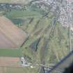
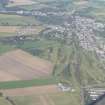
A Class II henge situated on Muir of Ord golf course, immediately W of the railway. It measures 25.5m by 19.5m within a ditch and external bank with opposed entrances on the WNW and ESE respectively.
RCAHMS 1979, visited July 1979
Woodham 1953, 76-7
Field Visit (May 2020)
NH 52724 49719 The opportunity to visit the golf course arose in the Spring of 2020 when it was closed to golfers but open to walkers during the Covid pandemic. Recent work has been done to remove the paths accessing the green and reinstate the turf. The visit was made with the purpose of carrying out a measured survey of the site and photographing it. The survey was executed using the taped offset method but because of the height discrepancy (c3m) it cannot be entirely accurate.
Archive: Highland Council HER, NRHE
Meryl Marshall
(Source: DES Vol 21)
Watching Brief (22 November 2022)
NH 52665 49700 An archaeological watching brief was undertaken in November 2022 for a small excavation for a bio-toilet on the Muir of Ord Golf Course, the site lying to the SW of Castle-Hill (NMRS) Canmore ID: 12670). No archaeological deposits or features were revealed.
Information from Stuart Farrell.

