|
Photographs and Off-line Digital Images |
B 88960 PO |
Copies of photographs by the Institute of Archaeology, London |
General view of crofting township. |
30/5/1936 |
Item Level |
|
|
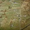
Photographs and Off-line Digital Images |
SC 695394 |
Copies of photographs by the Institute of Archaeology, London |
Daliburgh, South Uist, view of crofting township. Digital image B/88960/PO. |
30/5/1936 |
Item Level |
|
|
Photographs and Off-line Digital Images |
B 88958 PO |
Copies of photographs by the Institute of Archaeology, London |
View of unidentified ruined blackhouse. |
30/5/1936 |
Item Level |
|
|
Photographs and Off-line Digital Images |
B 88959 PO |
Copies of photographs by the Institute of Archaeology, London |
View of unidentified ruined blackhouse. |
30/5/1936 |
Item Level |
|
|
Photographs and Off-line Digital Images |
B 88961 PO |
Copies of photographs by the Institute of Archaeology, London |
General view of unidentified blackhouses. |
30/5/1936 |
Item Level |
|
|
Photographs and Off-line Digital Images |
B 88962 PO |
Copies of photographs by the Institute of Archaeology, London |
General view of unidentified blackhouses. |
30/5/1936 |
Item Level |
|
|
Photographs and Off-line Digital Images |
IN 2848 PO |
Copies of photographs by the Institute of Archaeology, London |
View of unidentified blackhouse. |
30/5/1936 |
Item Level |
|
|
Photographs and Off-line Digital Images |
IN 5734 |
List C Survey |
Distant view of unidentified blackhouses. |
1975 |
Item Level |
|
|
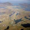
Photographs and Off-line Digital Images |
E 55386 CN |
RCAHMS Aerial Photography |
General oblique aerial view looking over the remains of the township, towards Lochboisdale and The Minch beyond, taken from the WNW. |
9/8/2005 |
Item Level |
|
|
Photographs and Off-line Digital Images |
E 55387 CN |
RCAHMS Aerial Photography |
General oblique aerial view looking over the remains of the township, towards Lochboisdale and The Minch beyond, taken from the W. |
9/8/2005 |
Item Level |
|
|
Photographs and Off-line Digital Images |
E 55388 CN |
RCAHMS Aerial Photography |
General oblique aerial view looking over the remains of the township, towards Lochboisdale and The Minch beyond, taken from the W. |
9/8/2005 |
Item Level |
|
|
Photographs and Off-line Digital Images |
E 55389 CN |
RCAHMS Aerial Photography |
Oblique aerial view centred on the remains of the township, taken from the ESE. |
9/8/2005 |
Item Level |
|
|
Photographs and Off-line Digital Images |
E 55390 CN |
RCAHMS Aerial Photography |
Oblique aerial view centred on the remains of the township, taken from the WNW. |
9/8/2005 |
Item Level |
|
|
Photographs and Off-line Digital Images |
E 55391 CN |
RCAHMS Aerial Photography |
Oblique aerial view centred on the remains of the township, taken from the W. |
9/8/2005 |
Item Level |
|
 |
On-line Digital Images |
SC 991670 |
RCAHMS Aerial Photography |
General oblique aerial view looking over the remains of the township, towards Lochboisdale and The Minch beyond, taken from the W. |
9/8/2005 |
Item Level |
|
 |
On-line Digital Images |
SC 991671 |
RCAHMS Aerial Photography |
Oblique aerial view centred on the remains of the township, taken from the ESE. |
9/8/2005 |
Item Level |
|
 |
On-line Digital Images |
SC 991673 |
RCAHMS Aerial Photography |
Oblique aerial view centred on the remains of the township, taken from the W. |
9/8/2005 |
Item Level |
|
|
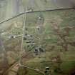
Photographs and Off-line Digital Images |
E 63799 CN |
RCAHMS Aerial Photography |
Oblique aerial view centred on the crofting township and the remains of the buildings, taken from the NNW. |
24/4/2005 |
Item Level |
|
|
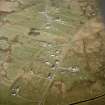
Photographs and Off-line Digital Images |
E 63800 CN |
RCAHMS Aerial Photography |
Oblique aerial view centred on the crofting township and the remains of the buildings, taken from the W. |
24/4/2005 |
Item Level |
|
|
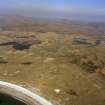
Photographs and Off-line Digital Images |
E 63813 CN |
RCAHMS Aerial Photography |
General oblique aerial view centred on the crofting township and the machair with Stulabhal in the distance, taken from the SW. |
24/4/2005 |
Item Level |
|
 |
On-line Digital Images |
SC 1009338 |
RCAHMS Aerial Photography |
General oblique aerial view centred on the crofting township and the machair with Stulabhal in the distance, taken from the SW. |
24/4/2005 |
Item Level |
|
 |
On-line Digital Images |
SC 1085548 |
RCAHMS Aerial Photography |
Oblique aerial view centred on the remains of the township, taken from the WNW. |
9/8/2005 |
Item Level |
|
|
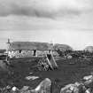
Photographs and Off-line Digital Images |
PA 243/22/3 |
Violet Banks |
View of a crofter's dwelling at Daliburgh South Uist |
c. 1920 |
Item Level |
|
 |
On-line Digital Images |
DP 050862 |
Violet Banks |
View of a crofter's dwelling at Daliburgh South Uist. |
1920 |
Item Level |
|


