
Yell, Windhouse


Broch (Iron Age)
Site Name Yell, Windhouse
Classification Broch (Iron Age)
Canmore ID 1256
Site Number HU49SE 4
NGR HU 4880 9191
Datum OSGB36 - NGR
Permalink http://canmore.org.uk/site/1256


- Council Shetland Islands
- Parish Yell
- Former Region Shetland Islands Area
- Former District Shetland
- Former County Shetland
HU49SE 4 4880 9191.
(HU 4880 9192) Brough (LB) (Site of)
OS 6" map, Shetland, 2nd ed., (1900).
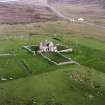
The remains of a broch ".... partly excavated many years ago when a number of typical objects, now lost, were recovered. Today the masonry is no more than two or three courses high, nor is there enough of it left to establish the ground-plan, but the overall diameter has been 53' 9". The wall is only 12' 9" thick on the north and NW. On the west, however, it expands to 15'4" and has contained a cell. This expansion may, as in other brochs, indicate the position of the entrance passage. An unusual feature is some slight buttressing of the outer face on the west and NW.
RCAHMS 1946, visited 1931.
The partially excavated remains of a broch, 17.5m in diameter, as generally described by the RCAHM. In the wall of an outbuilding immediately to the W, a shell midden is exposed.
Re-surveyed at 6" scale.
Visited by OS (NKB) 19 May 1969.
Publication Account (2002)
HU49 1 WINDHOUSE
HU/48809191
Probable broch on Yell I., on the shoulder of the hill overlooking the south end of Whale Firth and less than 30m above the sea. The site was excavated many years before the Commission's visit in 1931 when some 'typical' artefacts were found, but which are now lost. There are only two or three courses of masonry left but they show that the building has an overall diameter of 17.5m (57 ft. 4 ins.) and that the wall is 3.89 m (12 ft. 9 ins.) thick on the north and north-west. On the west however it expands to 4.68 m (15 ft. 4 ins.) and shows traces of an intra-mural cell. In the wall of an outbuilding immediately to the west a shell midden is exposed [1].
Sources: 1. OS card HU 49 SE 4: 2. RCAHMS 1946, vol. 3, no. 1723, 163.
E W MacKie 2002

