
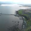
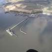
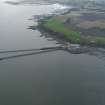
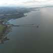
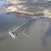
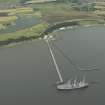
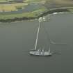
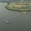
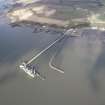
Charlestown, Royal Naval Armament Depot, Crombie, Crombie Pier


Pier (First World War), Pier (20th Century), Pier (Second World War)
Site Name Charlestown, Royal Naval Armament Depot, Crombie, Crombie Pier
Classification Pier (First World War), Pier (20th Century), Pier (Second World War)
Alternative Name(s) Rnad Crombie; River Forth; Crombie Pier; Inner Firth Of Forth
Canmore ID 125404
Site Number NT08SW 104.01
NGR NT 04839 83332
NGR Description NT 0484 8331 to NT 0473 8395
Datum OSGB36 - NGR
Permalink http://canmore.org.uk/site/125404


- Council Fife
- Parish Torryburn
- Former Region Fife
- Former District Dunfermline
- Former County Fife
NT08SW 104.01 from 0484 8331 to 0473 8395
Travelling crane annotated on OS digital maps on the pierhead may have been removed.

