 |
On-line Digital Images |
DP 016489 |
|
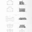
Engraving of elevation and plan inscr: ''Highland Churches and Manses.'' Includes plans, and elevations of church, one storey manse, and two storey manse. |
c. 1838 |
Item Level |
|
 |
On-line Digital Images |
DP 018803 |
|
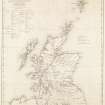
Engraving of map inscr: ''Map of Scotland shewing The Highland Roads and Bridges made, the Harbours improved and Churches built in the Highlands, also the Glasgow and Lanarkshire Roads, all according to the Plans of Thomas Telford. Shewing also the Old Military Roads still maintained in use.'' |
c. 1838 |
Item Level |
|
 |
On-line Digital Images |
DP 024743 |
RCAHMS Aerial Photography Digital |
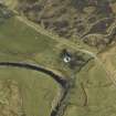
Oblique aerial view centred on the church and the remains of the broch with the manse adjacent, taken from the ESE. |
3/4/2007 |
Item Level |
|
 |
On-line Digital Images |
DP 024748 |
RCAHMS Aerial Photography Digital |
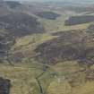
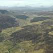
General oblique aerial view looking along Strath Cuileamach centred on the church, manse and remains of the broch, taken from the E. |
3/4/2007 |
Item Level |
|
 |
On-line Digital Images |
DP 024749 |
RCAHMS Aerial Photography Digital |
General oblique aerial view looking along Strath Cuileamach with the church, manse and remains of the broch in the foreground, taken from the SE. |
3/4/2007 |
Item Level |
|
 |
On-line Digital Images |
SC 1643902 |
List C Survey |
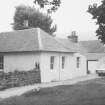
General view |
1975 |
Item Level |
|
 |
On-line Digital Images |
SC 1643903 |
List C Survey |
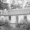
General view |
1975 |
Item Level |
|
 |
On-line Digital Images |
SC 2362029 |
Records of the Ordnance Survey, Southampton, Hampshire, England |
Croick, The Old Manse, NH49SE 7, Ordnance Survey index card, Recto |
1958 |
Item Level |
|


