
Unst, Framgord


House (Norse)
Site Name Unst, Framgord
Classification House (Norse)
Alternative Name(s) Priest's House
Canmore ID 125
Site Number HP60SW 24
NGR HP 61873 02956
Datum OSGB36 - NGR
Permalink http://canmore.org.uk/site/125


- Council Shetland Islands
- Parish Unst
- Former Region Shetland Islands Area
- Former District Shetland
- Former County Shetland
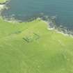
HP60SW 24 6186 0296
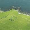
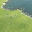
At HP 6186 0298 are the turf-covered footings of a rectangular building with its long axis down a slope, apparently a Norse type house. It is about 25.0m long and varies in width from 4.5m at the NW end to 5.2m at the SE end, over walls 0.5m maximum height. The NW end is higher than the other and the change in level probably denotes a cross wall. The SE end is indefinite.
Nearby are several walls, clearance heaps and cultivation terraces, many of them modern, but some undoubtedly associated.
Surveyed at 1/10,000.
Visited by OS (RL) 4 May 1969.

