 |
On-line Digital Images |
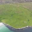
DP 082037 |
RCAHMS Aerial Photography Digital |
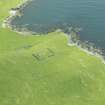
Oblique aerial view of the farmsteads, field systems and Framgord chapel, looking NW. |
15/6/2010 |
Item Level |
|
 |
On-line Digital Images |
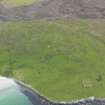
DP 082038 |
RCAHMS Aerial Photography Digital |
Oblique aerial view of the farmsteads, field systems and Framgord chapel, looking WNW. |
15/6/2010 |
Item Level |
|
 |
On-line Digital Images |
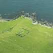
DP 197274 |
RCAHMS Aerial Photography Digital |
Oblique aerial view of Framgord Chapel, Sandwick, looking NW. |
15/8/2014 |
Item Level |
|
 |
On-line Digital Images |
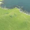
DP 197275 |
RCAHMS Aerial Photography Digital |
Oblique aerial view of Framgord Chapel, Sandwick, looking NW. |
15/8/2014 |
Item Level |
|
 |
On-line Digital Images |
DP 197276 |
RCAHMS Aerial Photography Digital |
Oblique aerial view of Framgord Chapel, Sandwick, looking NW. |
15/8/2014 |
Item Level |
|
 |
On-line Digital Images |
SC 2336240 |
Records of the Ordnance Survey, Southampton, Hampshire, England |
Unst, Framgord, HP60SW 24, Ordnance Survey index card, Recto |
1958 |
Item Level |
|
 |
On-line Digital Images |
SC 2336241 |
Records of the Ordnance Survey, Southampton, Hampshire, England |
Unst, Framgord, HP60SW 24, Ordnance Survey index card, Recto |
1958 |
Item Level |
|
|
All Other |
551 166/1/1 |
Records of the Ordnance Survey, Southampton, Hampshire, England |
Archaeological site card index ('495' cards) |
1947 |
Sub-Group Level |
|


