
Milton Bank


Building(S) (Post Medieval), Cairnfield (Post Medieval), Corn Drying Kiln (Post Medieval)(Possible), Enclosure(S) (Post Medieval), Manse (Post Medieval), Stack Yard (Post Medieval)
Site Name Milton Bank
Classification Building(S) (Post Medieval), Cairnfield (Post Medieval), Corn Drying Kiln (Post Medieval)(Possible), Enclosure(S) (Post Medieval), Manse (Post Medieval), Stack Yard (Post Medieval)
Canmore ID 124607
Site Number NC70SW 127
NGR NC 7388 0331
Datum OSGB36 - NGR
Permalink http://canmore.org.uk/site/124607


- Council Highland
- Parish Rogart
- Former Region Highland
- Former District Sutherland
- Former County Sutherland
Field Visit (5 July 1995)
NC70SW 127 7388 0331
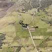
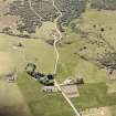
A manse, three other buildings, a possible kiln, six enclosures and an area of small cairns lie in pasture to the east of Rogart manse.
The manse (ROG95 831) comprises a cellared main range with two projecting wings, which partially enclose a yard. The main range has two compartments and measures 14.2m from NW to SE by 6.1m transversely over mortared-rubble walls 0.8m thick now reduced to 0.15m in height. A cellar, about 4.5m square, lies at the NW end of the building. The NW wing extends 7m from NE to SW by 7.3m overall and the SE wing 17.2m by 5.3m.
The rest of the buildings are severely robbed and range from 9.3m to 21.4m in length by 5.8m to 6.4m transversely over faced-rubble footings 0.8m to 0.9m thick and up to 0.4m high (ROG95 832, 842-3). Adjacent to one of the buildings (ROG95 842) there is a sheepfold and an enclosure to the ESE; the latter contains fourteen stack-stands, which measure about 3.7m in iameter.
What may be a corn-drying kiln (ROG95 841, NC 7388 0331) is levelled into the hill-slope; the bowl measures 3m in diameter within a rubble-faced bank 2.3m thick and 0.75m deep, with what may be a flue opening on the WNW.
A large group of small cairns (NC 7403 0328), which lies on the S-face of the hill behind Rogart Manse, extends for about 350m from NE to SW by about 100m transversely. The cairns measure up to 7.5m in diameter by 0.75m in height.
(ROG95 844)
The Manse is depicted as roofed on an estate map of 1811 (National Library of Scotland Deposit 313/3591/2); four further buildings and an enclosure are also depicted, of which two may have been detected at the date of survey: that beside the enclosure with the stack stands (ROG95 842), and that to the SE of the Manse (ROG95 843). The Manse and a building to the S (ROG95 832) are depicted as roofed on the 1st edition of the OS 6-inch map, but the 2nd edition shows the manse as unroofed (Sutherland 1879 and 1907, sheet civ).
(ROG95 841-4, 831-2)
Visited by RCAHMS (PJD) 5 July 1995

