 |
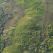
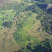
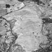
On-line Digital Images |
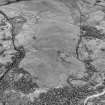
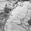
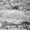
SC 503654 |
Records of the Royal Commission on the Ancient and Historical Monuments of Scotland (RCAHMS), Edinbu |
Little Rogart, oblique aerial view, taken from the SE, showing an area defined as an archaeological landscape. |
|
Item Level |
|
 |
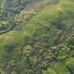
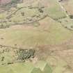
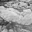
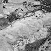
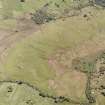
On-line Digital Images |
DP 080245 |
RCAHMS Aerial Photography Digital |
Oblique aerial view of Little Rogart, taken from the SSW. |
29/5/2009 |
Item Level |
|
 |
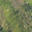
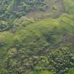
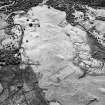
On-line Digital Images |
DP 080246 |
RCAHMS Aerial Photography Digital |
Oblique aerial view of Little Rogart, taken from the S. |
29/5/2009 |
Item Level |
|
 |
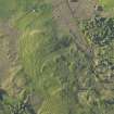
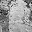
On-line Digital Images |
DP 080247 |
RCAHMS Aerial Photography Digital |
Oblique aerial view of Little Rogart, taken from the S. |
29/5/2009 |
Item Level |
|
 |
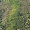
On-line Digital Images |
DP 080248 |
RCAHMS Aerial Photography Digital |
Oblique aerial view of Little Rogart, taken from the S. |
29/5/2009 |
Item Level |
|
 |
On-line Digital Images |
DP 080249 |
RCAHMS Aerial Photography Digital |
Oblique aerial view of Little Rogart, taken from the SSE. |
29/5/2009 |
Item Level |
|
 |
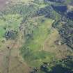
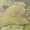
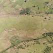
On-line Digital Images |
DP 080250 |
RCAHMS Aerial Photography Digital |
Oblique aerial view of the remains of the township of Little Rogart, Strathfleet, taken from the SE |
29/5/2009 |
Item Level |
|
 |
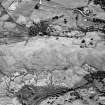
On-line Digital Images |
DP 080290 |
RCAHMS Aerial Photography Digital |
General oblique aerial view of Little Rogart, taken from the NNW. |
29/5/2009 |
Item Level |
|
 |
On-line Digital Images |
DP 080291 |
RCAHMS Aerial Photography Digital |
General oblique aerial view of Little Rogart, taken from the NNW. |
29/5/2009 |
Item Level |
|
 |
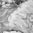
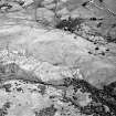
On-line Digital Images |
SC 1692916 |
RCAHMS Aerial Photography |
Little Rogart, oblique aerial view, taken from the E, showing an area defined as an archaeological landscape. |
23/6/1995 |
Item Level |
|
 |
On-line Digital Images |
SC 1692917 |
RCAHMS Aerial Photography |
Little Rogart, oblique aerial view, taken from the NNW, showing an area defined as an archaeological landscape. |
23/6/1995 |
Item Level |
|
 |
On-line Digital Images |
SC 1692962 |
RCAHMS Aerial Photography |
Little Rogart, oblique aerial view, taken from the S, showing an area defined as an archaeological landscape. |
23/6/1995 |
Item Level |
|
 |
On-line Digital Images |
SC 1692963 |
RCAHMS Aerial Photography |
Little Rogart, oblique aerial view, taken from the S, showing an area defined as an archaeological landscape. |
23/6/1995 |
Item Level |
|
 |
On-line Digital Images |
SC 1692964 |
RCAHMS Aerial Photography |
Little Rogart, oblique aerial view, taken from the NE, showing an area defined as an archaeological landscape. |
23/6/1995 |
Item Level |
|
 |
On-line Digital Images |
SC 1692965 |
RCAHMS Aerial Photography |
Little Rogart, oblique aerial view, taken from the N, showing an area defined as an archaeological landscape. |
23/6/1995 |
Item Level |
|
 |
On-line Digital Images |
SC 1692966 |
RCAHMS Aerial Photography |
Little Rogart, oblique aerial view, taken from the NW, showing an area defined as an archaeological landscape. |
23/6/1995 |
Item Level |
|
 |
On-line Digital Images |
SC 1692967 |
RCAHMS Aerial Photography |
Little Rogart, oblique aerial view, taken from the NW, showing an area defined as an archaeological landscape. |
23/6/1995 |
Item Level |
|
 |
On-line Digital Images |
SC 1692968 |
RCAHMS Aerial Photography |
Little Rogart, oblique aerial view, taken from the NW, showing an area defined as an archaeological landscape. |
23/6/1995 |
Item Level |
|
 |
On-line Digital Images |
SC 1692969 |
RCAHMS Aerial Photography |
Little Rogart, oblique aerial view, taken from the NW, showing an area defined as an archaeological landscape. |
23/6/1995 |
Item Level |
|
 |
On-line Digital Images |
SC 1692970 |
RCAHMS Aerial Photography |
Little Rogart, oblique aerial view, taken from the WNW, showing an area defined as an archaeological landscape. |
23/6/1995 |
Item Level |
|
 |
On-line Digital Images |
SC 1692971 |
RCAHMS Aerial Photography |
Little Rogart, oblique aerial view, taken from the WSW, showing an area defined as an archaeological landscape. |
23/6/1995 |
Item Level |
|
 |
On-line Digital Images |
SC 1692972 |
RCAHMS Aerial Photography |
Little Rogart, oblique aerial view, taken from the SW, showing an area defined as an archaeological landscape. |
23/6/1995 |
Item Level |
|
 |
On-line Digital Images |
SC 1693178 |
RCAHMS Aerial Photography |
Little Rogart, oblique aerial view, taken from the NW, showing an area defined as an archaeological landscape. |
23/6/1995 |
Item Level |
|
 |
On-line Digital Images |
SC 1693179 |
RCAHMS Aerial Photography |
Little Rogart, oblique aerial view, taken from the W, showing an area defined as an archaeological landscape. |
23/6/1995 |
Item Level |
|


