
Little Rogart


Corn Drying Kiln (Post Medieval), Rig And Furrow (Medieval) - (Post Medieval), Township (Post Medieval)
Site Name Little Rogart
Classification Corn Drying Kiln (Post Medieval), Rig And Furrow (Medieval) - (Post Medieval), Township (Post Medieval)
Canmore ID 124409
Site Number NC70SW 106.01
NGR NC 7325 0340
Datum OSGB36 - NGR
Permalink http://canmore.org.uk/site/124409


- Council Highland
- Parish Rogart
- Former Region Highland
- Former District Sutherland
- Former County Sutherland
Field Visit (6 July 1995)
NC70SW 106.01 7325 0340
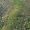
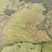
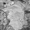
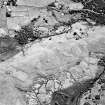
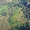
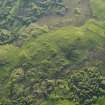
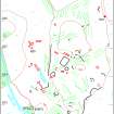
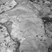
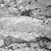
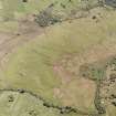
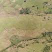
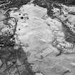
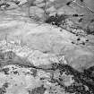
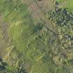
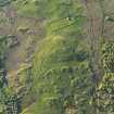
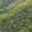
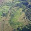
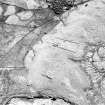
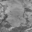
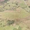
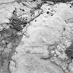
This township, which occupies a low grassy ridge largely surrounded by boggy ground, extends over a distance of about 850m from N to S by 350m transversely and comprises twenty-two buildings, five corn-drying kilns or kiln-barns, rig, a head-dyke, and some clearance heaps.
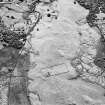
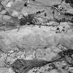
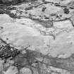
The buildings, which are disposed in three main clusters, are in many cases very much reduced and robbed, but evidently were once stone-walled or stone-based structures. They range from 4.4m to 28.4m in length by 2.9m to 5.9m in breadth over walls which, where best-preserved, are of faced-rubble, 0.6m to 0.8m thick and 0.9m high (ROG95 868), elsewhere they survive as stony banks 1.2m thick and up to 0.3m high. Six of the buildings are over 15m in length (ROG95 850, 852, 858, 862, 866, 875), typical of long byre-houses found elsewhere in Sutherland. The degree of robbing made it difficult to determine the internal arrangements - seven displayed evidence for an entrance in one side, and one may have had an entrance in the end wall (ROG95 870); two buildings were divided into two compartments (ROG95 852, 863), two into three (ROG95 866, 875), whilst four had outshots or extensions (ROG95 852, 862-3, 881); byre-drains were observed in three of the longer buildings (ROG95 858, 862, 866), and what may be a sump in a fourth (ROG95 875). In two cases the drains were situated on one side of the lower compartment (ROG95 858, 862) but, in the other, the drain ran down the centre of the compartment, which is where the sump is visible in the fourth building.
Of the five corn-drying kilns, one was too damaged for the kiln to be measured (ROG95 872), but the others ranged from 1.7m to 2.2m in diameter within rubble-faced walls 1.2m to 1.9m in thickness and 0.4m to 0.8m in depth. One is accompanied by a barn, measuring 3.5m by 2.6m, into which the kiln flue opens (ROG95 871), another has a platform 1.8m across in front of the flue (ROG95 860), whilst a third has has what may be a loading platform on the upslope side from the flue (ROG95 879).
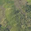
With the exception of some rocky outcrops and steep slopes that do not lend themselves to ploughing, the grassy ridge occupied by the township, an area of about 16.9ha, displays evidence of broad rig cultivation.
This area matches quite closely the extent of cultivation depicted on an estate map of 1811 (National Library of Scotland Deposit 313/359/1/2). The ridging is arranged in rough furlongs, which measure up to 120m in length with a maximum of six adjacent ridges. The ridges are high-backed, vary in width according to the terrain and may be quite sinuous, but where the ground is even, and consequently the ridges are most regular (e.g. NC 7320 0327), a width of about 6m-7m is typical, up to a maximum of about 9m. Headlands are also visible in a number of instances. Although no head-dyke is evident around the whole of the township, there are lengths of bank delimiting part of the S end of the area, of which one may be that depicted on the 1811 map (NC 7317 0315 to NC 7325 0306), but in the main the limit of the cultivated land is defined by a lynchet. Some clearance heaps are visible scattered amongst the ridges and at the N end of the site there are a number of banks or rickles of stone that form small plots or fields that may predate the rig. The plots are about 20m-40m in breadth, but none are complete enough to be sure of their overall layout and size, due to the exigencies of the rig cultivation.
An estate plan of 1811 depicts the township shortly before clearance (NLS Dep. 313/3591/2). Whilst most of the buildings that are shown were located during the survey, the site of one, which lay within the stone-walled field of the nineteenth century farm (NC70SW 106.02), was probably levelled by cultivation, and the sites of three others could not be satisfactorily identified on the date of survey. Little Rogart was occupied by David Sutherland and two other tenants in the Hearth Tax return of 1691 (SRO E69/23/1). In a rental of 1808 ten tenants were listed for 'Little Rogart and one-third of the shieling of Craigachnarich', and in 1815 'Little Rogart and an Improvement' had fourteen tenants (Adams 1972), but by 1828 the township must have been cleared, as it ceases to be listed in the rentals (NLS Dep. 313/2162), and it is not depicted on Burnett and Scott's map of Sutherland of 1833 (Burnett and Scott 1833).
(ROG95 849-853, 855-864, 866-868, 870-872, 875, 877, 879, 880-1, 883)
R J Adam 1972
G Burnett and W Scott 1833
Visited by RCAHMS (PJD) 6 July 1995

