|
Photographs and Off-line Digital Images |
C 9963 |
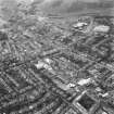
RCAHMS Aerial Photography |
Aerial view including Causewayside, Minto Street, Fountainhall Road, South Clerk Street, Salisbury Place seen from the South South West. |
1993 |
Item Level |
|
|
Photographs and Off-line Digital Images |
C 9962 |
RCAHMS Aerial Photography |
Aerial view including Causewayside, Minto Street, South Clerk Street, Salisbury Crags, Salisbury Place, West Preston Street seen from the South South West. |
1993 |
Item Level |
|
|
Print Room |
EPS INDEX |
Records of Edinburgh Photographic Society, Edinburgh, Scotland |
Photographic Survey of Edinburgh and District Ward XIV George Square.
With map of the district with lists of the streets surveyed.
This EPS collection contains 81 mounts bearing labelled and dated photographs and some engravings of buildings in this area, with the names of the photographers, mainly taken 1911-1914 with some earlier ones including copies of D.O. Hill's work. The survey includes Greyfriars Churchyard, Lawnmarket, Grassmarket, Lauriston, George Square etc. Purchased from Edinburgh Photographic Society by SNBR for £50, 1947. |
1839 |
Item Level |
|
|
Print Room |
EPS 40/2 |
Records of Edinburgh Photographic Society, Edinburgh, Scotland |
EPS/40/2 Photograph of South Clerk Street, West side, looking South from Hope Park Terrace/Bermard Terrace, showing Livingstone Halls.
Edinburgh Photographic Society Survey of Edinburgh and District, Ward XIV George Square. |
1914 |
Item Level |
|
|
Prints and Drawings |
DC 6630 |
General Collection |
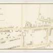
Plan of the area around Causewayside including Duncan Street, Upper Gray Street, Grange Road, Salisbury Place, Sciennes, Sciennes Place, West Preston Street, Newington Road, Summer Hall and part of the Meadows.
Insc. 'Plan of the Causewayside and its immediate neighbourhood shewing the slaughter houses at Grange Court. March 1850. Alfred Lancefield Surveyor. 11 Buccleuch Place Edinburgh.'
Insc. on the back of the drawing 'Plan of the Slaughter houses at the Causewayside Edinburgh by A Lancefield. Drawer 28 No. 28.' |
3/1850 |
Item Level |
|
|
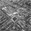
Photographs and Off-line Digital Images |
D 98003 S |
|
Oblique aerial view of Edinburgh, South Clerk Street taken in 1951. Bernard Terrace with C & J Browns furniture store (Now RCAHMS, John Sinclair House) visible on the right margin of the photograph. |
7/12/1951 |
Item Level |
|
|
Photographs and Off-line Digital Images |
E 21122 CN |
City of Edinburgh Council Architectural Drawings and Photographs |
Photographic copy of a plan of the area around Causewayside including Duncan Street, Upper Gray Street, Grange Road, Salisbury Place, Sciennes, Sciennes Place, West Preston Street, Newington Road, Summer Hall and part of the Meadows.
Insc. 'Plan of the Causewayside and its immediate neighbourhood shewing the slaughter houses at Grange Court. March 1850. Alfred Lancefield Surveyor. 11 Buccleuch Place Edinburgh.'
Insc. on the back of the drawing 'Plan of the Slaughter houses at the Causewayside Edinburgh by A Lancefield. Drawer 28 No. 28.' |
3/1850 |
Item Level |
|
|
Photographs and Off-line Digital Images |
E 21121 P |
City of Edinburgh Council Architectural Drawings and Photographs |
Photographic copy of a plan of the area around Causewayside including Duncan Street, Upper Gray Street, Grange Road, Salisbury Place, Sciennes, Sciennes Place, West Preston Street, Newington Road, Summer Hall and part of the Meadows.
Insc. 'Plan of the Causewayside and its immediate neighbourhood shewing the slaughter houses at Grange Court. March 1850. Alfred Lancefield Surveyor. 11 Buccleuch Place Edinburgh.'
Insc. on the back of the drawing 'Plan of the Slaughter houses at the Causewayside Edinburgh by A Lancefield. Drawer 28 No. 28.' |
3/1850 |
Item Level |
|
|
Print Room |
EPS 40 |
Records of Edinburgh Photographic Society, Edinburgh, Scotland |
Card folder containing photographs of Clerk Street, Hope Park Terrace, South Clerk Street and West Preston Street. Front cover has pencil notes describing the photographs inside.
Edinburgh Photographic Society Survey of Edinburgh District, Ward XIV George Square. |
1914 |
Item Level |
|
 |
On-line Digital Images |
DP 088651 |
Records of Edinburgh Photographic Society, Edinburgh, Scotland |
Card folder containing photographs of Clerk Street, Hope Park Terrace, South Clerk Street and West Preston Street. Front cover has pencil notes describing the photographs inside.
Edinburgh Photographic Society Survey of Edinburgh District, Ward XIV George Square. |
1914 |
Item Level |
|
 |
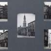
On-line Digital Images |
SC 1241948 |
Records of Edinburgh Photographic Society, Edinburgh, Scotland |
Photograph with text: 'South Clerk Street - looking South;
Edinburgh Photographic Society Survey of Edinburgh and District, Ward XIV George Square |
1914 |
Item Level |
|
 |
On-line Digital Images |
DP 140195 |
General Collection |
Plan of the area around Causewayside including Duncan Street, Upper Gray Street, Grange Road, Salisbury Place, Sciennes, Sciennes Place, West Preston Street, Newington Road, Summer Hall and part of the Meadows.
Insc. 'Plan of the Causewayside and its immediate neighbourhood shewing the slaughter houses at Grange Court. March 1850. Alfred Lancefield Surveyor. 11 Buccleuch Place Edinburgh.'
Insc. on the back of the drawing 'Plan of the Slaughter houses at the Causewayside Edinburgh by A Lancefield. Drawer 28 No. 28.' |
3/1850 |
Item Level |
|
|
Photographs and Off-line Digital Images |
SC 1381550 |
|
Photographic copy of a plan of the area around Causewayside including Duncan Street, Upper Gray Street, Grange Road, Salisbury Place, Sciennes, Sciennes Place, West Preston Street, Newington Road, Summer Hall and part of the Meadows.
Insc. 'Plan of the Causewayside and its immediate neighbourhood shewing the slaughter houses at Grange Court. March 1850. Alfred Lancefield Surveyor. 11 Buccleuch Place Edinburgh.'
Insc. on the back of the drawing 'Plan of the Slaughter houses at the Causewayside Edinburgh by A Lancefield. Drawer 28 No. 28.' |
3/1850 |
Item Level |
|
 |
On-line Digital Images |
SC 1677894 |
RCAHMS Aerial Photography |
Aerial view including Causewayside, Minto Street, South Clerk Street, Salisbury Crags, Salisbury Place, West Preston Street seen from the South South West. |
1993 |
Item Level |
|
 |
On-line Digital Images |
SC 1677895 |
RCAHMS Aerial Photography |
Aerial view including Causewayside, Minto Street, Fountainhall Road, South Clerk Street, Salisbury Place seen from the South South West. |
1993 |
Item Level |
|


