 |
On-line Digital Images |
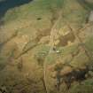
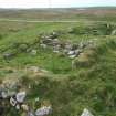
SC 1013935 |
RCAHMS Aerial Photography |
Oblique aerial view centred on the farmstead and the remains of the buildings, taken from the E. |
24/4/2005 |
Item Level |
|
 |
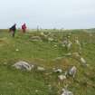
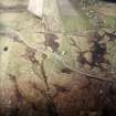
On-line Digital Images |
DP 150744 |
RCAHMS digital photography |
The building from the S of the road from the NE |
6/6/2012 |
Item Level |
|
 |
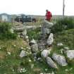
On-line Digital Images |
DP 150745 |
RCAHMS digital photography |
The entrance to the building S of the road from the SE |
6/6/2012 |
Item Level |
|
 |
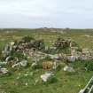
On-line Digital Images |
DP 150746 |
RCAHMS digital photography |
The building N of the road from the S |
6/6/2012 |
Item Level |
|
 |
On-line Digital Images |
DP 150747 |
RCAHMS digital photography |
The building N of the road from the N |
6/6/2012 |
Item Level |
|
 |
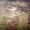
On-line Digital Images |
SC 1691136 |
RCAHMS Aerial Photography |
Oblique aerial view centred on the farmstead and the remains of the buildings, taken from the SSE. |
24/4/2005 |
Item Level |
|
 |
On-line Digital Images |
SC 1691137 |
RCAHMS Aerial Photography |
Oblique aerial view centred on the radar station with the remains of the chambered cairn and aisled house adjacent, taken from the SSE. |
24/4/2005 |
Item Level |
|
 |
On-line Digital Images |
SC 1694092 |
RCAHMS Aerial Photography |
Oblique aerial view centred on the farmstead and the remains of the buildings, taken from the E. |
24/4/2005 |
Item Level |
|


