
North Uist, Gearraidh Na Beinne Baine


Cattlefold (19th Century), Farmstead (19th Century)
Site Name North Uist, Gearraidh Na Beinne Baine
Classification Cattlefold (19th Century), Farmstead (19th Century)
Canmore ID 123393
Site Number NF77SW 31
NGR NF 72548 71946
Datum OSGB36 - NGR
Permalink http://canmore.org.uk/site/123393


- Council Western Isles
- Parish North Uist
- Former Region Western Isles Islands Area
- Former District Western Isles
- Former County Inverness-shire
NF77SW 31 7255 7194
A farmstead comprising one unroofed, four roofed buildings and three enclosures is depicted on the 1st edition of the OS 6-inch map (Inverness-shire, Hebrides, North Uist etc. 1881, sheet xxxiii).
One roofed, one unroofed building and two enclosures are shown on the current edition of the OS 1:10000 map (1971).
Information from RCAHMS (SAH), 25 April 1997.
Field Visit (6 June 2012)
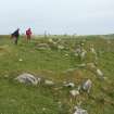
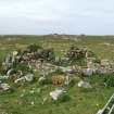
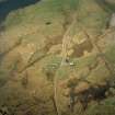
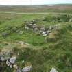
The footings of two buildings, formerly part of the farmstead of Gerraidh Na Beinne Baine, are situated close to the modern house and shed. Both are depicted roofed on the 1st edition of the OS 25-inch map (Invernessshire, North Uist, 1881, Sheet XXX.4), but unroofed on the 2nd edition of the map (1903).
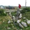
NF 72613 71934. This building stands on the N side of the public road 50m E of the present house. Rectangular on plan but with rounded corners, it measures about 13.5m from N to S by 6m transversely over low, grass-grown, roughly coursed rubble walls. It contains two compartments separated by a partition wall in which there is an entrance. The southern compartment and an outshot attached to the S end of the building each has an entrance on the E. A roughly square enclosure adjoins the W side of the building.
NF 72551 71913. The ruins of a small building stand 24m S of the modern house, on the N side of a large enclosure annotated ‘Cattlefold’ on the 1st edition map. It measures about 5m square over roughly coursed rubble walls up to 0.7m high, and there is an entrance on the S.
Visited by RCAHMS (JRS, ATW, IP), 6 June 2012.

