
Carn Daley


Chambered Cairn (Neolithic)
Site Name Carn Daley
Classification Chambered Cairn (Neolithic)
Canmore ID 12338
Site Number NH43SE 1
NGR NH 49454 31458
Datum OSGB36 - NGR
Permalink http://canmore.org.uk/site/12338


- Council Highland
- Parish Urquhart And Glenmoriston
- Former Region Highland
- Former District Inverness
- Former County Inverness-shire
NH43SE 1 49454 31458.
(NH 4944 3145) Cairn Daley (OE)
OS 6"map, Inverness-shire, 2nd ed., (1905)
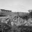
Carn Daley: Clava passage grave. The site has been much robbed and subsequently piled with field stones. The ploughing has come up to about the position of the monoliths, and a wall has been built along the NW edge.
The cairn has a diameter of 40 ft. The kerb of boulders is visible for about a third of the circuit on the S. side, and intermittently round the rest of the perimeter. On the SW by the entrance the line of the kerb is slightly flattened, and the boulders are 2 ft. 6in. to 1 ft. 6 in. high and of a considerable size. On the N and E only the very tops of a few kerb-stones are visible, and the cairn has been almost completely robbed behind them though its adge is still discernible as a slight bank. There is a considerable platform of cairn material between the kerb and the monoliths, but this is partly due to the way in which the monument has been ruined... The ring of monoliths outside the cairn is represented by one stone on the S. side, 2 ft. 9 ins. high, and the stump of a second on the NE...To the ESE the top of an acutely leaning slab is visible with its foot probably in situ; part of another stone which may have belonged to the circle lies to the S. of it, and a slab 5 ft. long lying to the S. of the entrance is probably a fifth monolith.' Visited 15.4.57.
The cairn was excavated by Inverness Scientific Society about 1900 but there is no record of the excavation.
A S Henshall 1963
This cairn is as described above.
Resurveyed at 1/2500.
Visited by OS (R D) 3 December 1964
Field Visit (17 August 1943)
This site was recorded as part of the RCAHMS Emergency Survey, undertaken by Angus Graham and Vere Gordon Childe during World War 2. The project archive has been catalogued during 2013-2014 and the material, which includes notebooks, manuscripts, typescripts, plans and photographs, is now available online.
Information from RCAHMS (GF Geddes) 12 November 2014.
Project (May 2001)
A project of archaeological survey and evaluation was undertaken for Team Aquarius, on behalf of NOSWA by Headland Archaeology in advance of a water mains pipeline along Glen Urquhart, Highland. The proposed route runs from Tomich (NH 314 277) north to Cannich (NH 334 318) and then east towards Drumnadrochit where it splits to the north (NH 502 332) and south (NH 498 283). The proposed route is largely along the roadside but four stretches are through farmland or forestry. The survey comprised an initial desk based assessment to examine all available documentary and map sources prior to commencement of fieldwork, a walkover survey of the entire route and a watching brief on six trial pits highlighted as being in archaeologically sensitive areas by Highland Council’s Planning and Development Department Archaeological Officer. A full specification for the archaeological work was prepared by Highland Council.
Headland Archaeology 2001

