
Cancelled


No Class (Period Unassigned)
Site Name Cancelled
Classification No Class (Period Unassigned)
Canmore ID 122824
Site Number NS87NW 4.02
NGR NS
Datum OSGB36 - NGR
Permalink http://canmore.org.uk/site/122824


- Council Falkirk
- Parish Falkirk
- Former Region Central
- Former District Falkirk
- Former County Stirlingshire
Excavation (1957)
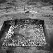
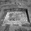
NS 8379 7980 and NS 8346 7980. When visited in 1957, the two 'expansions' were roughly semi-circular on plan, measuring about 10.0m E-W at the rampart face by 7.0m N-S, with a maximum height of 1.2m. The eastern expansion was excavated in 1957 by the RCAHMS who showed that it had been rectangular, and would have measured about 19' x 10' at a height of 10' above the ground (the estimated height of the rampart). It was formed of turf set on a stone base, the semi-circular appearance being due to the collapse of the weathered turfwork.
Considerations of siting and the discovery of burnt deposits of wood, turfwork and Roman pottery in the immediate vicinity of the eastern expansion indicate that they were beacon stances, communicating with the area N of the Wall.
K A Steer 1959; RCAHMS 1963, visited 1957.
Cancellation (5 March 2019)
This record has been cancelled as it duplicates and conflates the material assigned to records 46801 (Bonnyside East, formerly both), and 122823 (Bonnyside west).
Information from HES Survey and Recording (GFG) 5 March 2019

