
Pricing Change
New pricing for orders of material from this site will come into place shortly. Charges for supply of digital images, digitisation on demand, prints and licensing will be altered.
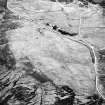
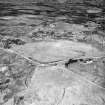
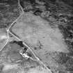
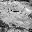
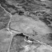
Achnahuie


Building (19th Century)
Site Name Achnahuie
Classification Building (19th Century)
Canmore ID 122697
Site Number NC70NW 135
NGR NC 7170 0719
Datum OSGB36 - NGR
Permalink http://canmore.org.uk/site/122697


- Council Highland
- Parish Rogart
- Former Region Highland
- Former District Sutherland
- Former County Sutherland
Field Visit (11 May 1995)
NC70NW 135 7170 0719
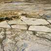
This rectangular, two-compartment building, which is situated in the angle between the public roads to the W of Achnahuie, measures 12.9m from WNW to ESE by 2.9m transversely within faced-rubble footings 0.7m in thickness and 0.4m in height. The 1st edition of the OS 6-inch map (Sutherland 1879, sheet xcvi) depicts the building as roofed, while by the date of the 2nd edition map (Sutherland 1907, sheet xcvi) it had become roofless.
(ROG95 299)
Visited by RCAHMS (DCC) 11 May 1995

