
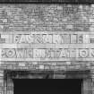
Fasnakyle Power Station


Hydroelectric Power Station (Modern)
Site Name Fasnakyle Power Station
Classification Hydroelectric Power Station (Modern)
Alternative Name(s) Affric/beauly Hydroelectric Scheme; Glen Affric
Canmore ID 12237
Site Number NH32NW 4
NGR NH 31867 29626
Datum OSGB36 - NGR
Permalink http://canmore.org.uk/site/12237


First 100 images shown. See the Collections panel (below) for a link to all digital images.
- Council Highland
- Parish Kilmorack
- Former Region Highland
- Former District Inverness
- Former County Inverness-shire
NH32NW 4.00 31867 29626
NH32NW 4.01 NH 3197 2997 Transformer Station
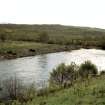
For associated Loch Beinn a' Mheadhoin reservoir and dam (centred NH 259 267). see NH22N4 5.00.
Fasnakyle Power Station [NAT]
OS 1:10,000 map, 1971.
Publication Account (2007)
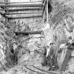
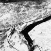
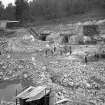
In 1928 and 1941 hydro-schemes were proposed in Glen Affric. The first was turned down by Parliament and the second was dropped in favour of the more comprehensive Mullardoch–Fasnakyle–Affric project which was approved in 1947 and officially opened in 1952. A further stage to the north, developing the water power resources of the Beauly and its tributaries, the Strathfarrar and Kilmorack scheme, was carried out from 1957–63 and included the impressive 113 ft high double curvature arch dam at Loch Monar.
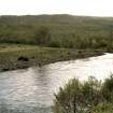
The main elements of the Affric scheme consist of Mullardoch Dam (NH23SW 1.00), a tunnel from Loch Mullardoch to Benevean, a small dam at Loch Benevean (NH22NE 5.01) and a tunnel from there to the main generating station at Fasnakyle in Strathglass (NH32NW 4.00).
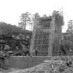
Mullardoch Dam is 157 ft high and 2385 ft long and, with about 300 000 cu. yards of concrete, is the largest concrete gravity dam in Great Britain. It has two wings meeting at an angle of 1408 with the apex pointing downstream. Construction began in 1947 and two years into the work it was decided to raise the height of the dam by 20 ft, a change requiring great skill in its execution.
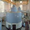
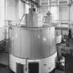
The dam has two spillways each 315 ft long and the level of the loch was raised by 112 ft to form a reservoir 8 1/2 miles long. Water from the reservoir is conveyed through a 14 1/2 ft diameter tunnel, 3 miles long, to Loch Benevean and onward to Fasnakyle Power Station where three 22 000kW
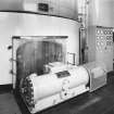
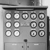
turbo alternators, with Francis-type turbines working under a gross head of about 520 ft, each develop 33 000 hp at 375 rpm.
The engineers were Sir William Halcrow & Partners and the main contractors, John Cochrane & Sons.
R Paxton and J Shipway, 2007.
Reproduced from 'Civil Engineering heritage: Scotland - Highlands and Islands' with kind permission from Thomas Telford Publishers.
Field Visit (2010)
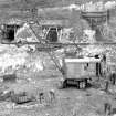
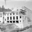
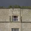
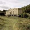
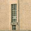
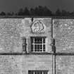
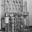
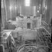
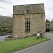
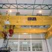
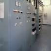
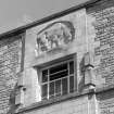
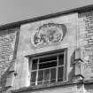
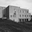
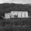
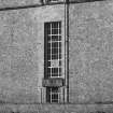
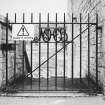
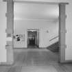
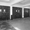
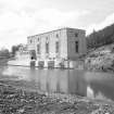
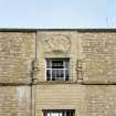
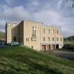
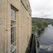
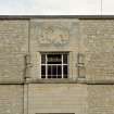
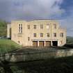
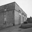
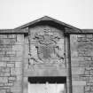
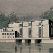
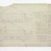
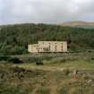
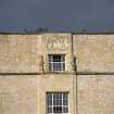
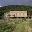
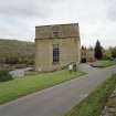
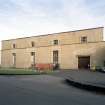
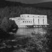
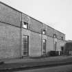
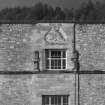
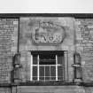
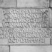
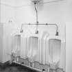
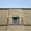
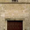
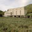
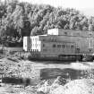
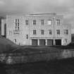
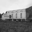
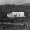
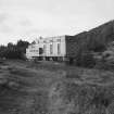
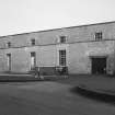
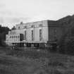
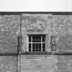
Fasnakyle power station receives water from the outfall from the Bennevean dam which is conveyed to the station by tunnel and steel pipe. The water is used to drive three recently refurbished turbines and a fourth later turbine in a later additional bay to the east end of the powerhouse. The station has a capacity of 69 megawatts. Originally designed as the control centre for the scheme, the station also includes a number of offices and workshops. Fasnakyle is an excellent example of a medium to large hydroelectric power station with an additional role as the control centre for a large scheme. The architectural detailing of the building is a good example of the delicate balance which was struck between functional and modernist styles. The design also makes a number of conscious references to its setting, in response to concerns about the impact it would have on scenic amenity in the area. The use of local stone for construction ties the building into the landscape, ensuring it merges with the surrounding topography. The window lintels on also contain carved panels, by Hew Lorimer, depicting a number of Pictish symbols clearly tying the building to local traditions and history. This combination of a desire to express the modernity of the sector and a requirement that buildings reference the traditions of their setting is clear in the overall design with a cubic modernist overall form and some modernist motif such as the large areas of glazing to the turbine hall combined with historical detailing to window surrounds and the use of coursed rubble. The end bay of the turbine hall is a later addition, housing an additional turbine and dates from c.2003. National Archives of Scotland (NAS), Ref: NSE North of Scotland Hydro Electric Board Collection (1943 -1990); NAS, Ref: NSE1 North of Scotland Hydro Electric Board Minutes (1943-1990); NAS, Ref NSE2 North of Scotland Hydro Electric Board Annual Reports (1943-1990); PL Payne, 1988; J Miller, 2002, 52: E Wood, 2002, 81, 88; S MacConnachie, Architectural Heritage, XIV, (2003); Scottish Hydro Electric, 2000, 12.
Note (25 October 2023)
The Affric/ Beauly scheme
The work was begun on the construction of Mullardoch Dam in 1947. This is of the mass gravity type and is 2385 feet in length by 160 feet in height, impounding 7.5 million cubic feet of water. A tunnel was excavated from Loch Mullardoch to Loch Benevan, and another from the latter loch to Fasnakyle, the main power station on the River Affric, both tunnels being over three miles in length. The Fasnakyle tunnel splits into three steel-lined tunnels near the power station, each supplying a 22,000kW vertical Francis turbo-alternator.
The second stage of the scheme involved the Rivers Farrar and Beauly. Water is impounded in Loch Monar by the Monar Dam, supplying the Deanie power station at the west end of Loch Bennacharan which is dammed at the east end to feed Culligran power station, whose outflow to the River Farrar then flows into the River Glass. These power stations generate 38MW and 24MW respectively. The River Glass flows into the River Beauly which has dams and power stations at Aigas and Kilmorack, each a 20MW run of river station. These dams are provided with flood control, Borland fish passes and compensation water facilities with or without generation. The scheme was completed in 1963.
Information from NRHE, catalogue item number WP007424 compiled by George Walker, 2005.

