
Dumbarton, Church Street, Sheriff Court


County Building (19th Century), Court House (19th Century), Pottery Scatter (Post Medieval)
Site Name Dumbarton, Church Street, Sheriff Court
Classification County Building (19th Century), Court House (19th Century), Pottery Scatter (Post Medieval)
Alternative Name(s) Courthouse; Dumbarton County Buildings
Canmore ID 121426
Site Number NS37NE 59
NGR NS 39821 75361
Datum OSGB36 - NGR
Permalink http://canmore.org.uk/site/121426


- Council West Dunbartonshire
- Parish Dumbarton
- Former Region Strathclyde
- Former District Dumbarton
- Former County Dunbartonshire
NS37NE 59 3981 7535
NS 398 753. The foundations of the early 19th-century Napoleonic prison, demolished in 1973, and associated ancillary structures and landscape features were located between September and December 2001 under compacted demolition rubble. Underlying the early 19th-century structures was a horticultural soil, no more than 0.2m deep, which contained pottery ranging from the 14th to the 17th century. The land was apparently used as open ground, perhaps an orchard, prior to the construction of the Court House and Prison.
Archive to be deposited in the NMRS.
Sponsor: Scottish Court Service.
D Sproat 2002.
NS37NE 59 39821 75361
NMRS REFERENCE:
DATES:
1824.
1862. Extensions by Spence architect.
1905. Further extensions by C.J. Halley.
NMRS Photographs
PSA Photograph Collection
G/8992/1-6 and Y/933/1 not held in NMRS negative store.
Publication Account (1996)
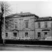
The court-house, which is now occupied by Dumbarton Sheriff Court, is situated on the E side of Church Street, about 300m ENE of the site of the old tolbooth in High Street. When first built in 1824-5, to a design by James Gillespie Graham, it occupied a spacious enclosure at the NE edge of the burgh, and a prison by the same architect stood 55m to the E. The court-house was extended in 1862 with flanking wings designed by William Spence, and was further extended to the rear in 1895 and 1898. The prison was enlarged in 1840, but went out of use in 1883 and was demolished, except for the round-arched entrance-doorway, in 1973.
The original building is two-storeyed and rectangular, measuring 19.5m across the main (W) front by 11.4m, while the lower wings of 1862 extended the frontage to 42m. The main front is of three bays, with a pedimented and advanced centrepiece and projecting end-plinths which support paired Ionic pilasters at the upper level. Similar pilasters frame the centre piece, and they carry a bold entablature and blocking course within which is set the hipped roof. The ground storey is faced with channelled ashlar, and the round-arched central doorway is enclosed by a pedimented Doric portico. The rectangular ground-floor windows are plain, but those at the upper level have recessed aprons below moulded sill-courses. The flanking ones have tall consoles supporting entablatures, and the central window is set in a round-headed recess, with a blind roundel in the tympanum.
In the original arrangement of the ground floor, the vestibule opened into a stair to the S and an office used by the county in the NW angle. To the NE was the office of the sheriff-clerk, and to the SE that of the town clerk, separated by two document-stores. These offices have been encroached on by a modern corridor, but they retain decorated cornices and tripartite windows with panelled architraves, and a barrel-vaulted store with a six-panelled iron door is entered from the NE room. The scale-and-plat stair, with its cast-iron balustrade, gives access to the first-floor court-room, which was originally shared by the burgh and county. This preserves its panel-fronted jury-box and a round-ended enclosure below the bench, whose front is flanked by timber Corinthian columns. At the S end, entered from the upper flight of the main stair, there is a gallery supported on Doric cast-iron pillars and with a decorative iron balustrade. Until 1862 the town council met in the room adjoining the court-room to the SE, but this has been much altered.
The added wings of 1862 have symmetrical three-bay W fronts in character with the original work. Their central round arched doorways have pilastered surrounds, and the wall-heads are balustraded. The N wing was reserved for county and sheriff-court use, while the town council was allocated meeting- and committee-rooms and a town clerk's office in the Swing. This area was extensively altered in the 1890s, when a large staircase was inserted.
HISTORY
The old tolbooth of 1642-5, which was demolished in 1832, stood on the N side of High Street on the site of an earlier building. It was three-storeyed, with a forestair to a roundarched doorway at the E end of the S front and an open belfry on the crow-stepped E gable. Until 1794 there were separate rooms for council meetings and the sheriff court, but the demands of space for prisoners led the council to transfer their meetings to the court-room.
By 1819 the tolbooth was insecure and beyond repair, and the town council requested financial assistance from the county for a new jail. After much negotiation it was agreed that the burgh would contribute £700 of an estimated cost of £3,500, and the value of the site and materials of the old building. In 1822 the Jail Committee considered alternative plans from Gillespie Graham, who strongly recommended the separation of the public buildings from the prison, and two years later his plans were adopted, with unspecified alterations by Robert Scott. The contractor was a local mason and councillor, Robert Campbell. The foundation-stone was laid with great ceremony in July 1824, and both buildings were completed in the following year.
In 1861 the county authorities and government decided to enlarge the court-house, and sketch-plans by the Glasgow architect William Spence were found so acceptable that a proposed competition was cancelled. The town council agreed to vacate the original building, in return for equivalent accommodation in the new Swing.
Information from ‘Tolbooths and Town-Houses: Civic Architecture in Scotland to 1833’ (1996).
Publication Account (1999)
The municipal buildings of the town are all of comparatively recent construction. The 83 tolbooth, which stood on the High Street near the market cross, was superseded by a new Courthouse figure 23.G and gaol complex figure 23.H on Church Street (constructed as the County Buildings, 1824-6). The gaol was demolished in 1973, during road reconstruction, although a few stones-most notably the Dumbarton burgh arms-remain built into a boundary wall. The Courthouse is strongly classical, with a pedimented porch and ionic pilasters and later additions, such as the balustraded wings (by William Spence, 1865), do not detract from the overall impression.
Information from ‘Historic Dumbarton: The Archaeological Implications of Development’ (1999).
Watching Brief (August 2007)
NS 3982 7536 Ground-breaking works were monitored during the redevelopment of Dumbarton Sheriff Court. An evaluation was undertaken in the area to the E of the Court building in August 2007. The impact of 19th-century and later developments in this area was significant. Service pipes and building foundations truncated the buried soil deposits and cut through to natural sand. Although no archaeological features were observed, fragments of green glaze and white ceramic pottery were recovered from the buried horticultural soil. A watching brief undertaken in the areas to the S and E of the court uncovered the remains of buildings extant until the 1960s. Although no archaeological features were observed, a considerable depth of topsoil was encountered. The soil became paler towards the base, which would be consistent with garden soil that had not
been disturbed or turned over to any depth in recent years. The gardens shown on the 19th-century maps of the site could have caused these conditions.
Archive: RCAHMS
Funder: Rok Group Ltd
Laura Scott (Headland Archaeology Ltd), 2008

