 |
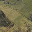
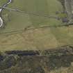
On-line Digital Images |
DP 024768 |
RCAHMS Aerial Photography Digital |
Oblique aerial view centred on the remains of the township and field-system with the farmhouse and farmsteading adjacent, taken from the NNE. |
3/4/2007 |
Item Level |
|
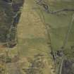 |
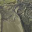
On-line Digital Images |
DP 024769 |
RCAHMS Aerial Photography Digital |
Oblique aerial view centred on the remains of the township and field-system with the road bridges, farmhouse and farmsteading adjacent, taken from the NW. |
3/4/2007 |
Item Level |
|
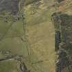 |
On-line Digital Images |
DP 024770 |
RCAHMS Aerial Photography Digital |
Oblique aerial view centred on the remains of the township and field-system with the farmhouse and farmsteading adjacent, taken from the SSE. |
3/4/2007 |
Item Level |
|
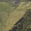 |
On-line Digital Images |
DP 024771 |
RCAHMS Aerial Photography Digital |
Oblique aerial view centred on the remains of the township and field-system with the farmhouse and farmsteading adjacent, taken from the SE. |
3/4/2007 |
Item Level |
|
 |
On-line Digital Images |
DP 024772 |
RCAHMS Aerial Photography Digital |
Oblique aerial view centred on the remains of the township and field-system with the road bridges, farmhouse and farmsteading adjacent, taken from the ENE. |
3/4/2007 |
Item Level |
|
 |
On-line Digital Images |
DP 024775 |
RCAHMS Aerial Photography Digital |
Oblique aerial view centred on the remains of the fish trap with the farmhouse and farmsteading adjacent, taken from the NNW. |
3/4/2007 |
Item Level |
|
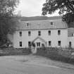 |
On-line Digital Images |
SC 1957685 |
Scottish Development Department |
Inverlael Farm, Lochbroom parish, Ross and Cromarty, Highland |
13/7/1981 |
Item Level |
|
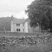 |
On-line Digital Images |
SC 1957686 |
Scottish Development Department |
Inverlael Farm (rear), Lochbroom parish, Ross and Cromarty, Highland |
13/7/1981 |
Item Level |
|
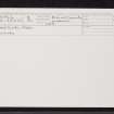 |
On-line Digital Images |
SC 2361164 |
Records of the Ordnance Survey, Southampton, Hampshire, England |
Inverlael Farm, NH18NE 4, Ordnance Survey index card, Recto |
1958 |
Item Level |
|
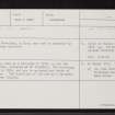 |
On-line Digital Images |
SC 2361165 |
Records of the Ordnance Survey, Southampton, Hampshire, England |
Inverlael Farm, NH18NE 4, Ordnance Survey index card, page number 1, Recto |
1958 |
Item Level |
|


