
Wigtown Airfield, Domestic Site


Air Raid Shelter(S) (Second World War), Military Camp (Second World War)
Site Name Wigtown Airfield, Domestic Site
Classification Air Raid Shelter(S) (Second World War), Military Camp (Second World War)
Alternative Name(s) Baldoon Airfield; Baldoon Hill
Canmore ID 120942
Site Number NX45SW 41.01
NGR NX 4200 5310
NGR Description Centred NX 4200 5310
Datum OSGB36 - NGR
Permalink http://canmore.org.uk/site/120942


- Council Dumfries And Galloway
- Parish Kirkinner
- Former Region Dumfries And Galloway
- Former District Wigtown
- Former County Wigtownshire
NX45SW 41.1 centred 4200 5310
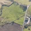
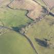
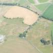
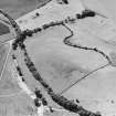
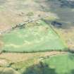
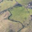
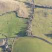
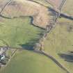
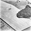
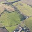
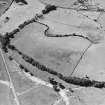
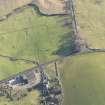
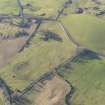
A large accommodation camp for personnel serving at the adjacent Wigtown Airfield is situated between the A714 road and the W side of Baldoon Hill. The camp occupies an area of about 20.26 hectares.
Little sirvives of the camp apart from a few huts and hut bases along with traces of the tracks between the buildings.
The camp is visible on vertical air photographs (106G/Scot/UK 42, 4209-4210, flown 4 may 1946), which show that there were at least 140 buildings and huts with 25 air-raid shelters postioned around the perimeter of the area.
Information from RCAHMS (DE), April 2006
Note (21 May 2021)
The Pillbox Study Group have identified thirty two Stanton type Air Raid shelters around the perimeter of the domestic camp at Wigtown Airfield. The locations of the Air Raid Shelters are
NX 4207 5336
NX 4210 5336
NX 4214 5332
NX 4213 5327
NX 4215 5324
NX 4218 5318
NX 4218 5317
NX 4219 5315
NX 4217 5312
NX 4213 5312
NX 4210 5308
NX 4209 5306
NX 4209 5304
NX 4210 5304
NX 4210 5297
NX 4206 5299
NX 4205 5301
NX 4203 5301
NX 4195 5301
NX 4193 5304
NX 4189 5307
NX 4189 5314
NX 4191 5319
NX 4193 5323
NX 4195 5326
NX 4197 5330
NX 4188 5295
NX 4185 5291
NX 4205 5280
NX 4210 5281
NX 4216 5282
NX 4227 5293
Information from Pillbox Study Group to HES 21 May 2021

