
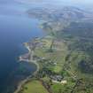
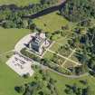
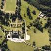
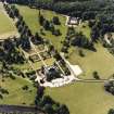
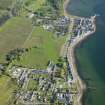
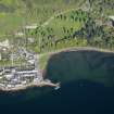
Inveraray Castle, Garden


Garden (Period Unassigned)
Site Name Inveraray Castle, Garden
Classification Garden (Period Unassigned)
Alternative Name(s) Inveraray Castle Policies
Canmore ID 120654
Site Number NN00NE 15.02
NGR NN 0955 0915
Datum OSGB36 - NGR
Permalink http://canmore.org.uk/site/120654


- Council Argyll And Bute
- Parish Inveraray
- Former Region Strathclyde
- Former District Argyll And Bute
- Former County Argyll
NN00NE 15.02 094 090
NN 278 148 to NN 116 118 A desk-based assessment and reconnaissance field survey were carried out in March and April 2002 along the route of a proposed 132kV electricity power line between the N end of Loch Sloy (NN 278 148) and the existing sub-station at Dubh Loch, Glen Shira (NN 116 118).
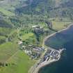
Most of the ten sites located by the study have been previously recorded and include the designed landscape associated with Inveraray Castle, including the Garadh Crom enclosure boundary and the deserted settlement at Blairowin (NN11SW 6); and other medieval or later settlements at Brannie Burn, An Caorachan and Inver, Glen Fyne. The only new sites discovered were two parallel field banks at NN 121 118 and NN 122 119, running about 50m apart below the Garadh Crom and probably associated with Blairowin.
Archive to be deposited in the NMRS.
Sponsor: ASH Consulting Group.
K Cameron 2002
Inveraray Castle Garden.
Architect: John Adam, 1758.

