
Edinburgh, Pleasance, Flodden Wall


Wall (16th Century)
Site Name Edinburgh, Pleasance, Flodden Wall
Classification Wall (16th Century)
Alternative Name(s) Drummond Street; Edinburgh Town Wall
Canmore ID 119866
Site Number NT27SE 1658
NGR NT 26238 73483
Datum OSGB36 - NGR
Permalink http://canmore.org.uk/site/119866


- Council Edinburgh, City Of
- Parish Edinburgh (Edinburgh, City Of)
- Former Region Lothian
- Former District City Of Edinburgh
- Former County Midlothian
NT27SE 1658 26238 73483
NT27SE 1571 NT 26199 73414 Flodden Wall (Drummond Street)
NT27SE 3931 NT 2589 7327 Lothian Street
NT27SE 5197 NT 2527 7335 to NT 2528 7334 Johnston Terrace to Grassmarket
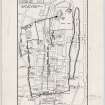
Scheduled (with NT27SE 1571) as 'Edinburgh Town Wall, Flodden Wall, Drummond Street to Pleasance... a stretch of the Flodden Wall, one of Edinburgh's late medieval town walls, dating to circa 1513. The stretch runs ENE along Drummond Street, from NT2613 7338 to NT 2625 7344, where it turns a right-angled corner and then runs NNW along the Pleasance to NT 2621 7352'.
Information from Historic Scotland, scheduling documment dated 4 February 2003.
Publication Account (1951)
59. The Flodden Wall.
The circumstances under which the defence known as the Flodden Wall came to be built have been stated in the Introduction ([RCAHMS 1951] p. lxiv) and the course of the Wall itself has likewise been described. This article is accordingly restricted to an account of the surviving fragments of the work.
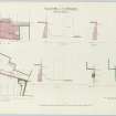
On the E. side of the Vennel, S. of Brown's Place, may be seen the shell of the only surviving tower of the Flodden Wall. Roughly square on plan, its rubble walls, which are about 4 ft. thick, now stand about 20 ft. high from the ground at the S.W. corner to the modern embattled top. It measures 23 ft.9 in. along the S. and 24 ft. 6 in. along the W. side, the N. side, which is incomplete, having a present length of 7 ft. 3 in. In each of the outer walls were two gunloops, slots 21 in. wide and 3 ft. 5 in. long with trefoiled loops at top and bottom; both the W. loops are intact, while only one survives to N. and to S. In 1876, as an inscription testifies, the Town Council inserted a window beside the latter.
Between the Vennel and Bristo nothing remains of the Wall, but its course is marked by a gap, the lower part of which has been filled in, separating Nos. 5 and 7 Forrest Road. Then in the cul-de-sac called Bristo Port the base of the Wall runs for a distance of some 40 ft. as the outer wall of a tenement, and has been pierced for windows. Beyond this tenement a slighter boundary-wall continues for several yards to the E. This, too, may have been part of the Wall, which appears again in the Exhibition Hall at the back of the Royal Scottish Museum in Chambers Street. Here two fragments have been preserved in situ as permanent exhibits, each measuring 3 ft. 6 in. thick and standing to a total height of 24 ft., the lower 9 ft. 6 in. being below floor level. A third fragment, very considerably rebuilt, remains in the yard at the back of the Museum and E. of Brighton Street. In Drummond Street again the base of the wall is seen running shoulder-high inside the present boundary of the Engineering Department of Edinburgh University; on the W. of the entrance gate there is a stretch of some 30 yards, and it continues, after an interval on the E. side of the gate, to the corner of Drummond Street and the Pleasance as the lower part of the present boundary-wall. At this corner there was a circular tower. Although the tower itself has been demolished the wall that closed in the gorge survives; but as this wall contains a wide built-up archway of a type more common in the 17th century than earlier it may have been renewed. In the infilling of the archway there has been formed a doorway giving access to a little cell inside. From this corner the lower part of the Wall survives in places behind the tenements on the W. side of the Pleasance; and the stretch of walling that is exposed to the street between Nos. 1 and 9, where more modern masonry is seen surmounting older work above a height of about 25 ft., may be the only substantial fragment still remaining of the 16th-century defences.
RCAHMS 1951

