
Carn Na Sean-chreag


Fort (Period Unassigned), Galleried Dun (Iron Age)
Site Name Carn Na Sean-chreag
Classification Fort (Period Unassigned), Galleried Dun (Iron Age)
Canmore ID 11904
Site Number NG83SW 2
NGR NG 8188 3147
Datum OSGB36 - NGR
Permalink http://canmore.org.uk/site/11904


- Council Highland
- Parish Lochalsh
- Former Region Highland
- Former District Skye And Lochalsh
- Former County Ross And Cromarty
NG83SW 2 8188 3147.
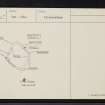
At NG 8188 3147, above a low crag known as Carn na Sean-chreige, overlooking Loch Achaidh na h-Inich, there are the much reduced remains of a galleried fort.
It is sub-rectangular on plan measuring c. 30.0m NW-SE by 28.0m transversely within a wall robbed to its lowest courses. The wall is generally 3.9m in thickness, and faced externally with large blocks. Within the wall are traces of a 'stabilising' wall, surviving at one point in the NE to three courses and 0.9m in height. Near the NW corner is part of a gallery, c. 1.0m in height and 0.9m in width, with one stone roof lintel still in situ. Traces of another gallery are visible in the NE side. The SW side has almost completely slipped over the crag, and is marked by a scatter of loose stones only. The entrance is placed centrally in the NE side; it is 1.4m in width and one door check survives. The interior is featureless and has been recently afforested. (cf. Dun Liath, Skye: NG 37 SE2).
Surveyed at 1/10,00.
Visited by OS (A A) 6 April 1970.
Both door checks of the entrance are now visible 1.3m along the passage from the outer wall face. The passage is 1.3m wide, expanding to 1.6m beyond the door checks.
Revised at 1/10,000.
Visited by OS (A A) 21 May 1974.
Publication Account (2007)
NG83 1 CARN NA SEAN-CHREIGE
NG/81988 3147
This galleried dun in Lochalsh, Ross and Cromarty, may be a gallery-walled fort of an architecturally related but more primitive kind, like Dun Liath or Dun Kearstach on Skye (NG37 2 and NG51 2). It stands on a low crag with one face of its diamond-shaped plan along the precipit-ous edge. It measures 30.0m north-west/south-east by 28.0m transversely and the wall is about 3.9m thick. There are traces of a “stabilizing” wallface in the core in places but definite signs of a gallery near the north-west comer (near the cliff edge), with one lintel still in position. The entrance is in the middle of the north-east side, opposite the cliff, and both door-checks can be seen, 1.3m in from the outer face. The passage is 1.3m wide in front of the door-frame, and 1.6m behind it.
Source: 1. NMRS site no. NG 83 SW 2 (with plan).
E W MacKie 2007
Measured Survey (8 February 2014)
NG 8188 3147 A detailed topographic survey of the surviving remains of a late prehistoric/early historic possible galleried fort at Sean Craig was carried out on 8 February 2014. The survey allowed the creation of a digital terrain model, contour based plans and oblique terrain models of the site within its landscape setting, which will be utilised to inform future
conservation and management of the monument by Forestry Commission Scotland. It was one of a group of six such surveys carried out on Forestry Commission Scotland sites in February 2014. The other sites were at Castle Greg, Craig Phadrig, Round Dounan, Dun Deardail and Torr Dhuin.
Archive: RCAHMS
Funder: Forestry Commission Scotland
Louise Baker and Enda O’Flaherty – Rubicon Heritage Services Ltd
(Source: DES)
OASIS ID: rubiconh1-189897
Archaeological Evaluation (20 October 2014 - 24 October 2014)
NG 81889 31472 An evaluation was undertaken, 20–14 October 2014, at Sean Craig Fort (SAM 5532). Two trenches were excavated over the entrance and over a section of intramural gallery. The work aimed to clear and record the entrance of the fort ahead of the upgrading of the footpath to the site and through the entrance, in order to establish the nature and
extent of any surviving deposits and to learn more about the form, function and date of the site.
The trench across the entrance, in the NE quadrant of the fort, recorded two surviving wall faces built on top of the bedrock outcrop and subsoil. There were no archaeological finds recovered from the trench, although a level, intermediate deposit of small stone clasts between mixed rubble layers appeared to be an intentional fill within the entrance. Within the entrance passage, the walling protruded on the interior to form door checks and fragmentary remains of small slabs at the base may have formed a floor surface. Angled slabs and protruding stonework built into the SE entrance wall indicated that the wall may have been rebuilt, possibly closing off a guard cell entrance on the SE side.
The second trench, excavated across a section of intramural gallery in the NW quadrant, recorded two surviving courses of outer wall face consisting of large upright slabs. The intramural gallery space, measuring 0.7m wide and up to 1m high, consisted of well built rubble wall faces on top of the natural subsoil. There were no archaeological horizons encountered and the only artefact recovered was a fragment of antler from within the rubble fill.
Further survey of the fort, conducted to enhance the existing measured survey, identified mostly continuous intramural gallery spaces to both sides of the entrance that terminated at the rock face along the SW edge of the terrace. A possible cell on the inside of the fort may be the remains of an attached structure and entrance passage into the gallery on the NW side of the site.
Report: Highland HER, OASIS and RCAHMS (intended)
Funder: Forestry Commission Scotland
Mary Peteranna, Steven Birch, Cathy MacIvor and Sam Williamson – Ross and Cromarty Archaeological Services and West Coast Archaeological Services
(Source: DES)
OASIS ID: rosscrom1-204823
Note (20 January 2015 - 30 May 2016)
This small fortification stands at the top of a crag facing out SW over Loch Achaid na h-Inich. Sub-rectangular on plan, it measures about 30m from NW to SE by 28m transversely (0.08ha) within a robbed wall about 3.9m in thickness. The outer face of large blocks survives around most of the circuit, and is only missing on the SE and where the wall peters out along the cliff-edge on the SW; the inner face can be seen around the E angle and on the NW. The entrance is in the middle of the NE side, narrowing from 1.3m wide to 1.6m at the door checks set 1.3m back from the outer end of the passage. An internal face within the thickness of the wall along the NE and NW sides was interpreted by the OS as an internal stabilising structure, but there are also traces of the galleries in the wall near the W and E corners, the former 0.9m wide and still retaining one of its lintels in place. The interior, which has been forestry ploughed, is featureless.
Information from An Atlas of Hillforts of Great Britain and Ireland – 30 May 2016. Atlas of Hillforts SC2726

