
Kinghornie


Enclosure (Prehistoric)(Possible), Pit(S) (Prehistoric)(Possible), Roundhouse(S) (Prehistoric), Souterrain (Prehistoric)(Possible)
Site Name Kinghornie
Classification Enclosure (Prehistoric)(Possible), Pit(S) (Prehistoric)(Possible), Roundhouse(S) (Prehistoric), Souterrain (Prehistoric)(Possible)
Canmore ID 118771
Site Number NO87SW 64
NGR NO 8369 7263
NGR Description Discovery area centred at NO 8369 7263
Datum OSGB36 - NGR
Permalink http://canmore.org.uk/site/118771


- Council Aberdeenshire
- Parish Kinneff
- Former Region Grampian
- Former District Kincardine And Deeside
- Former County Kincardineshire
NO87SW 64 8369 7263
See also NO87SW 35.
Identified by Aberdeenshire Archaeological Service as solid circular cropmark, post-pits and possible enclosure.
(AAS/96/07/G20/1-4) NMRS, MS/712/17.
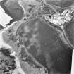
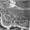
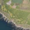
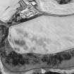
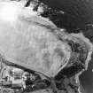
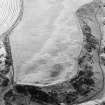
Oblique aerial photography (RCAHMSAP 2001) has recorded the cropmarks of round-houses, one with a possible souterrain, a possible enclosure and pits on a gently sloping terrace adjacent to Kinghornie farmsteading (NO87SW 57). The cropmarks consist of three circular maculae, the two to the E measuring about 10m in diameter and the one to the W slightly larger. This larger example has a curved cropmark emanating from its N arc that may indicate the presence of a souterrain, or perhaps a severely truncated round-house. A possible curvilinear enclosure is also visible to the W of the larger round-house and several pits are scattered around the central, and best-defined, round-house. About 25m to the W are the cropmarks of possible grave pits (NO87SW 35).
Information from RCAHMS (SMDG) 18 December 2002
Note (1982)
Kinghornie NO 836 726 NO87SW
Cropmarks ESE of Kinghornie farmhouse reveal what may be the site of at least one circular timber house.
RCAHMS 1982

