|
Photographs and Off-line Digital Images |
ED 3385 |
H D Wyllie |
Leith Walk
View from Regent Bridge of Calton Road and Leith Street |
c. 1930 |
Item Level |
|
|
Photographs and Off-line Digital Images |
ED 3257 |
H D Wyllie |
View of elevation of White Horse Close to Calton Road (North Back of Canongate). |
c. 1930 |
Item Level |
|
|
Photographs and Off-line Digital Images |
ED 9600 |
|
Elevation of White Horse Close to Calton Road (North Back of Canongate) |
1855 |
Item Level |
|
|
Prints and Drawings |
EDD 939/1 |
Records of Dunn and Findlay, architects, Edinburgh, Scotland |
Edinburgh, 93-109 Abbeyhill, Abbeyhill Chemical Works.
Block plan showing site bounded by Holyrood Terrace, Abbeyhill, Calton Road, Calton Burial Ground and railway.'
Titled: 'Abbeyhill Chemical Works - 93 & 109 Abbeyhill.'
Insc: 'Messrs J. F. Macfarlan & Coy.' |
2/1934 |
Item Level |
|
|
Prints and Drawings |
EDD 939/2 |
Records of Dunn and Findlay, architects, Edinburgh, Scotland |
Edinburgh, 93-109 Abbeyhill, Abbeyhill Chemical Works..
Plans of ground floor, first floor and new roof, elevation to Calton Road, Sections A-A and B-B.'
Titled: 'Premises-Nos 67-69-71 & 73 Calton Road (North Back of Canongate) belonging to Messrs J.F.Macfarlan & Co.'
Insc: 'Proposed partial demolition' 'James B. Dunn & Partners, 14 Frederick Street, Edinburgh.' |
11/1932 |
Item Level |
|
|
Photographs and Off-line Digital Images |
C 39113 |
Survey of a Private Collection: Mr Bews, Survey No.210 |
Calton Road
View from north.
NMRS Survey of Private Collections. |
1950 |
Item Level |
|
|
Print Room |
RAB 220/511 |
General Collection |
Page 511, Engraving of road arch and neighbouring buildings |
1838 |
Item Level |
|
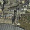 |
On-line Digital Images |
DP 026266 |
RCAHMS Aerial Photography Digital |
Oblique aerial view centred on the road bridge with the Old Calton burial-ground adjacent, taken from the SSE. |
21/3/2007 |
Item Level |
|
 |
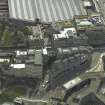
On-line Digital Images |
DP 026267 |
RCAHMS Aerial Photography Digital |
Oblique aerial view centred on the road bridge with the burial-ground adjacent, taken from the E. |
21/3/2007 |
Item Level |
|
 |
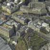
On-line Digital Images |
DP 026270 |
RCAHMS Aerial Photography Digital |
Oblique aerial view centred on the road bridge, burial-ground and theatre, taken from the NNW. |
21/3/2007 |
Item Level |
|
|
Print Room |
RAB 362/OP184 |
General Collection |
Engraving of St Ninian's Row, taken down 1844. Small street sign "Low Calton". |
1891 |
Item Level |
|
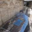 |
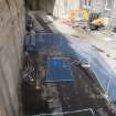
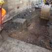
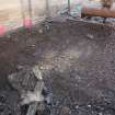
On-line Digital Images |
DP 183793 |
Records from Headland Archaeology Ltd, archaeologists, Edinburgh, Scotland |
Pre-excavation shot from the gantry |
7/2013 |
Item Level |
|
 |
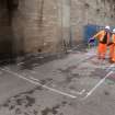
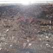
On-line Digital Images |
DP 183794 |
Records from Headland Archaeology Ltd, archaeologists, Edinburgh, Scotland |
Pre-excavation shot from the gantry |
7/2013 |
Item Level |
|
 |
On-line Digital Images |
DP 183795 |
Records from Headland Archaeology Ltd, archaeologists, Edinburgh, Scotland |
Pre-excavation shot from the gantry |
7/2013 |
Item Level |
|
 |
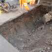
On-line Digital Images |
DP 183796 |
Records from Headland Archaeology Ltd, archaeologists, Edinburgh, Scotland |
Pre-excavation shot from ground level |
7/2013 |
Item Level |
|
 |
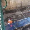
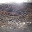
On-line Digital Images |
DP 183797 |
Records from Headland Archaeology Ltd, archaeologists, Edinburgh, Scotland |
Working shot of bitumen removed |
7/2013 |
Item Level |
|
 |
On-line Digital Images |
DP 183798 |
Records from Headland Archaeology Ltd, archaeologists, Edinburgh, Scotland |
Mid-excavation shot showing upper made ground |
7/2013 |
Item Level |
|
 |
On-line Digital Images |
DP 183799 |
Records from Headland Archaeology Ltd, archaeologists, Edinburgh, Scotland |
Mid-excavation shot showing upper made ground. |
7/2013 |
Item Level |
|
 |
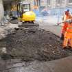
On-line Digital Images |
DP 183800 |
Records from Headland Archaeology Ltd, archaeologists, Edinburgh, Scotland |
General work shot |
7/2013 |
Item Level |
|
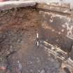 |
On-line Digital Images |
DP 183801 |
Records from Headland Archaeology Ltd, archaeologists, Edinburgh, Scotland |
East extent mid-excavation showing W facing section |
7/2013 |
Item Level |
|
 |
On-line Digital Images |
DP 183802 |
Records from Headland Archaeology Ltd, archaeologists, Edinburgh, Scotland |
Working shot |
7/2013 |
Item Level |
|
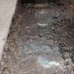 |
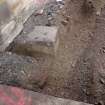
On-line Digital Images |
DP 183803 |
Records from Headland Archaeology Ltd, archaeologists, Edinburgh, Scotland |
East extent showing original floor of station wall |
7/2013 |
Item Level |
|
 |
On-line Digital Images |
DP 183804 |
Records from Headland Archaeology Ltd, archaeologists, Edinburgh, Scotland |
East extent showing horizontal stratification change |
7/2013 |
Item Level |
|
 |
On-line Digital Images |
DP 183805 |
Records from Headland Archaeology Ltd, archaeologists, Edinburgh, Scotland |
East extent showing bitumen surface in foreground |
7/2013 |
Item Level |
|


