
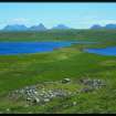
Loch Vatachan


Field System (Prehistoric), Hut Circle(S) (Prehistoric)
Site Name Loch Vatachan
Classification Field System (Prehistoric), Hut Circle(S) (Prehistoric)
Canmore ID 116407
Site Number NC01SW 34
NGR NC 0125 1150
Datum OSGB36 - NGR
Permalink http://canmore.org.uk/site/116407


- Council Highland
- Parish Lochbroom
- Former Region Highland
- Former District Ross And Cromarty
- Former County Ross And Cromarty
Field Visit (10 August 1994)
NC01SW 34 0125 1150
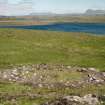
On the heather-and-grass covered E-facing slopes overlooking the N end of Loch Vatachan there are four hut-circles standing amidst the remains of a field-system consisting of scatters of small cairns and stretches of bank. The most southerly hut-circle (ACHIL94 454; NC 0129 1138) stands on a gentle ESE-facing slope. It measures 8m in diameter within a wall 1m thick and 0.3m high. Occasional inner and outer facing-stones survive and the wall thickens slightly at the entrance, which is on the SE.
The other three hut-circles are located on steeper slopes, and they are all levelled into the hillside along their rear edge and built up at the front; all three are also oval in plan, with the longer axis running parallel to the contour.
The first of these huts is situated about 120m NNW of the first hut-circle, at NC 0125 1150 (ACHIL94 455). It measures 6.5m N-S by 5.9m transversely within a stony bank 0.3m high and spread to a thickness of 1m. The entrance is on the N.
About 90m to the NW there is a hut-circle measuring 9.4m N-S by 7.9m E-W within a stony bank 0.5m high which has spread to 1.3m in thickness (ACHIL94 456; NC 0119 1157).
The final hut is 240m farther N at NC 0121 1181 (ACHIL94 457). It measures 7m NNW-SSE by 6.2m transversely within a massive wall in which edge-set inner and outer facing-stones survive, giving a thickness of 1.6m. The entrance may have been on the SE.
Around these hut-circles, in an area measuring about 500m N-S by 150m E-W there are a number of stony banks and lynchets which appear to have formed a series of subrectangular fields. Within these there are scatters of small cairns, about 35 in all, concentrated particularly at the S end of the area, between hut-circles ACHIL94 454 and ACHIL94 455.
(ACHIL94 454-7)
Visited by RCAHMS (SDB) 10 August 1994

