
Scalpay, Teampull Fraing


Burial Ground (Medieval), Chapel (Medieval)
Site Name Scalpay, Teampull Fraing
Classification Burial Ground (Medieval), Chapel (Medieval)
Alternative Name(s) Francaig
Canmore ID 11570
Site Number NG62NW 1
NGR NG 6285 2816
Datum OSGB36 - NGR
Permalink http://canmore.org.uk/site/11570


- Council Highland
- Parish Strath
- Former Region Highland
- Former District Skye And Lochalsh
- Former County Inverness-shire
Scalpay, Skye & Lochalsh, cross-slab
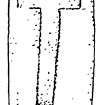
Measurements: H 1.12m, W 0.21m, D 0.10m
Stone type: red grit
Place of discovery: NG 6285 2816
Present location: in situ near Teampull Fraing.
Evidence for discovery: noted by RCAHMS during fieldwork in 1914.
Present condition: very weathered.
Description
On the east face of this tall slab is an incised outline cross.
Date range: seventh or eighth century.
Primary references: RCAHMS 1928, no 646; Fisher 2001, 102.
Compiled by A Ritchie 2016
Field Visit (11 May 1914)
Teampull Fraing, Island of Scalpay.
Near the south-east corner of the island of Scalpay, on a grassy knowe on the west side of a small burn, sheltered by sharply rising hills to the north-west, some 300 yards south-west of Scalpay House and about 150 yards from the shore, in a burying ground which is still occasionally used, are the fragmentary remains of Teampull Fraing, the area which includes the church and burying ground being known locally as Francaig. The church has been built of stone and shell lime, but is now an utter ruin. It is oblong on plan, and orientated a little south of east and west of north. The best preserved part of the Teampull is at the eastern end, where the gable reaches a height of 4 feet 6 inches, otherwise the walls have a height only of 2 to 3 feet above the outer level. The building measures about 21 feet in length and 12 feet in breadth internally and the wall is about 3 feet thick. Apparently the door has been near the western end of the southern wall. In the mortar, which contains many oyster, mussel, limpet, whelk and other shells, fragments of charred wood used in burning the lime were noted at one place.
RCAHMS 1928, visited 11 May 1914.
OS map: Skye xl.
Desk Based Assessment (1960)
NG62NW 1 6285 2816.
(NG 6285 2816.) Teampull Fraing (NR) (Ruins of)
OS 6"map, Inverness-shire, 2nd ed., (1903)
In a burying ground, which is still occasionally used, are the fragmentary remains of Teampull Fraing, or Teampull Frangaia (the Temple of St. Francis) (NSA 1845), the area which includes the church and burying ground being known locally as Francaig. The church has been built of stone and shell lime, but is now an utter ruin. It is oblong on plan, and orientated a little S of E and W of N. The best preserved part is at the E end where the gable reaches a height of 4ft 6ins, otherwise the walls have a height of only 2-3ft above the outer level. The building measures about 21ft in length and 12ft in breadth internally, the wall being about 3ft thick. Apparently the door has been near the W end of the S wall.
A few yards W of the church stands a narrow undressed slab of red grit, 3ft 9ins above ground, 8 1/2ins in breadth and varying from 3-5ins in thickness, on the E face of which is a rude incised Latin cross (RCAHMS 1928).
Information from OS Recorder.
(New Statistical Account (NSA) 1845; RCAHMS 1928).
Field Visit (26 June 1961)
This chapel is as described by RCAHMS, also the incised cross. The graveyard is still in use.
Visited by OS (C F W) 26 June 1961.

