
Big Burn


Building (Period Unassigned), Rig And Furrow (Medieval)
Site Name Big Burn
Classification Building (Period Unassigned), Rig And Furrow (Medieval)
Canmore ID 115097
Site Number NH63NE 67
NGR NH 6603 3881
Datum OSGB36 - NGR
Permalink http://canmore.org.uk/site/115097

- Council Highland
- Parish Inverness And Bona
- Former Region Highland
- Former District Inverness
- Former County Inverness-shire
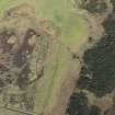
Aerial photographs (RCAHMSAP 1994 and RAF 541 A435, frame no.3073) show a long building, or possibly two shorter buildings on the same alignment, in a patch of rough grassland to the SE of the Big Burn. The flatter ground around the building bears faint traces of rig.
Information from RCAHMS (DCC) 31 January 1997
Ground Survey (September 2010)
NH 657 383 (centred on) A desktop and walkover survey
were undertaken for an area of proposed forestry in
September 2010. Work revealed the following previously
unrecorded sites:
NH 6551 3841 Buildings
NH 6603 3881 Farmstead (NH63NE 67 incorrect NGR)
NH 65817 38685 Building and kiln
NH 66143 38999 and NH 66135 38995 Clearance cairns
NH 66042 38963 Clearance cairn
NH 65963 38679 Building
NH 65316 37718 to NH 65590 37623 Field wall
NH 65633 38211 Kiln
NH 65747 38034 Hut circle
Archive and report: RCAHMS
Funder: UPM Tilhill

