
Skye, Kilbride


Cairn (Prehistoric)
Site Name Skye, Kilbride
Classification Cairn (Prehistoric)
Canmore ID 11448
Site Number NG52SE 1
NGR NG 58689 20306
Datum OSGB36 - NGR
Permalink http://canmore.org.uk/site/11448


- Council Highland
- Parish Strath
- Former Region Highland
- Former District Skye And Lochalsh
- Former County Inverness-shire
Field Visit (15 May 1914)
Teampull Choan, Boreraig.
The site of this church is on a grassy flat above the sea-shore about 400 yards east-north-east of Dun Boreraig [NG61NW 2]. No traces of a building are now discernible.
RCAHMS 1928, visited 15 May 1914.
OS map: Skye li. ("Chaoin")
Field Visit (17 April 1961)
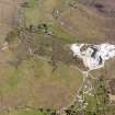
NG52SE 1 5868 2030.
(NG 5868 2030) Stone Circle (NR) (Site of)
OS 6"map, Inverness-shire, 2nd ed., (1903).
At the site of this supposed stone circle there is a low mound of stones, for the most part turf-covered, measuring 17.0m in diameter and 0.5m in height. It is situated on the edge of boggy ground, which was probably originally a small loch, and has the appearance of a robbed cairn.
Visited by OS (A C) 17 April 1961.

