|
Manuscripts |
MS 228 |
|
Field Notes Basil Megaw & Sir Lindsay Scott c.1950 |
c. 1950 |
Item Level |
|
|
Prints and Drawings |
IND 32/2 |
Records of the Royal Commission on the Ancient and Historical Monuments of Scotland (RCAHMS), Edinbu |
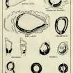
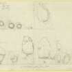
Typological series of galleried structures, drawn to a uniform scale. |
c. 1926 |
Item Level |
|
|
Prints and Drawings |
IND 32/3 |
Records of the Royal Commission on the Ancient and Historical Monuments of Scotland (RCAHMS), Edinbu |
Preparatory drawing; typological series of galleried structures, drawn to a uniform scale. |
c. 1926 |
Item Level |
|
|
Prints and Drawings |
IND 38/1 |
Records of the Royal Commission on the Ancient and Historical Monuments of Scotland (RCAHMS), Edinbu |
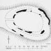
Publication drawing; plan of Dun Kearstach. |
c. 1921 |
Item Level |
|
|
Prints and Drawings |
IND 38/2 |
Records of the Royal Commission on the Ancient and Historical Monuments of Scotland (RCAHMS), Edinbu |
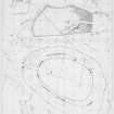
Sketch surveys of Dun Hallin and Dun Kearstach. |
c. 1921 |
Item Level |
|
 |
On-line Digital Images |
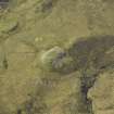
DP 032003 |
RCAHMS Aerial Photography Digital |
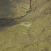
Oblique aerial view centred on the remains of the dun, taken from the E. |
4/5/2007 |
Item Level |
|
 |
On-line Digital Images |
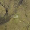
DP 032004 |
RCAHMS Aerial Photography Digital |
Oblique aerial view centred on the remains of the dun, taken from the NE. |
4/5/2007 |
Item Level |
|
 |
On-line Digital Images |
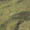
DP 032005 |
RCAHMS Aerial Photography Digital |
Oblique aerial view centred on the remains of the dun, taken from the NW. |
4/5/2007 |
Item Level |
|
 |
On-line Digital Images |
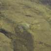
DP 032006 |
RCAHMS Aerial Photography Digital |
Oblique aerial view centred on the remains of the dun, taken from the W. |
4/5/2007 |
Item Level |
|
 |
On-line Digital Images |
DP 032007 |
RCAHMS Aerial Photography Digital |
Oblique aerial view centred on the remains of the dun, taken from the SW. |
4/5/2007 |
Item Level |
|
|
Manuscripts |
MS 36/68 |
Records of the Royal Commission on the Ancient and Historical Monuments of Scotland (RCAHMS), Edinbu |
Field notebook of C S T Calder (RCAHMS). Titled 'Skye and Lewis'. |
27/5/1921 |
Item Level |
|
|
Manuscripts |
MS 7401/31 |
Angus Graham |
Some Observations on the Brochs |
1949 |
Item Level |
|
 |
On-line Digital Images |
DP 208040 |
Records of the Royal Commission on the Ancient and Historical Monuments of Scotland (RCAHMS), Edinbu |
Publication drawing; plan of Dun Kearstach. |
c. 1921 |
Item Level |
|
 |
On-line Digital Images |
DP 208041 |
Records of the Royal Commission on the Ancient and Historical Monuments of Scotland (RCAHMS), Edinbu |
Sketch surveys of Dun Hallin and Dun Kearstach. |
c. 1921 |
Item Level |
|
 |
On-line Digital Images |
DP 209728 |
Records of the Royal Commission on the Ancient and Historical Monuments of Scotland (RCAHMS), Edinbu |
Typological series of galleried structures, drawn to a uniform scale. |
c. 1926 |
Item Level |
|
 |
On-line Digital Images |
DP 209729 |
Records of the Royal Commission on the Ancient and Historical Monuments of Scotland (RCAHMS), Edinbu |
Preparatory drawing; typological series of galleried structures, drawn to a uniform scale. |
c. 1926 |
Item Level |
|
 |
On-line Digital Images |
SC 2359694 |
Records of the Ordnance Survey, Southampton, Hampshire, England |
Skye, Dun Kearstach, NG51NE 3, Ordnance Survey index card, page number 1, Recto |
1958 |
Item Level |
|
 |
On-line Digital Images |
SC 2359695 |
Records of the Ordnance Survey, Southampton, Hampshire, England |
Skye, Dun Kearstach, NG51NE 3, Ordnance Survey index card, page number 2, Verso |
1958 |
Item Level |
|
 |
On-line Digital Images |
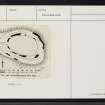
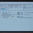
SC 2359696 |
Records of the Ordnance Survey, Southampton, Hampshire, England |
Skye, Dun Kearstach, NG51NE 3, Ordnance Survey index card, Recto |
1958 |
Item Level |
|
 |
On-line Digital Images |
SC 2359697 |
Records of the Ordnance Survey, Southampton, Hampshire, England |
Skye, Dun Kearstach, NG51NE 3, Ordnance Survey index card, Recto |
1958 |
Item Level |
|
 |
On-line Digital Images |
SC 2359698 |
Records of the Ordnance Survey, Southampton, Hampshire, England |
Skye, Dun Kearstach, NG51NE 3, Ordnance Survey index card, Recto |
1958 |
Item Level |
|
|
All Other |
551 166/1/1 |
Records of the Ordnance Survey, Southampton, Hampshire, England |
Archaeological site card index ('495' cards) |
1947 |
Sub-Group Level |
|


