
Skye, Suisnish


Township (Period Unassigned)
Site Name Skye, Suisnish
Classification Township (Period Unassigned)
Canmore ID 11423
Site Number NG51NE 12
NGR NG 589 160
Datum OSGB36 - NGR
Permalink http://canmore.org.uk/site/11423


- Council Highland
- Parish Sleat
- Former Region Highland
- Former District Skye And Lochalsh
- Former County Inverness-shire
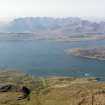
Boreraig and Suisinish. Clearance villages on Loch Eishort's northern shore, rich with evidence of settlement and land use spanning centuries. Boreraig is particularly haunting, surviving almost as it was when cleared in 1852, 'prompted by motives of benevolence, piety, and humanity ... because they were too far from the church' according to Lord Macdonald's factor!
[The geologist Sir Archibald Geikie witnessed the forced evictions from Suisinish: 'As I was returning from my ramble a strange wailing sound reached my ears at intervals on the breeze from the west. On gaining the top of a hill on the south side of the valley, I could see a long and motley procession wending along the road that led from Suisnish. It halted at the point in the road opposite Kilbride, and there the lamentation became long and loud ... Every one was in tears; ... and it seemed as if they could not tear themselves away. When they set off once more, a cry of grief went up to heaven; the long plaintive wail, like a funeral coronach, was resumed; and, after the last of the emigrants had disappeared behind the hill, the sound seemed to re-echo through the whole wide valley of Strath in one prolonged note of desolation'.]
Taken from "Western Seaboard: An Illustrated Architectural Guide", by Mary Miers, 2007. Published by the Rutland Press http://www.rias.org.uk

NG51NE 12 589 160.
(NG 589 160) Suisnish: cleared by Lord MacDonald in 1852, (A Nicolson 1930) partly occupied 1876 (OS 6"map, Isle of Skye, Inverness-shire, 1st ed.)
A Nicolson 1930.
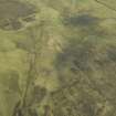
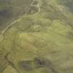
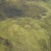
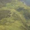
The depopulated township of Suisnish shows two distinct phases of occupation.
The first is represented by a run-rig township of 10 houses and 4 outbuildings situated in a compact group on a shelf by a stream at NG 594 160.
The second phase is represented by a typical improvements township, centred NG 589 160, comprising about twelve crofts, some with outbuildings and yards still extant, each situated within its own large enclosure, and occupying the whole of the Rubha Suisnish headland.
The township is in use as a sheep-run, and deserted except for a shepherd's house.
Visited by OS (C F W) 19 June 1961.
A crofting township, comprising four roofed buildings, one partially roofed building, twenty unroofed of which three are long buildings and twelve enclosures is depicted on the 1st edition of the OS 6-inch map (Inverness-shire, Isle of Skye 1881, sheet li). Three roofed buildings, one partially roofed building and thirty-six unroofed buildings are shown on the current edition of the OS 1:10560 map (1965).
Information from RCAHMS (AKK) 29 November 1996.

