 |
On-line Digital Images |
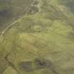
DP 031997 |
RCAHMS Aerial Photography Digital |
Oblique aerial view centred on the remains of the township, taken from the NNW. |
4/5/2007 |
Item Level |
|
 |
On-line Digital Images |
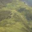
DP 031998 |
RCAHMS Aerial Photography Digital |
Oblique aerial view centred on the remains of the township, taken from the WNW. |
4/5/2007 |
Item Level |
|
 |
On-line Digital Images |
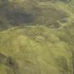
DP 031999 |
RCAHMS Aerial Photography Digital |
Oblique aerial view centred on the remains of the township, taken from the W. |
4/5/2007 |
Item Level |
|
 |
On-line Digital Images |
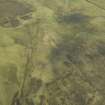
DP 032000 |
RCAHMS Aerial Photography Digital |
Oblique aerial view centred on the remains of the township, taken from the WSW. |
4/5/2007 |
Item Level |
|
 |
On-line Digital Images |
DP 032001 |
RCAHMS Aerial Photography Digital |
Oblique aerial view centred on the remains of the township, taken from the SW. |
4/5/2007 |
Item Level |
|
 |
On-line Digital Images |
DP 032002 |
RCAHMS Aerial Photography Digital |
Oblique aerial view centred on the remains of the township, taken from the SW. |
4/5/2007 |
Item Level |
|
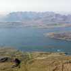 |
On-line Digital Images |
DP 109260 |
RCAHMS Aerial Photography Digital |
General oblique aerial view of the township of Ord, looking across Loch Eishort to the remains of the township of Suisnish and further across Loch Slappin to Kilmarie, Strathaird and Blabheinn, Skye, taken from the ESE. |
30/4/2011 |
Item Level |
|
 |
On-line Digital Images |
SC 2359723 |
Records of the Ordnance Survey, Southampton, Hampshire, England |
Skye, Suisnish, NG51NE 12, Ordnance Survey index card, Recto |
1958 |
Item Level |
|
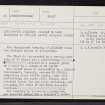 |
On-line Digital Images |
SC 2359724 |
Records of the Ordnance Survey, Southampton, Hampshire, England |
Skye, Suisnish, NG51NE 12, Ordnance Survey index card, page number 1, Recto |
1958 |
Item Level |
|


