 |
On-line Digital Images |
SC 396897 |
RCAHMS Aerial Photography |
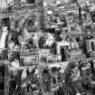
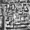
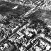
Aerial view of centre of Edinburgh including Market Street on left of photograph, North and South Bridges at top, George IV Bridge to right and Upper Bow at bottom |
1994 |
Item Level |
|
 |
On-line Digital Images |
SC 421929 |
|
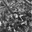
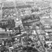
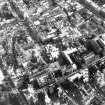
Oblique aerial view of centre of Edinburgh including Lawnmarket at bottom of photograph, Cockburn Street at left, South Bridge at top and National Library of Scotland, George IV Bridge at right |
|
Item Level |
|
 |
On-line Digital Images |
SC 421975 |
|
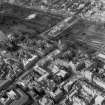
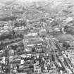
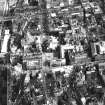
Oblique aerial view of centre of Edinburgh including Princes Street at top of photograph, Waverley Bridge to right, Parliament Square, High Court of Justiciary to bottom and Castlehill to left |
|
Item Level |
|
 |
On-line Digital Images |
SC 555294 |
Papers of Professor John R Hume, economic and industrial historian, Glasgow, Scotland |
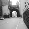
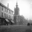
Edinburgh, George IV Bridge
View of bridge as seen from the Cowgate |
1978 |
Item Level |
|
 |
On-line Digital Images |
SC 555295 |
Papers of Professor John R Hume, economic and industrial historian, Glasgow, Scotland |
Edinburgh, George IV Bridge
View of bridge as seen from Cowgate |
1978 |
Item Level |
|
 |
On-line Digital Images |
SC 754535 |
|
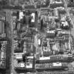
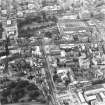
Oblique aerial view of Cowgate and surrounding area, including Chambers Street to left of photograph, George IV Bridge at top, High Street to right and South Bridge at bottom |
1989 |
Item Level |
|
 |
On-line Digital Images |
SC 988446 |
|
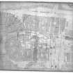
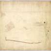
Scanned copy of plan of area showing Victoria Street (Bow Street) as to be altered |
31/8/1829 |
Item Level |
|
 |
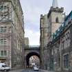
On-line Digital Images |
SC 1098199 |
Collection of photographs by George Chrystal and Francis Maxwell Chrystal, photographers, Edinburgh, |
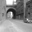
General view of East side of George IV Bridge. |
c. 1900 |
Item Level |
|
 |
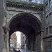
On-line Digital Images |
SC 1122238 |
Collection of photographs by George Chrystal and Francis Maxwell Chrystal, photographers, Edinburgh, |
General view of George IV Bridge looking South. |
c. 1900 |
Item Level |
|
 |
On-line Digital Images |
SC 1135156 |
General Collection |
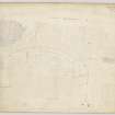
Plan of area South of Castle showing full extent of Western Approaches-Castle terrace, etc plus section of ground below George IV Bridge. Includes pencil notes.
|
28/7/1831 |
Item Level |
|
 |
On-line Digital Images |
DP 093435 |
RCAHMS Field Survey Digital Photography |
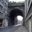
General view from WSW |
18/1/2011 |
Item Level |
|
 |
On-line Digital Images |
DP 093436 |
RCAHMS Field Survey Digital Photography |
View from W |
18/1/2011 |
Item Level |
|
 |
On-line Digital Images |
DP 093437 |
RCAHMS Field Survey Digital Photography |
View from E |
18/1/2011 |
Item Level |
|
 |
On-line Digital Images |
DP 093438 |
RCAHMS Field Survey Digital Photography |
View from E |
18/1/2011 |
Item Level |
|
 |
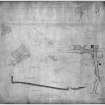
On-line Digital Images |
DP 146815 |
|
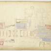
Site plan showing piers of new bridge and part of Victoria Street |
c. 1829 |
Item Level |
|
 |
On-line Digital Images |
DP 146816 |
|
Plan of area showing Victoria Street (Bow Street) as to be altered |
31/8/1829 |
Item Level |
|
 |
On-line Digital Images |
DP 146817 |
General Collection |
Plan of area South of Castle showing full extent of Western Approaches-Castle terrace, etc plus section of ground below George IV Bridge. |
2/7/1862 |
Item Level |
|
 |
On-line Digital Images |
SC 1676870 |
RCAHMS Aerial Photography |
Oblique aerial view of Cowgate and surrounding area, including Chambers Street to left of photograph, George IV Bridge at top, High Street to right and South Bridge at bottom |
1989 |
Item Level |
|
 |
On-line Digital Images |
SC 1678193 |
RCAHMS Aerial Photography |
Aerial view of centre of Edinburgh including Princes Street and the New Town at top of photograph, Waverley Station and St Giles on right, Candlemaker Row at bottom and Castle Esplanade at left |
1993 |
Item Level |
|
 |
On-line Digital Images |
SC 1678194 |
RCAHMS Aerial Photography |
Aerial view of centre of Edinburgh including Princes Street at top of photograph, North Bridge to right, Royal Museum of Scotland and Candlemaker Row at bottom and Tolbooth Church and The Mound to left |
1993 |
Item Level |
|
 |
On-line Digital Images |
SC 1678195 |
RCAHMS Aerial Photography |
Oblique aerial view of centre of Edinburgh including Princes Street and the New Town at top of photograph, Waverley Station to right, Cowgate, Solicitors' Library at bottom and Bank of Scotland on The Mound to left. |
1993 |
Item Level |
|
 |
On-line Digital Images |
SC 1678214 |
RCAHMS Aerial Photography |
Aerial view of centre of Edinburgh including Princes Street at top of photograph, Waverley Bridge to right, Parliament Square, High Court of Justiciary to bottom and Castlehill to left |
1994 |
Item Level |
|
 |
On-line Digital Images |
SC 1678217 |
RCAHMS Aerial Photography |
Aerial view of centre of Edinburgh including Lawnmarket at bottom of photograph, Cockburn Street at left, South Bridge at top and National Library of Scotland, George IV Bridge at right |
1994 |
Item Level |
|
 |
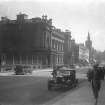
On-line Digital Images |
SC 1678218 |
RCAHMS Aerial Photography |
Aerial view of centre of Edinburgh including Market Street on left of photograph, North and South Bridges at top, George IV Bridge to right and Upper Bow at bottom |
1994 |
Item Level |
|


