|
Photographs and Off-line Digital Images |
A 59431 |
|
Proposed alterations to shop at No 1 Bank Street. Petition for George Strachan. Warrant dated 25 September 1834 |
25/9/1834 |
Item Level |
|
|
Photographs and Off-line Digital Images |
A 59417 |
|
Proposed alterations to shop at No 2 Bank Street-elevation and plan. Petition for John Cameron. Warrant dated 6 September 1832 |
6/9/1832 |
Item Level |
|
|
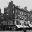
Photographs and Off-line Digital Images |
D 80908 PO |
Ministry of Works/Crown |
General view of corner site with St Giles Street before demolition for Sheriff Court House |
1930 |
Item Level |
|
|
Photographs and Off-line Digital Images |
ED 16522 |
Ministry of Works/Crown |
General view of corner site-Bank Street/High Street before demolition for building of Sheriff Court House |
c. 1930 |
Item Level |
|
|
Photographs and Off-line Digital Images |
B 78014 |
Naismith Edinburgh album |
Photographic copy of 2 engravings showing perspective view of North Bridge, and plan of Bank Street.
Insc (top) "View of the new buildings on the North Bridge, from the center nearly opposite the Post Office Richd. Crichton, Architect. Engraved by W H Lizars, Edinburgh".
(bottom) "A Sketch of Bank Street D.Lizars Sc."
Copied from Naismith Edinburgh Album F.14 |
c. 1800 |
Item Level |
|
|
Photographs and Off-line Digital Images |
B 78017 |
Naismith Edinburgh album |
Edinburgh, general.
Photographic copy of engraved sections of Bank Street
Insc: 'Sections of the Area at the Foot of Bank Street taken 10th Jany.1801 Robt.Reid, Rich. Crichton Edinr. 10th January 1801'.
Engraving.
|
10/10/1801 |
Item Level |
|
 |
On-line Digital Images |
SC 421905 |
Ministry of Works/Crown |
Scanned image of photograph showing general view of corner site-Bank Street/High Street before demolition for building of Sheriff Court House |
c. 1930 |
Item Level |
|
|
Photographs and Off-line Digital Images |
G 82005 CS |
Records of the Ordnance Survey, Southampton, Hampshire, England |
copy slide of Ordnance Survey 1st edition map of Edinburgh and its Environs, surveyed in 1852, published in 1853 at a scale of 1:1056 or five feet to one statute mile.
Sheet 35, of the area around Edinburgh Castle, Lawnmarket, Heriots Hospital and part of princes Street Gardens (west). |
31/1/1853 |
Item Level |
|
|
Photographs and Off-line Digital Images |
G 89263 CS |
Papers of William McKelvie, photographer, Edinburgh, Scotland |
View of the blue plaque dedicated to the first T.B. clinic located in Bank Street looking W |
c. 1970 |
Item Level |
|
|
Photographs and Off-line Digital Images |
G 89264 CS |
Papers of William McKelvie, photographer, Edinburgh, Scotland |
View of the blue plaque dedicated to Sir Robert Philip founder of the T.B. clinic located in Bank Street. |
c. 1970 |
Item Level |
|
 |
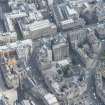
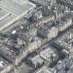
On-line Digital Images |
DP 036864 |
RCAHMS Aerial Photography Digital |
Oblique aerial view centred on new construction work at the junction of High Street and George IV Bridge, taken from the NE. |
29/11/2007 |
Item Level |
|
 |
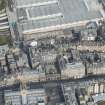
On-line Digital Images |
DP 036865 |
RCAHMS Aerial Photography Digital |
Oblique aerial view centred on new construction work at the junction of High Street and George IV Bridge, taken from the N. |
29/11/2007 |
Item Level |
|
 |
On-line Digital Images |
DP 221147 |
RCAHMS Aerial Photography Digital |
Oblique aerial view of Lady Stair's Close, Bank Street and Lawnmarket, looking NNW. |
11/9/2015 |
Item Level |
|
 |
On-line Digital Images |
DP 221149 |
RCAHMS Aerial Photography Digital |
Oblique aerial view of Lady Stair's Close, Bank Street and Lawnmarket, looking WNW. |
11/9/2015 |
Item Level |
|
 |
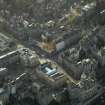
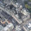
On-line Digital Images |
DP 221151 |
RCAHMS Aerial Photography Digital |
Oblique aerial view of Mound Place, Lawnmarket, Bank Street, North Bank Street, New College and Assembly Hall, looking SW. |
11/9/2015 |
Item Level |
|
 |
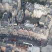
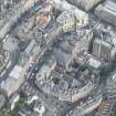
On-line Digital Images |
DP 221155 |
RCAHMS Aerial Photography Digital |
Oblique aerial view of Bank Street, Victoria Street and West Bow, looking E. |
11/9/2015 |
Item Level |
|
 |
On-line Digital Images |
DP 221156 |
RCAHMS Aerial Photography Digital |
Oblique aerial view of Bank Street, Victoria Street and West Bow, looking NW. |
11/9/2015 |
Item Level |
|
 |
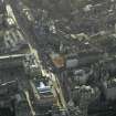
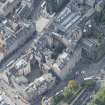
On-line Digital Images |
DP 221168 |
RCAHMS Aerial Photography Digital |
Oblique aerial view of the High Street and Bank Street, looking NE. |
11/9/2015 |
Item Level |
|
 |
On-line Digital Images |
DP 221169 |
RCAHMS Aerial Photography Digital |
Oblique aerial view of the High Street and Bank Street, looking NNW. |
11/9/2015 |
Item Level |
|


