
Skye, Dun Suladale


Broch (Iron Age)
Site Name Skye, Dun Suladale
Classification Broch (Iron Age)
Alternative Name(s) Dun Suledale
Canmore ID 11143
Site Number NG35SE 2
NGR NG 3744 5255
Datum OSGB36 - NGR
Permalink http://canmore.org.uk/site/11143


- Council Highland
- Parish Snizort
- Former Region Highland
- Former District Skye And Lochalsh
- Former County Inverness-shire
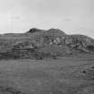
Dun Suladale, 1st millennium bc Vast and astonishingly powerful ruin of a broch standing athwart a craggy bluff above Lynedale. The circular walls (with stairways in their thickness) are built of great hewn blocks laid in courses. The entrance, with a curved approach passage, is guarded by an intact ink-bottle chamber.
Taken from "Western Seaboard: An Illustrated Architectural Guide", by Mary Miers, 2008. Published by the Rutland Press http://www.rias.org.uk

NG35SE 2 3744 5255.
(NG 3744 5255) Dun Suledale (NR)
OS 6" map, Inverness-shire, 2nd ed., (1904)
Dun Suledale, the best preserved broch in Skye, is built on an elevated site, near the centre of a plateau, bordered by rocks rising 20' - 25' in height, except towards the N, where the ground falls away in a fairly steep slope. The wall of the broch reaches a general height of 9', much of it being obscured by fallen stones. Circular on plan, it measures 42'4" in diameter at the present wall head, within a wall which varies from 10' - 12 1/2' in thickness. The entrance is from the W. On the right side of the entrance passage, a well-buiilt low doorway leads into a well-built oval beehive cell in the interior of the wall. Though the roof of the cell is broken, it still measures 9' in height. In the E arc of the wall there is another oval cell partially cleared but with the entrance covered. On the SSW, the eastern curved end of an oval cell or gallery is visible. Within the E portion of the wall what seems to be the stair is partially cleared. The entrance is at the N end. On the top of the wall as it stands at present, immediately N of the entrance passage and at a higher level than the lintels, is the curved N end of an oval cell or long gallery.
Amongst the rubbish within the broch, a short length of the straight face of a wall is seen in the N section and part of a curved wall in the SW, are probably remains of secondary buildings.
An outer defensive stone wall has crowned the edge of the plateau, its entrance being on the NW.
RCAHMS 1928, visited 1921.
As described above; well preserved.
Visited by OS (A S P) 1 June 1961.
(NG 2744 5255) Dun Suladale (NAT) Broch (NR)
OS 6"map, (1969)
A bronze spiral ring from here is in the British Museum. (Accession No: 1948, 5-4.1)
D V Clarke 1971.
Field Visit (7 June 1921)
Dun Suledale, Clachamish.
Some 150 yards east of the western boundary of the parish and about ½ mile south-west of the township of Clachamish, at an elevation of over 300 feet above sea-level, is Dun Suledale, sometimes known as Dun Suledir ,which though a ruin is the best preserved broch in Skye (Fig. 280). Not only does it contain some interesting structural features, but its situation is particularly fine. Built on an elevated site in the hilly moorland rising from the southern end of Loch Snizort on the north, it commands a fine view of that loch and the Outer Hebrides in the distance, and in other directions a wide stretch of rough heathery country encircled by hills. It stands near the centre of the plateau, which runs north-west and south-east, and is bordered by rocks rising 20 to 25 feet in height, except towards the north where the ground falls away in a fairly steep slope. The wall of the broch has a batter on the outside and reaches a general height of about 9 feet, much of it being obscured by fallen stones. The interior contains a great mass of tumbled material hiding and no doubt preserving most of the inner face of the building. The broch is practically a perfect circle, measuring internally at the present wall head 42 feet 4 inches in diameter, and the thickness of the wall varies from 10 to 12 ½ feet. The entrance is from the west, and, as it as well as other portions have been cleared of debris, its structural details are ascertainable. It is 2 feet 7 inches wide at the outside; some 3 feet 6 inches inwards is a door check on either side 5 to 6 inches deep, and thereafter the passage widens till it reaches a maximum width of 4 feet before it contracts to 3 feet 7 inches on the inside. Five lintel stones, three of them cracked, remain in posit ion, and the height of the doorway is 5 feet 8 inches. On the right side of the entrance passage, 6 feet 10 inches from the outside, a well-built low doorway, on the floor level, 2 feet 2 inches in height and 1 foot 10 inches wide, leads through a passage 2 feet 9 inches long, which increases to a height of 3 feet and to a width of 2 feet 9 inches, into a beautifully built, oval beehive cell in the interior of the wall, measuring 8 feet in length and 6 feet 6 inches in breadth at the floor level. Though the roof of the cell is broken it still measures 9 feet in height. In the eastern arc of the wall there is another oval cell partially cleared but with entrance covered; it measures about 16 feet 8 inches in length, 5 feet 5 inches in width, and 7 feet in height from the debris inside to the break of the roof. On the south-south-west the eastern curved end of an oval cell or a gallery shows a length of 9 feet and a width of 4 feet. Within the eastern portion of the wall what seems to be the stair is partially cleared. It is 3 feet wide near the foot and 2 feet 7 inches wide at its present top, the outer and inner walls measuring about 5 feet 8 inches and 3 feet 4 inches in thickness respectively. The entrance is at the northern end and the stair to the right rises southward into an upper gallery just traceable beyond the side, a well-built low doorway, on the floor level, 2 feet 2 inches in height and 1 foot 10 inches wide, leads through a passage 2 feet 9 inches long, which increases to a height of 3 feet and to a width of 2 feet 9 inches, into a beautifully built, oval beehive cell in the interior of the wall, measuring 8 feet in length and 6 feet 6 inches in breadth at the floor level. Though the roof of the cell is broken it still measures 9 feet in height. In the eastern arc of the wall there is another oval cell partially cleared but with entrance covered; it measures about 16 feet 8 inches in length, 5 feet 5 inches in width, and 7 feet in height from the debris inside to the break of the roof. On the top of the wall as it stands at present, immediately to the north of the entrance passage and at a level higher than the lintels of the passage, is the curved northern end of an oval cell or long gallery, measuring 4 feet 6 inches wide, which has been built in the thickness of the wall across the passage. No scarcement is visible but this feature might be revealed by excavation of the interior.
Amongst the rubbish in the interior of the broch a short length of the straight face of a wall is seen in the northern section and part of a curved wall in the south-west, probably remains of secondary buildings.
An outer defensive stone wall has crowned the edge of the plateau, at a distance from the broch of about 25 feet on the north-west, 15 feet on the south-west, 22 feet on the north-east, and 54 feet on the south-east. The entrance through this barrier has been from the north-west, nearly opposite the doorway in the main building, and though the wall is nearly gone and its thickness indefinite the width of the entrance is apparently about 4 feet.
RCAHMS 1928, visited 7 June 1921.
OS map: Skye xvi.
Publication Account (2007)
NG35 4 DUN SULEDALE ('Dun Suladale')
NG/3744 5255
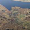
This broch, perhaps of the solid-based type, is in Snizort, Skye, and is the best preserved of these structures in the island and stands about 91.5m (300 ft) above the sea on a broad-topped rock knoll on hilly moorland (visited 22/4/63 and 14/8/85). An outer wall runs round the edge of the knoll. The site has an excellent view of the sea and overlooks an agricultural valley below.
Description
The broch wall stands about 2.7m (9 ft) in places but masses of rubble conceal much of it; the inwardly battered outer face is visible most of the way round. The well preserved entrance passage is on the west-north-west and has several lintels still in position. The passage is 79cm (2 ft 7 in) wide at the outer end, and the door-checks – one of which is formed of a large slab set on edge like those of the Caithness and Orkney brochs – are 1.07m (3 ft 6 in) down the passage and 12 - 15cm (5 - 6 in) deep. There is a bar-hole in the left wall [5].
Inwards from the door-frame the passage widens to 1.22m (4 ft) and narrows again to 1.1m (3 ft 7 in) at the inner end. The low door to a guard cell opens off the right side of the passage and the corbelled roof of the cell still rises about 2.44m (8 ft) above the debris inside it. From the angle of the slope of the roof the dome is unlikely to have risen more than another 30-60cm (1-2 ft). The cell door is only 66cm (2 ft 2 in) high.
There are clear traces of an opening or chamber on top of the entrance passage, the curved front wall of which is visible on the left of the passage and several feet back from it; thus the chamber is wider than the passage below. Access to it must have been directly from the interior. The lintels at the front end of the passage are displaced from their original positions so it is not possible to see whether defensive gaps had been left between them which could be used from the chamber above. This feature has been described as the curved north end of an oval cell or long gallery [1, 5] but this is hardly possible in view of the fact that it faces the domed corbelled roof of the guard cell on the opposite side of the passage. The existence of this chamber confirms that the building is a broch.
Another oval mural cell is visible at about 10.30 o'clock but its door is concealed: it is 3.56m (11 ft 8 in) in length, 1.66m (5 ft 5 in) wide and 2.1m (7 ft) high to the broken roof. A short distance to the right of this cell, at about 12 o'clock, is the lintelled door to a length of mural gallery which runs to the right (clockwise) and which contains the mural stair; several steps of this are exposed at about 1 o'clock. It is doubtful if there is a stair-foot guard cell in this broch as the cell, at 10.30 o'clock, seems too close to the stair door.
At about 3 o'clock is visible the curved end of a gallery or cell, full of rubble, running clockwise towards the guard cell [5, plan]; this is 1.22m (4 ft) wide and 2.75m (9 ft) of it was seen by the Commission in 1921 [2]. There are traces also of what must be an upper gallery on part of the wallhead, which is 3.05 - 3.66m (10 - 12 ft) above the ground.
There are the remains of an outer wall running round the broch; on the north-west it is about 7.6m (25 ft) distant, 4.57m (15 ft) on the south-west, 6.7m (22 ft) on the north-east and 16.5m (54 ft) on the south-east. The entrance through it is on the north-west, nearly opposite the broch doorway (a passage through the rubble to the broch entrance has been cleared here in modern times). At this point the outer wall is about 1.2m (4 ft) thick.
Find
A bronze spiral finger-ring from this site is in the British Museum (no. 1948, 5-4.1) [3].
Dimensions
Internal diameter at wallhead (and probably above scarcement) 12.90m (42 ft 4 in), wall thickness at same height 3.05 - 3.66m (10 - 12 ft). The dimensions at ground level are not available.
Sources: 1. NMRS site no. NG 35 SE 2: 2. RCAHMS 1928, 194-96, no. 618, and figs. 280 and 281: 3. Clarke 1971, 48, no. 72: 4. MacSween 1984-85, no. 16 and fig. 16: 5. Swanson (ms) 1985, 838-41 and plan.
E W MacKie 2007
Aerial Photography (2014)
NG 374 525 A programme of low altitude aerial photography was undertaken on Skye in support of FCS monument management and condition monitoring. To broaden the fieldwork objectives and demonstrate the methodology, a further site was included: the fine broch of Dun Suladale above Loch Snizort.
Low altitude vertical and oblique aerial photography uses a remote controlled microcopter equipped with a digital camera. The technique has proved remarkably adept at capturing images for illustration, site condition monitoring and for conservation management purposes, particularly in regard to upstanding masonry structures and large-scale earthworks. The technique can be used to provide both detailed images and landscape setting; and rectified vertical images can be used to support archaeological measured survey. Traditional aerial photography cannot match the detail and 360° flexibility of low altitude vertical and oblique
aerial photography by microcopter.
Archive: RCAHMS and WoSAS HER
Funder: Forestry Commission Scotland
Matt Ritchie and Ed Martin – Forestry Commission Scotland
(Source: DES)
Note (26 January 2015 - 31 May 2016)
The broch known as Dun Suladale, which is situated on a rocky hillock in open moorland, lies within a larger enclosure taking in the summit area. Polygonal on plan, the enclosure measures about 43m from NW to SE by 32m transversely (0.12ha) within a wall reduced to little more than a band of rubble with a few outer facing-stones. The entrance is on the NW, close by the WNW-facing entrance to the broch. With its walls standing some 3m high in places, the broch is much better preserved than the outer enclosure.
Information from An Atlas of Hillforts of Great Britain and Ireland – 31 May 2016. Atlas of Hillforts SC2754
Laser Scanning (20 July 2015 - 21 July 2015)
NG 374 525 A laser scan survey of the broch of Dun Suladale was undertaken, 20–21 July 2015, for conservation management purposes. The survey was undertaken using a Trimble FX laser scanner, and a detailed descriptive report and photographic record compiled.
The well preserved broch is located in the centre of a flat topped rocky outcrop 2.7km inland from the head of Loch Snizort in the NW of the Isle of Skye. The site commands open views especially to the N over Loch Snizort to Lewis and Harris beyond. Southwards the ridge of the Cuillin Hills can be seen in the distance. The broch occupies the centre of the plateau on which it sits and is surrounded by an enclosing wall, now reduced to a low grass covered stony bank, that follows the top of the rocky outcrop closely. The entrance through the enclosure wall lies to the NW, in line with the entrance to the broch itself.
The exterior broch wall stand up to 2.4m high and where not obscured by large deposits of fallen rubble the facings of the walls can be seen to be of large quarried blocks laid in rough courses with the gaps between the large blocks filled with small pinning stones, with an appreciable batter on the outer wall face.
The interior face of the broch wall is constructed in much the same manner as the outer face with large quarried blocks with small pinning stones laid in rough courses, although there is no appreciable batter to the wall. No scarcement ledge can be identified; however this feature may be obscured by the large amounts of rubble present within the interior.
The broch wall is punctuated by a number of intramural features. The entrance to the broch is on the NW of the wall circuit, this is now choked with rubble.
Four surviving lintels cap the entrance passage. No bar holes or door checks can be seen within the entrance passage.
Immediately S of and originally accessed through the right hand wall of the entrance passage is a guard cell. The guard cell comprises an oval chamber, accessed from the broch entrance passage. In the SW of the broch wall is a sub-rectangular cell. Almost directly opposite the broch entrance passage way is the entrance to a now rubble-filled passage. The interior of this cell is a curving space containing a flight of intra-mural steps, leading to the upper level of the broch. In the WNW of the broch is an oval chamber, the entrance to which is not clear and is choked with rubble. On top of the surviving wall, to the N of the entrance passage and at a higher level than the lintels is the curved N end of an oval cell or long gallery.
The interior of the broch is filled with rubble, originating from the collapse of the walls. Within this rubble two short stretches of wall face can be made out in the N and SW of the broch interior. These wall faces are probably the remains of secondary buildings constructed within the interior of the broch.
Around the base of the rocky knoll on which the broch sits lies the remains of a settlement (NG35SE 16) that consists of small sub-rectangular and sub-oval structures.
Archive: National Record of the Historic Environment (NRHE) intended
Funder: Forestry Commission Scotland
Jame Humble - AOC Archaeology Group
(Source: DES, Volume 16)

