 |
On-line Digital Images |
DP 006673 |
Records of the Royal Commission on the Ancient and Historical Monuments of Scotland (RCAHMS), Edinbu |
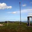
View of marker cairn, beacon and sentry box on summit of Castlelaw Hill, taken from SW |
6/6/2005 |
Item Level |
|
 |
On-line Digital Images |
DP 006771 |
Records of the Royal Commission on the Ancient and Historical Monuments of Scotland (RCAHMS), Edinbu |
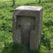
View of electricity supply point (CDTA05 230) |
26/5/2005 |
Item Level |
|
 |
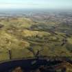
On-line Digital Images |
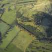
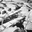
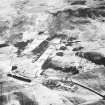
DP 006972 |
RCAHMS Aerial Photography Digital |
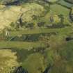
Oblique aerial photograph centered on the rifle ranges at Castlelaw, taken from the W. |
17/11/2005 |
Item Level |
|
 |
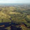
On-line Digital Images |
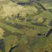
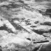
DP 012041 |
RCAHMS Aerial Photography Digital |
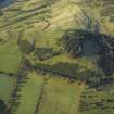
General oblique aerial view centred on the remains of the palisaded settlement, cultivation terraces, fort and rig with the rifle ranges adjacent, taken from the ESE. |
17/11/2005 |
Item Level |
|
 |
On-line Digital Images |
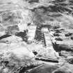
DP 012042 |
RCAHMS Aerial Photography Digital |
General oblique aerial view centred on the remains of the palisaded settlement, cultivation terraces, fort and rig with the rifle ranges, farmhouse and farmsteading adjacent, taken from the ENE. |
17/11/2005 |
Item Level |
|
 |
On-line Digital Images |
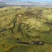
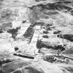
DP 012044 |
RCAHMS Aerial Photography Digital |
General oblique aerial view centred on the rifle ranges with the farmhouse and farmsteading and remains of the rig, fort, cultivation terraces and palisaded settlement adjacent, taken from the SW. |
17/11/2005 |
Item Level |
|
 |
On-line Digital Images |
DP 012045 |
RCAHMS Aerial Photography Digital |
General oblique aerial view centred on the rifle ranges, farmhouse and farmsteading and the remains of the rig, fort, cultivation terraces and palisaded settlement, taken from the SE. |
17/11/2005 |
Item Level |
|
 |
On-line Digital Images |
DP 012046 |
RCAHMS Aerial Photography Digital |
General oblique aerial view centred on the rifle ranges with the farmhouse and farmsteading and remains of the rig, fort, cultivation terraces and palisaded settlement adjacent, taken from the WNW. |
17/11/2005 |
Item Level |
|
 |
On-line Digital Images |
DP 012047 |
RCAHMS Aerial Photography Digital |
General oblique aerial view centred on the rifle ranges, farmhouse and farmsteading and the remains of the rig, fort, cultivation terraces and palisaded settlement, taken from the SW. |
17/11/2005 |
Item Level |
|
 |
On-line Digital Images |
DP 012048 |
RCAHMS Aerial Photography Digital |
General oblique aerial view centred on the rifle ranges, farmhouse and farmsteading and the remains of the rig, fort, cultivation terraces and palisaded settlement, taken from the SW. |
17/11/2005 |
Item Level |
|
 |
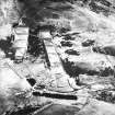
On-line Digital Images |
SC 1680708 |
RCAHMS Aerial Photography |
Oblique aerial view centred on the rifle range, taken from the NNW. |
9/2/2004 |
Item Level |
|
 |
On-line Digital Images |
SC 1680709 |
RCAHMS Aerial Photography |
Oblique aerial view centred on the rifle range with the farmhouse and farmsteading and the remains of the fort, trenches and rig adjacent, taken from the NW. |
9/2/2004 |
Item Level |
|
 |
On-line Digital Images |
SC 1680710 |
RCAHMS Aerial Photography |
Oblique aerial view centred on the rifle range with the farmhouse and farmsteading and the remains of the fort, trenches and rig adjacent, taken from the WNW. |
9/2/2004 |
Item Level |
|
 |
On-line Digital Images |
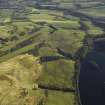
SC 1680711 |
RCAHMS Aerial Photography |
General oblique aerial view centred on the rifle range with the remains of the fort, trenches and rig adjacent, taken from the SSW. |
9/2/2004 |
Item Level |
|
 |
On-line Digital Images |
SC 1680712 |
RCAHMS Aerial Photography |
General oblique aerial view centred on the rifle range with the remains of the fort, trenches, ring-ditch house and rig adjacent, taken from the SSE. |
9/2/2004 |
Item Level |
|
 |
On-line Digital Images |
SC 1680713 |
RCAHMS Aerial Photography |
General oblique aerial view centred on the rifle range with the farmhouse and farmsteading and the remains of the fort, trenches, ring-ditch house and rig adjacent, taken from the SSE. |
9/2/2004 |
Item Level |
|
 |
On-line Digital Images |
SC 1680714 |
RCAHMS Aerial Photography |
General oblique aerial view centred on the rifle range with the farmhouse and farmsteading and the remains of the fort, trenches, ring-ditch house and rig adjacent, taken from the SE. |
9/2/2004 |
Item Level |
|
 |
On-line Digital Images |
SC 1680715 |
RCAHMS Aerial Photography |
Oblique aerial view centred on the rifle range with the remains of the fort, trenches and rig adjacent, taken from the SSE. |
9/2/2004 |
Item Level |
|


