
Skye, Bracadale Parish Church


Church (19th Century)
Site Name Skye, Bracadale Parish Church
Classification Church (19th Century)
Alternative Name(s) Balgown Parish Church
Canmore ID 11052
Site Number NG33NE 6
NGR NG 35542 38742
Datum OSGB36 - NGR
Permalink http://canmore.org.uk/site/11052


- Council Highland
- Parish Bracadale
- Former Region Highland
- Former District Skye And Lochalsh
- Former County Inverness-shire
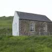
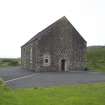
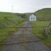
Balgown Parish Church, William Smith, 1831 A simple box with Y-traceried windows beside the Voaker burn. In the stone-walled kirkyard, remnants of an earlier pre-Reformation church and two late medieval gravestones, carvings of knight etc. still discernible. Near the waterfall above, the (former) Balgown Manse, c.1790, altered and extended by Alexander Ross, 1882.
Taken from "Western Seaboard: An Illustrated Architectural Guide", by Mary Miers, 2008. Published by the Rutland Press http://www.rias.org.uk
NG33NE 6.00 35542 38742
NG33NE 6.01 35583 38801 Churchyard and St Assind's Chapel
(NG 3553 3872) Church (NAT)
OS 6"map, Inverness-shire, 2nd ed., (1903)
A church appears to have been built at Bracadale, near the head of Loch Beag, about the middle of the 18th century to have been repaired in 1783 and to have been rebuilt in 1831; it is now the only parish church. It is said to be built on or near the site of the ancient chapel of St. Assind, to which Master John M'Kinnon was presented in 1632.
In the adjoining chuuchyard are two grave slabs with a claymore and foliaceous designs carved on each. A third stone bears in high relief the effigy of a warrior clad in a surcoat.
Visited by OS (C F W) 6 December 1960.
Statistical Account (OSA) 1792; Orig Paroch Scot 1854; RCAHMS 1928
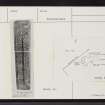
Bracadale Church is still in use but in the old graveyard to the NE, abutting on the side of a small private burial enclosure at NG 3558 3879, there are the foundations of a building said to be an old church (Information from Mr Lockhart, Bracdale). The remains consist of turf-covered foundations, orientated NE-SW, constructed of rubble masonary bonded with shell-lime mortar and divided into two compartments. The larger measures about 10.0m long by 5.0m wide internally with walling 1.5m wide and 0.7m high, the smaller 5m square internally with walling of similar dimensions.
The building has been extensively mutilated by graves which now lie both inside and on top of the walling, but its general appearance, plan and orientation suggest that it is almost certainly St. Assind's Chapel.
Visited by OS (CFW) 1 June 1961.
Measured Survey (May 2007)
NG 3553 3872 A survey of the church of St Assind's of Bracadale at the end of Loch Beag was carried out in May 2007. A 1:100 scale plan was drawn of the church. The remains of the church consist of the turf covered foundations of a roughly rectangular structure orientated E/W. The W end of the church seems to be defined by an early modern burial enclosure, although the southern turf bank/wall continues past the burial enclosure. The church appears to be a bicameral structure; the larger western end measures 10.5 x 5m internally and the
smaller eastern end measures 5 x 5m. There is a late medieval graveslab in the centre of the side of the N wall.
Funder: The Hunter Archaeological Trust and the University of Glasgow's Faculty of Arts Graduate School Research Support Fund.

