 |
On-line Digital Images |
DP 175295 |
Dr Colin and Dr Paula Martin |
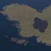
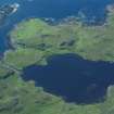
Aerial photograph of the W tip of the Rubh an Dùnain peninsula showing Loch na h-Airde and the canal linking it to the sea. The islet of Sgeir Mhòr provides a sheltered anchorage beyond the canal's mouth. (Colin Martin) |
2008 |
Item Level |
|
 |
On-line Digital Images |
DP 175296 |
Dr Colin and Dr Paula Martin |
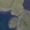
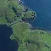
Aerial photograph of the headland fort and canal from the SE. Underwater indications of a stone-built quay can be seen on either side of the canal’s entry to the loch. Beyond the canal entrance a basin of deeper water largely clear of weed is visible. (Colin Martin) |
2008 |
Item Level |
|
 |
On-line Digital Images |
DP 175297 |
Dr Colin and Dr Paula Martin |
Aerial photograph of the headland fort and canal from the SW. Underwater indications of a stone-built quay can be seen on either side of the canal’s entry to the loch. Beyond the canal entrance a basin of deeper water largely clear of weed is visible. (Colin Martin) |
2008 |
Item Level |
|
 |
On-line Digital Images |
DP 175298 |
Dr Colin and Dr Paula Martin |
Aerial photograph of the headland fort, canal, and loch from the S. (Colin Martin) |
2008 |
Item Level |
|
 |
On-line Digital Images |
DP 175299 |
Dr Colin and Dr Paula Martin |
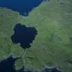
Aerial photograph of Loch na h-Airde from the NE, showing the canal, headland fort (extreme centre left) and the sheltered anchorage afforded by Sgeir Mhòr (top left). (Colin Martin) |
2008 |
Item Level |
|
 |
On-line Digital Images |
DP 175300 |
Dr Colin and Dr Paula Martin |
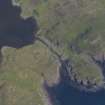
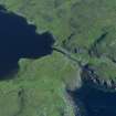
Aerial photograph of the canal and headland fort from the NW. The cleared channel towards the mouth of the canal is evident. (Colin Martin) |
2008 |
Item Level |
|
 |
On-line Digital Images |
DP 175301 |
Dr Colin and Dr Paula Martin |
Aerial photograph of the canal and headland fort from the SW. The cleared channel towards the mouth of the canal is evident. (Colin Martin) |
2008 |
Item Level |
|
 |
On-line Digital Images |
DP 175302 |
Dr Colin and Dr Paula Martin |
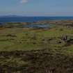
Loch na h-Airde from the settlement above Rubh’ an Dùnain, looking SW. |
2008 |
Item Level |
|
 |
On-line Digital Images |
DP 175303 |
Dr Colin and Dr Paula Martin |
Loch na h-Airde from the settlement above Rubh’ an Dùnain, looking SW. The so-called ‘Tacksman’s House’ is in the foreground. (Colin Martin) |
2008 |
Item Level |
|
 |
On-line Digital Images |
DP 175304 |
Dr Colin and Dr Paula Martin |
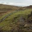
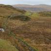
The Slochd Dubh – Black Dyke – a stone wall running from one side of the Rubh’ an Dùnain peninsula to the other, evidently defining a territorial boundary. Though the present wall is relatively modern its line shows modifications and traces of earlier structures, and the line may be of some antiquity. (Colin Martin) |
2008 |
Item Level |
|
 |
On-line Digital Images |
DP 175305 |
Dr Colin and Dr Paula Martin |
The Slochd Dubh – Black Dyke – a stone wall running from one side of the Rubh’ an Dùnain peninsula to the other, evidently defining a territorial boundary. Though the present wall is relatively modern its line shows modifications and traces of earlier structures, and the line may be of some antiquity. (Colin Martin) |
2008 |
Item Level |
|
 |
On-line Digital Images |
DP 175306 |
Dr Colin and Dr Paula Martin |
The Slochd Dubh – Black Dyke – a stone wall running from one side of the Rubh’ an Dùnain peninsula to the other, evidently defining a territorial boundary. Though the present wall is relatively modern its line shows modifications and traces of earlier structures, and the line may be of some antiquity. (Colin Martin) |
2008 |
Item Level |
|
 |
On-line Digital Images |
DP 175307 |
Dr Colin and Dr Paula Martin |
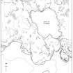
Map showing features connected with the canal and its surroundings at Rubh’ an Dùnain. (Colin Martin) |
2008 |
Item Level |
|
 |
On-line Digital Images |
DP 175308 |
Dr Colin and Dr Paula Martin |
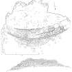
Plan and N elevation of the headland fort at Rubh’ an Dùnain. (Colin Martin) |
2008 |
Item Level |
|
 |
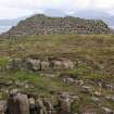
On-line Digital Images |
DP 175309 |
Dr Colin and Dr Paula Martin |
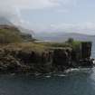
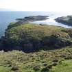
Headland fort from the W. Note the likelihood that much of its seaward interior has been lost to rock fall. (Colin Martin) |
2008 |
Item Level |
|
 |
On-line Digital Images |
DP 175310 |
Dr Colin and Dr Paula Martin |
Headland fort from the W. Note the likelihood that much of its seaward interior has been lost to rock fall. (Colin Martin) |
2008 |
Item Level |
|
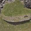 |
On-line Digital Images |
DP 175311 |
Dr Colin and Dr Paula Martin |
Vertical aerial photograph from drone of the headland fort at Rubh’ an Dùnain. (Edward Martin) |
2008 |
Item Level |
|
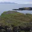 |
On-line Digital Images |
DP 175312 |
Dr Colin and Dr Paula Martin |
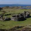
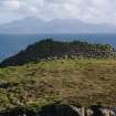
Headland fort from the NE, looking towards Rum. (Colin Martin) |
2008 |
Item Level |
|
 |
On-line Digital Images |
DP 175313 |
Dr Colin and Dr Paula Martin |
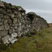
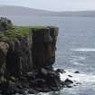
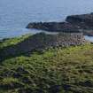
Headland fort, N face of wall, looking S towards Rum. (Colin Martin) |
2008 |
Item Level |
|
 |
On-line Digital Images |
DP 175314 |
Dr Colin and Dr Paula Martin |
Headland fort from the NE, looking towards Rum. (Colin Martin) |
2008 |
Item Level |
|
 |
On-line Digital Images |
DP 175315 |
Dr Colin and Dr Paula Martin |
Headland fort from the NE, looking towards Rum. (Colin Martin) |
2008 |
Item Level |
|
 |
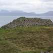
On-line Digital Images |
DP 175316 |
Dr Colin and Dr Paula Martin |
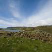
Headland fort from the NE. (Colin Martin) |
2008 |
Item Level |
|
 |
On-line Digital Images |
DP 175317 |
Dr Colin and Dr Paula Martin |
Headland fort from the NE, looking towards the islet of Sgeir Mhòr and the sheltered anchorage between. (Colin Martin) |
2008 |
Item Level |
|
 |
On-line Digital Images |
DP 175318 |
Dr Colin and Dr Paula Martin |
Headland fort, wall from interior looking N over Loch na h-Airde. (Edward Martin) |
2008 |
Item Level |
|


