
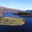
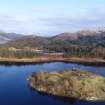
Eilean Fhianain, Burial-ground And Grave-slabs


Burial Ground(S) (Medieval), Gravestone(S) (19th Century), Gravestone(S) (20th Century), Gravestone (First World War), Brooch (Brass)
Site Name Eilean Fhianain, Burial-ground And Grave-slabs
Classification Burial Ground(S) (Medieval), Gravestone(S) (19th Century), Gravestone(S) (20th Century), Gravestone (First World War), Brooch (Brass)
Alternative Name(s) Loch Shiel
Canmore ID 108579
Site Number NM76NE 1.01
NGR NM 75224 68301
NGR Description Centred NM 75224 68301
Datum OSGB36 - NGR
Permalink http://canmore.org.uk/site/108579


- Council Highland
- Parish Arisaig And Moidart
- Former Region Highland
- Former District Lochaber
- Former County Inverness-shire
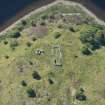
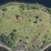
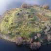
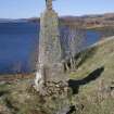
Chapel, c.1500 Believed to have been built to replace a wooden structure by Allan MacRuari, 4th Chief of Clanranald, "the dread and terror of all neighbouring clans". Abandoned 17th century, since when all dressings have been robbed. The rubble walls still enclose a stone altar slab, with a seamless bronze bell of Early Christian type (possibly 10th century), a small cross in a niche, plus various important graveslabs, including one much weathered example of the Iona School, c. late 15th century, depicting a sword and foliage scrolls. Among the many monuments scattering Eilean Fhianain in the shelter of hawthorn, larch and Scots pine are several late medieval graveslabs and a group of weathered cruciform stones, probably 18th century.
Taken from "Western Seaboard: An Illustrated Architectural Guide", by Mary Miers, 2008. Published by the Rutland Press http://www.rias.org.uk

NM76NE 1.01 centred 75224 68301
(NM 7520 6827) St. Finnan's Church (NR) (Remains of) Burying Ground (NAT)
OS 6" map, Inverness-shire, 2nd ed., (1901)
The island was the burying place of the Clan Ranalds until the end of the 16th century.
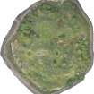
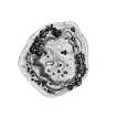
A circular brass brooch found in the burial ground was donated to the NMAS in 1896.
Proc Soc Antiq Scot 1896; M E M Donaldson 1923; W J Watson 1926; S Gordon 1935.
A pecked circle shown on OS 6"map, 1901, presumably marking the extent of the burial ground, can no longer be traced, and the whole island now appears to be is use for burial with some graves marked by small cairns rather than headstones.
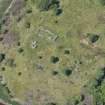
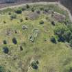
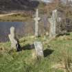
About 60.0m N of the church, on a knoll, are five rude crosses and one cross-incised slab. About 50.0m SE of the church is a heavily over-grown, sub-rectangular enclosure measuring 45.0m N-S by 40.0m transversely, formed by a tumbled stone wall spread to c. 2.0m. Perambulation revealed only a modern grave monument approximately in the centre.
Visited by OS (R L) 3 June 1970.
Non Invasive Techniques (1973 - 1974)
Iain Thornber visited Eilean Fhianain in 1973 and 1974. The collection includes original drawings of the church and Cross No. 1, historic images from his collection and a series of original photographs of the church, late medieval stones etc.
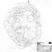
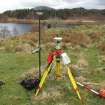
Contour Survey (1992)
A contour survey of Eilean Fhianain was undertaken after the clearing of the thick scrub that has obscured the island in recent years. In consultation with Dorothy Low of Highland Regional Council a number of gravestones, crosses, the chapel and other monuments were mapped.
Sponsor: Highland Regional Council
CFA 1992.
Reference (2001)
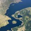
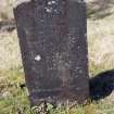
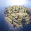
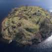
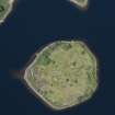
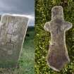
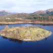
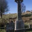
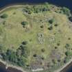
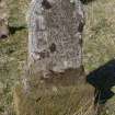
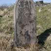
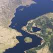
This island, which takes its name from one of the saints bearing the Irish name Finan (a), is situated about 200m from both the N and S banks of Loch Shiel. It measures about 200m from N to S by 180m and has steep sides rising to an undulating summit-area which has been extensively used for burials by the adjacent Protestant and Roman Catholic communities of Sunart and Moidart respectively (b). The ruined medieval church near the W edge of the summit contains a cast bronze bell of Early Christian type (c), as well as a graveslab and cross-head, both of late medieval date. A female effigy of the same period lies near the N end of the summit, close to a group of large simple cruciform stones which are probably of 18th-century date (d). A cross-marked gravemarker (no.1) stands in the same area, and a small cruciform stone of uncertain period (no.2) was recorded in 1974 but has since disappeared (e).
(1) [NM76NE 1.02] Tapered slab of local flagstone, 0.7m in visible height by 0.35m at the head and 55mm thick. On the E face there is incised a Latin cross, 0.17m high and 0.14m across the arms, set on a pedestal formed by a slightly curved horizontal bar 100mm long and two vertical bars 70mm high.
(2) [NM76NE 1.03] Cruciform stone with tapered shaft and side-arms, about 0.52m high by 0.22m across the arms. At the centre of one face there is an incised Latin cross, 48mm high and 20mm in span.
Footnotes:
(a) W J Watson 1926, 285-6.
(b) The monuments in the S part include an early 18th-century slab with skeleton, bearing the initials D MD. These cast doubt on its traditional identification as the grave of the Rev Alexander MacDonald ('Maighstir Alasdair', d.1724), father of the celebrated Gaelic poet of the same name (C Macdonald 1997, 123).
(c) C Bourke 1984, 464-8, citing Irish parallels of c.900. See idem 1997, Columba, 175-6, for the drop of a 12th-century crosier, found on the N shore of Loch Shiel near the island and now displayed in the Museum of Scotland (H.1993.634).
(d) For the tradition that the crosses were quarried by Donald Mor MacVarish, see A Cameron 1957. One of these is illustrated in T S Muir 1885, 77.
(e) The Commissioners are indebted to Mr I Thornber for depositing photographs, on which the drawing is based, in the NMRS (IN/1802-3).
I Fisher 2001.
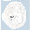
Measured Survey (22 March 2017 - 6 September 2017)
HES surveyed Eilean Fhianain between 22-24 March 2017 producing a site plan at a scale of 1:500. The site plan was created using RTK GNSS data, an image-based 3D model, vertical aerial photography and ground observation. The plan was amended on site 6 September 2017 before being redrawn in vector graphics software.
Field Visit (September 2017)
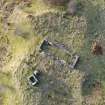
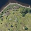
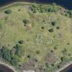
This record describes the burials arranged on the summit area of Eilean Fhianain but excludes both the NE and SW burial enclosures, for which see Canmore ID 355511 and 356229 respectively. Other individual records describe the early and late medieval gravestones (e.g. 355419), the burial aisle (355619) and the cross to Charles Macdonald (355513). The most recent burials date to 2017.
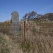
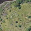
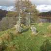
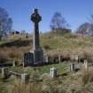
On the NW part of the upper area there is a marked concentration of about 100 grave markers set into a burial mound that measures about 30m from E to W by 15m transversely and at least 1m in height, and apparently forms the earliest visible part of the cemetery. The summit of this mound is marked by seven recumbent gravestones, two of which have large cruciform headstones which, with another two standing nearby, have been tentatively attributed to the 18th century (Fisher 2001; MacDonald 2011 edn. 104; Muir 1885, 77). One recumbent stone has an Early Medieval stone bearing an incised cross at its W end, almost certainly in re-use (ID 319525), while a late medieval graveslab with a female effigy is situated at the S edge of the mound (ID 355419). Other memorials include headstones of 19th and 20th date, and the grave of Private Mary Macdonald (W 156179) who died 26 April 1944. The E end of this burial mound has been mutilated by the insertion of a platform (NM 7521 6833) that measures about 8m in diameter into which are set at least 10 modern burials. To the E and S of this mound there are a series of simple grave markers, small cairns and headstones.
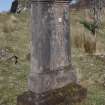
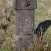
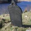
A second burial mound, perhaps occupying a natural knoll, lies about 20m to the SW and measures about 18m in diameter. It is surmounted by a small railed burial enclosure containing two 19th monuments, one a cross decorated with an angel, dedicated to John C Matheson d.1904. Among the cairns and simple grave markers there is a headstone about 1m SE of this enclosure which reads:
D. Grant l Deck Hand, RNR 4060 / H.M.S. Vernon / 23rd May 1916 Age 26
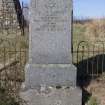
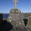
A further 3m to the SW is a table tomb which records the burial place of the notable tacksman of the area Archibald MacDonald of Rhu and Dalilea (Macdonald 2011 edn. 215-8). It is inscribed:
Sacred / To The Memory Of / Archibald Macdonald Eqr Of Dalili / Who Died At Rhue 1[0] Of May 1829 / This Stone Was Placed Here By His Widow Ann MacGregor
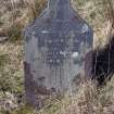
At the foot of the second burial mound, on its E side, there are a group of four headstone set on a small terrace, commemorating members of the Cameron family. The largest monument is inscribed:
Erected by / Captain Dugald Cameron / In Loving Memory Of / His Father / Donald Cameron / Free Church Elder / Kentra, Acharacle / Died 4th June 1898, Aged 70 / And / His Mother / Isabella Cameron / Died 1st Jan 1915, Aged 76 / Also the said / Captain Cameron / Died 5th June 1926, Aged 65
The remaining burials N of the church are concentrated in a well-ordered group to its NW. These are mostly simple grave markers arranged in rows but they include a fine slate headstone to Anne Chisholm d.1887.
The grave markers to the S of the church are found in two concentrations, the first to the S of the church and within about 20m, the second further to the SE. The first group is dominated by the cross and aisle of the MacDonalds of Kinlochmoidart (see ID 355619) but also includes a prominent cross to a Macpherson d.1866, and two slate headstones, for Duncan McMaster d.1879 and Christina Cameron d. c1892
The SE group stands to the E of the well-known Clach an Aoig group (see ID 355510) and to the west of the Protestant burial enclosure (see ID 356229). Arranged in ordered rows on modified terraces, this group includes small cairns and more than 20 uninscribed stones but is dominated by the headstone erected by Duncan Cameron in 1878 to his son Duncan, died 1 July 1871 aged 3.
Visited by HES Survey and Recording (GG, ATW) September 2017

