
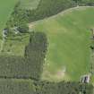
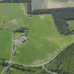
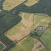
St Ford


Farmstead (18th Century)
Site Name St Ford
Classification Farmstead (18th Century)
Alternative Name(s) St Fort Farm
Canmore ID 108363
Site Number NO40SE 226
NGR NO 48144 01254
Datum OSGB36 - NGR
Permalink http://canmore.org.uk/site/108363


- Council Fife
- Parish Kilconquhar
- Former Region Fife
- Former District North East Fife
- Former County Fife
NO40SE 226 48144 01254.
This steading is open rectangular in plan. The court is now roofed over and has later detached sheds. There is a stone and slate implement shed c1900. The buildings were in agricultural use and in good order on the date of survey.
Visited and surveyed by RCAHMS (GJD), October 1995; NMRS MS 744/113 (Scottish Farm Buildings Survey).
RCAHMS and NMS, 1998a.

